Toggle navigation
LMEC Home
Exhibitions
Georeferencing
Tools for Teachers
Collections
My Favorites
Sign Up / Log In
Search
Search the map portal
Map Collection
Map Collection
Map Sets
Search
Search
Search for
Search In
All Fields
Creator
Title
Subject
Place
Search All Digital Collections
Advanced Search
527 Results
My Search
Start Over
More Like
commonwealth:q524ng442
Remove constraint More Like: commonwealth:q524ng442
Filter your Search
Place
North and Central America
459
United States
323
New York
41
Canada
26
Florida
20
Mississippi
18
Alabama
17
Chatham (county)
16
more
Place
»
Topic
Manuscript maps--Early works to 1800
138
Manuscript maps
21
Gulf Coast (U.S.)--Maps, Manuscript--Early works to 1800
12
Fortification--New York (State)--New York--Maps--Early works to 1800
11
New York (N.Y.)--Buildings, structures, etc--Maps, Manuscript--Early works to 1800
9
New York (N.Y.)--Maps, Manuscript--Early works to 1800
8
Saratoga Campaign, N.Y., 1777--Maps, Manuscript--Early works to 1800
8
Coasts--Florida--Maps--Early works to 1800
7
more
Topic
»
Date
Date range begin
–
Date range end
Current results range from
1700
to
1899
View distribution
Creator
Hills, John, (Surveyor)
18
Montrésor, John, 1736-1799
16
Dumont de Montigny
14
Bingham, William, 1752-1804
11
Adlum, John, 1759-1836
9
Washington, George, 1732-1799
9
Faden, William, 1749-1836
7
Morgan, Benjamin, (Draftsman)
7
more
Creator
»
Format
Maps/Atlases
525
Manuscripts
522
Objects/Artifacts
2
Georeferenced
Yes
6
No
521
Collection
American Revolutionary War-Era Maps
522
Library of Congress Collection
485
Newberry Library Collection
39
Maritime Charts and Atlases
32
Urban Maps
17
Boston and New England Maps
4
Norman B. Leventhal Map Center Collection
3
Available to use
Creative Commons license
485
No known restrictions
3
Search Constraints
Sort by date (asc)
relevance
title
date (asc)
date (desc)
Number of results to display per page
20 per page
10
per page
20
per page
50
per page
100
per page
View results as:
grid view
map view
Search Results
161.
A plan of part of the rivers Tombecbe, Alabama, Tensa, Perdido, & Scambia in the province of West Florida : with a sketch of...
162.
Plat of a survey of 2,314 acres of land, being the first large bottom on the east side of the Ohio River : 3 or 4 miles below...
163.
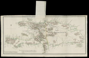
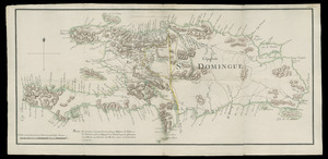
I. de St. Domingue
164.
I. de St. Domingue
165.
A plan of the division line between the provinces of New-York and Quebec : In the 45th degree of north latitude. Survey'd in...
166.
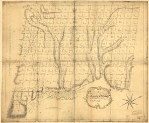
A plan of the township of Blenheim, as surveyed and divided in the year 1772
167.
A map of Potomack and James rivers in North America shewing their several communications with the navigable waters of the new...
168.
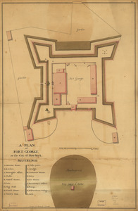
A plan of Fort George at the city of New-York
169.
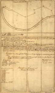
Copy of a survey return'd by Mr. Sam Lewis, surveyor of Botetourt Coun[t]y : Surveyed for George Washington 2950 acres of land...
170.
Eight survey tracts along the Kanawha River, W.Va : showing land granted to George Washington and others
171.
Esquisse du plan de la ville du Mole à St. Domingue
172.
A plan of a survey made to explore the country for a road between Connecticut River & St. Francis
173.
A plan of St. Georges Ferry on Nassau-Island made the 10th August 1774
174.
Plan of the route from St. Francis to Connecticut River
175.
Barbadoes
176.
Boston & harbour
177.
Boston, its environs and harbour : with the rebels works raised against that town in 1775
178.
Boston, S. West part : No. 25
179.
A Plan of the Battle of Bunker Hill
180.
A plan of the bay and harbor of Boston : surveyed agreeably to the orders and instructions of the Right Honorable the Lords...
‹ Prev
Next ›
1
2
…
5
6
7
8
9
10
11
12
13
…
26
27


![Copy of a survey return'd by Mr. Sam Lewis, surveyor of Botetourt Coun[t]y](https://bpldcassets.blob.core.windows.net/derivatives/images/commonwealth:q524nf40r/image_thumbnail_300.jpg)