Toggle navigation
LMEC Home
Exhibitions
Georeferencing
Tools for Teachers
Collections
My Favorites
Sign Up / Log In
Search
Search the map portal
Map Collection
Map Collection
Map Sets
Search
Search
Search for
Search In
All Fields
Creator
Title
Subject
Place
Search All Digital Collections
Advanced Search
99 Results
My Search
Start Over
More Like
commonwealth:q524n595p
Remove constraint More Like: commonwealth:q524n595p
Filter your Search
Place
World
80
North and Central America
14
United States
9
Adams (county)
7
Gettysburg National Military Park
6
Pennsylvania
3
New England
2
Arizona
1
more
Place
»
Topic
World maps
82
Pictorial maps
8
Manuscript maps
6
Population--Maps
5
Map projection
4
Telegraph lines--Maps
4
Gettysburg (Pa.)--Maps
3
Gettysburg, Battle of, Gettysburg, Pa., 1863
3
more
Topic
»
Date
Date range begin
–
Date range end
Current results range from
1482
to
2022
View distribution
Creator
Chase, Ernest Dudley, 1878-
7
Bachelder, John B. (John Badger), 1825-1894
4
ODT, Inc
4
Bien, Julius, 1826-1909
3
Brady, Mathew B., approximately 1823-1896
3
Endicott & Co. (New York, N.Y.)
3
Neumann, Louis E.
3
Carey, Mathew, 1760-1839
2
more
Creator
»
Format
Maps/Atlases
94
Manuscripts
8
Photographs
3
Books
1
Documents
1
Georeferenced
Yes
3
No
96
Collection
Norman B. Leventhal Map Center Collection
97
American Revolutionary War-Era Maps
5
Boston and New England Maps
2
Sidney R. Knafel Map Collection at Phillips Academy
2
Urban Maps
1
Available to use
No known restrictions
84
Creative Commons license
4
Search Constraints
Sort by date (desc)
relevance
title
date (asc)
date (desc)
Number of results to display per page
20 per page
10
per page
20
per page
50
per page
100
per page
View results as:
grid view
map view
Search Results
41.
Kaufmännische wandkarte der erde zur übersicht der handelsbeziehungen, dampfer- und kabel-verbindungen des Deutschen Reiches...
42.
Stanford's library map of the world on Mercator's projection
43.
Chart of the world showing area in the Pacific Ocean having Hawaii as the only base of supplies in transpacific voyages and...
44.
Caerte van de voornaemste reysen ende ontdeckingen door de Hollanders gedaen, alsook vande landen, plaetsen ende factoriën in...
45.
American Radiator Company trade card
46.
Gleason's new standard map of the world : on the projection of J. S. Christopher, Modern College, Blackheath, England ;...
47.
[Carte marine de la mer Baltique, de la mer du Nord, de l'océan Atlantique Est, de la mer Méditerranée, de la mer Noire et...
48.
Submarine cable chart of the world : showing also the seacoast stations and the principal connecting land lines ; for the use...
49.
Imperial Federation, map of the world showing the extent of the British Empire in 1886
50.
Magnetic variation chart for the year 1882
51.
Diqiu quan tu
52.
[Mid]dleton's [pione]er map of the [w]orld, [as a?] plane and immoveable
53.
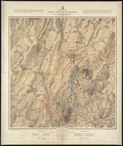
Map of the battle field of Gettysburg, July 1st, 2nd, 3rd, 1863 : Second day's battle
54.
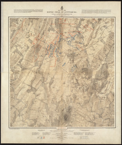
Map of the battle field of Gettysburg, July 1st, 2nd, 3rd, 1863 : First day's battle
55.
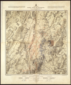
Map of the battle field of Gettysburg, July 1st, 2nd, 3rd, 1863 : Third day's battle
56.
Map showing the telegraph lines in operation, under contract, and contemplated, to complete the circuit of the globe
57.
Chikyū bankoku hōzu
58.
Map of Boston and adjacent country showing that city to be the geographical as well as intellectual and moral centre of one...
59.
Map showing the telegraph lines in operation, under contract, and contemplated, to complete the circuit of the globe
60.
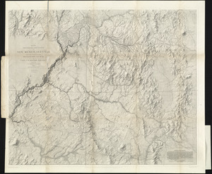
Map of explorations and surveys in New Mexico and Utah made under the direction of the Secretary of War by Capt. J. N. Macomb...
‹ Prev
Next ›
1
2
3
4
5


![[Carte marine de la mer Baltique, de la mer du Nord, de l'océan Atlantique Est, de la mer Méditerranée, de la mer Noire et de la mer Rouge]](https://bpldcassets.blob.core.windows.net/derivatives/images/commonwealth:4m90fm28z/image_thumbnail_300.jpg)


![[Mid]dleton's [pione]er map of the [w]orld, [as a?] plane and immoveable](https://bpldcassets.blob.core.windows.net/derivatives/images/commonwealth:7h149v84p/image_thumbnail_300.jpg)