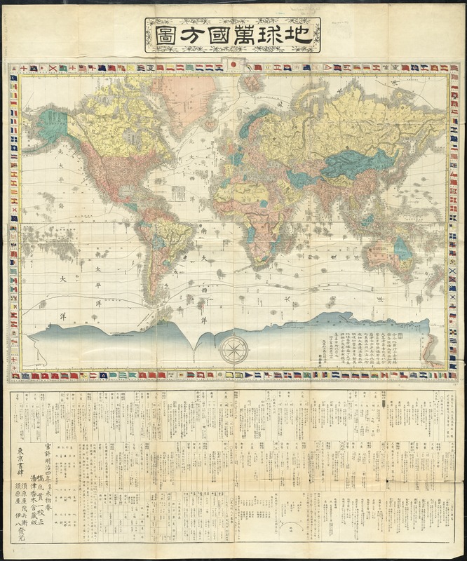
Chikyū bankoku hōzu
Item Information
- Title:
- Chikyū bankoku hōzu
- Title (alt.):
-
Japanese world map
- Creator:
- Hashizume, Kanʼichi, d. 1884
- Name on Item:
-
Hashizume Kan'ichi kōsei ; [engraved by] Matsuda Rokuzan.
- Date:
-
[1871]
- Format:
-
Maps/Atlases
- Location:
-
Boston Public Library
Norman B. Leventhal Map & Education Center - Collection (local):
-
Norman B. Leventhal Map & Education Center Collection
- Subjects:
-
World maps
- Places:
-
World
- Extent:
- 1 map : col. ; 64 x 91 cm., on sheet 120 x 100 cm., folded to 26 x 17 cm.
- Terms of Use:
-
No known copyright restrictions.
No known restrictions on use.
- Publisher:
-
Tōkyō :
Suharaya Mohē ; Suharaya Ihachi
- Scale:
-
Scale not given.
- Language:
-
Japanese
- Notes:
-
Relief shown by hachures.
Brief geographical descriptions: major cities, railroad networks, measurement, currencies, etc. below map.
Below map: "Kakkoku yūmei no chimei jōkisharo no sōkei shakudo kōryō oyobi kahei tō no ryakuki."
Preface by Shigetei Murakami Yoshishige, dated Meiji 3 [1870].
Colophon: Kankyo Meiji 4 [1871] Shinbi shoshun. Hashizume Kan'ichi kōsei, Yutsu Katsuragisha zōhan. Tōkei shoshi ; Suharaya Mohē, Suharaya Ihachi hatsuda.
"Dai Nihon honpō dōsen kaiki dai 2-sei, Tōkyō shutchōjo ni oite Gengendō Matsuda Rokuzan kore o eru."
Map bordered by national flags.
In Japanese.
- Notes (date):
-
This date is inferred.
- Identifier:
-
06_01_008281
- Call #:
-
G3200 1871 .C45
- Barcode:
-
39999065651240


