Toggle navigation
LMEC Home
Exhibitions
Georeferencing
Tools for Teachers
Collections
My Favorites
Sign Up / Log In
Search
Search the map portal
Map Collection
Map Collection
Map Sets
Search
Search
Search for
Search In
All Fields
Creator
Title
Subject
Place
Search All Digital Collections
Advanced Search
504 Results
My Search
Start Over
More Like
commonwealth:mw22xt07f
Remove constraint More Like: commonwealth:mw22xt07f
Filter your Search
Place
North and Central America
504
United States
501
Suffolk (county)
398
Boston
396
Massachusetts
273
Dorchester
48
Roxbury
47
Middlesex (county)
30
more
Place
»
Topic
Real property--Massachusetts--Boston--Maps
251
Landowners--Massachusetts--Boston--Maps
168
Boston (Mass.)--Maps
140
City planning--Massachusetts--Boston--Maps
125
Buildings--Massachusetts--Boston--Maps
122
Urban renewal--Massachusetts--Boston--Maps
78
Roxbury (Boston, Mass.)--Maps
48
Dorchester (Boston, Mass.)--Maps
46
more
Topic
»
Date
Date range begin
–
Date range end
Current results range from
1798
to
2023
View distribution
Creator
Boston Redevelopment Authority
123
Bromley, George Washington
80
Bromley, Walter Scott
80
G.W. Bromley & Co.
58
Hopkins, Griffith Morgan, Jr.
27
Geo. H. Walker & Co.
23
Wadsworth, Alexander, 1806-1898
19
Lamb, George
16
more
Creator
»
Format
Maps/Atlases
503
Manuscripts
4
Drawings/Illustrations
1
Georeferenced
Yes
14
No
490
Collection
Boston and New England Maps
349
Urban Maps
345
Norman B. Leventhal Map & Education Center Collection
245
Massachusetts Real Estate Atlases
143
Boston Redevelopment Authority Collection
140
American Revolutionary War-Era Maps
1
Available to use
No known restrictions
359
Creative Commons license
2
Search Constraints
Sort by relevance
relevance
title
date (asc)
date (desc)
Number of results to display per page
20 per page
10
per page
20
per page
50
per page
100
per page
View results as:
grid view
map view
Search Results
121.
Atlas of the county of Suffolk, Massachusetts : vol. 2nd late city of Roxbury, now wards 13-14 and 15, city of Boston
122.
Atlas of the county of Suffolk, Massachusetts : vol. 4th including East Boston, city of Chelsea, Revere and Winthrop : from...
123.
Atlas of the county of Suffolk, Massachusetts : vol. 6th including the late city of Charlestown, now wards 20,21 and 22, city...
124.
Boylston Street : Fenway to Massachusetts Avenue
125.
Campus High School urban renewal area Mass. r-129 : property map
126.
City atlas of Boston, Massachusetts : complete in one volume : from official records, private plans and actual surveys
127.
Copies of plans of various parts of Brookline and Roxbury
128.
East Boston flood risk
129.
Mattapan project : property map
130.
Plan of an estate belonging to the City of Boston to be sold by public auction on Wednesday, Sept. 14th, 1881 ... : per order...
131.
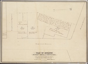
Plan of building lots on Phillips Place, Tremont & Somerset Streets
132.
Plan of building lots on Phillips Place, Tremont & Somerset Streets
133.
Plan of city lands and streets s.w. of Dover St : prepared from new surveys
134.
Plan of city lands to be sold Oct. 30th 1850
135.
Plan of City Wharf in Boston, Mass : shewing 14 lots of land on the side of the south dock of said wharf & Commercial St. : to...
136.
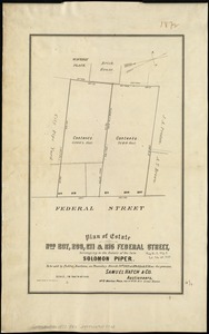
Plan of estate nos 207, 209, 211 & 215 Federal Street, belonging to the estate of the late Solomon Piper : to be sold at public...
137.
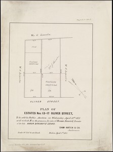
Plan of estates nos. 13-17 Oliver Street, to be sold by public auction on Wednesday April 12th 1871 at 12 o'clock m. on the...
138.
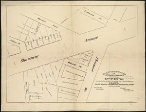
Plan of estates on Beacon St., Somerset St. & Pemberton Square : to be sold at auction by Whitwells & Seaver, on Thursday June...
139.
Plan of estates on Suffolk St. District : belonging to the City of Boston : to be sold at public auction, Dec. 23rd 1871
140.
Plan of house lots in Boston belonging to Otis H. Weed
‹ Prev
Next ›
1
2
3
4
5
6
7
8
9
10
11
…
25
26