Toggle navigation
LMEC Home
Exhibitions
Georeferencing
Tools for Teachers
Collections
My Favorites
Sign Up / Log In
Search
Search the map portal
Map Collection
Map Collection
Map Sets
Search
Search
Search for
Search In
All Fields
Creator
Title
Subject
Place
Search All Digital Collections
Advanced Search
8922 Results
My Search
Start Over
More Like
commonwealth:m900r9945
Remove constraint More Like: commonwealth:m900r9945
Filter your Search
Place
North and Central America
6,153
United States
5,069
Massachusetts
2,145
Europe
1,396
Suffolk (county)
1,268
Boston
1,241
Canada
449
Asia
438
more
Place
»
Topic
Boston (Mass.)--Maps
753
United States--Maps
282
Real property--Massachusetts--Boston--Maps
254
City planning--Massachusetts--Boston--Maps
188
Landowners--Massachusetts--Boston--Maps
170
Massachusetts--Maps
166
New England--Maps
104
North America--Maps--Early works to 1800
103
more
Topic
»
Date
Date range begin
–
Date range end
Current results range from
1482
to
2023
View distribution
Creator
United States. Hydrographic Office
595
Boston Redevelopment Authority
193
O.H. Bailey & Co
148
Des Barres, Joseph F. W. (Joseph Frederick Wallet), 1722-1824
124
United States. Post Office Dept
120
Ptolemy, 2nd cent
100
Walling, Henry Francis, 1825-1888
94
Geological Survey (U.S.)
87
more
Creator
»
Format
Maps/Atlases
8,862
Manuscripts
215
Prints
56
Books
36
Objects/Artifacts
10
Drawings/Illustrations
8
Posters
5
Georeferenced
Yes
885
No
8,037
Collection
Norman B. Leventhal Map & Education Center Collection
8,725
Boston and New England Maps
2,392
Urban Maps
2,176
Maritime Charts and Atlases
1,083
American Revolutionary War-Era Maps
638
Boston Redevelopment Authority Collection
224
Massachusetts Real Estate Atlases
38
Mapping Boston Collection
20
more
Collection
»
Available to use
No known restrictions
8,699
Creative Commons license
70
Search Constraints
Sort by relevance
relevance
title
date (asc)
date (desc)
Number of results to display per page
20 per page
10
per page
20
per page
50
per page
100
per page
View results as:
grid view
map view
Search Results
6781.
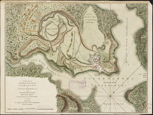
A plan of the town and Fort of Carillon at Ticonderoga : with the attack made by the British army commanded by Genl....
6782.
Plan of the town and fort of Grenada
6783.
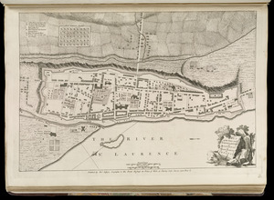
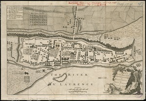
Plan of the town and fortifications of Montreal or Ville Marie in Canada
6784.
Plan of the town and fortifications of Montreal or Ville Marie in Canada
6785.
A plan of the town and harbour of Boston, and the country adjacent with the road from Boston to Concord shewing the place of...
6786.
Plan of the town and harbour of San Juan de Puerto Rico ; Plan of the Aguada Nueva de Puerto Rico
6787.
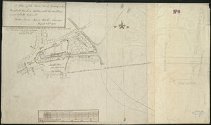
A plan of the town dock, formerly called Bendalls Dock, in Boston, with the buildings round & flats before it
6788.
Plan of the town of Basse Terre the capital of Guadaloupe from an authentic survey
6789.
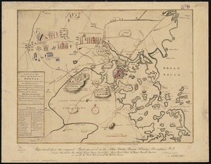
Plan of the town of Boston and circumjacent country shewing the present situation of the Kings troops & the Rebels...
6790.
Plan of the town of Boston, with the attack on Bunkers-Hill, in the peninsula of Charlestown, the 17th of June, 1775
6791.
Plan of the town of Boston with the attack on Bunkers-Hill in the peninsula of Charlestown the 17th of June 1775
6792.
Plan of the town of Cayenne and Fort St. Michael
6793.
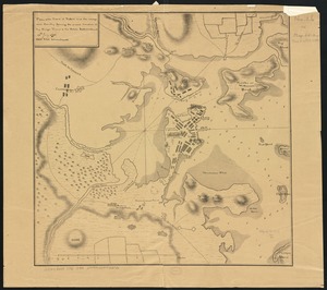
Plan of the town of Dorchester
6794.
Plan of the town of Lowell and Belvidere Village
6795.
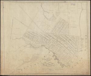
Plan of the town of Meriden, New Haven County, Connecticut
6796.
Plan of the town of Millbury : Worcester Co. Mass. : from recent and actual surveys
6797.
A plan of the town of New Bern
6798.
A plan of the town of New Haven : with all the buildings in 1748 taken by the Hon. Gen. Wadsworth of Durham to which are added...
6799.
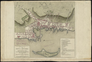
A plan of the town of Newport in Rhode Island
6800.
A plan of the town of Newport in the province of Rhode Island
‹ Prev
Next ›
1
2
…
336
337
338
339
340
341
342
343
344
…
446
447