Toggle navigation
LMEC Home
Exhibitions
Georeferencing
Tools for Teachers
Collections
My Favorites
Sign Up / Log In
Search
Search the map portal
Map Collection
Map Collection
Map Sets
Search
Search
Search for
Search In
All Fields
Creator
Title
Subject
Place
Search All Digital Collections
Advanced Search
391 Results
My Search
Start Over
More Like
commonwealth:hx11z600p
Remove constraint More Like: commonwealth:hx11z600p
Filter your Search
Place
North and Central America
351
United States
230
Canada
105
Essex (county)
24
Louisbourg
22
Saint Lawrence River
19
Charleston (county)
18
Charleston
17
more
Place
»
Topic
United States--History--French and Indian War, 1754-1763--Maps, Manuscript--Early works to 1800
58
Louisbourg (N.S.)--Maps, Manuscript--Early works to 1800
18
Fort Edward (N.Y.)--Maps, Manuscript--Early works to 1800
16
Fort Ticonderoga (N.Y.)--Maps, Manuscript--Early works to 1800
15
Saint Lawrence River--Maps, Manuscript--Early works to 1800
15
Louisbourg (N.S.)--History--Siege, 1745--Maps, Manuscript--Early works to 1800
14
Charleston (S.C.)--Maps--Early works to 1800
13
Fortification--New York (State)--Fort Edward--Maps, Manuscript--Early works to 1800
13
more
Topic
»
Date
Date range begin
–
Date range end
Current results range from
1664
to
1816
View distribution
Creator
Royal United Services Institute for Defence and Security Studies
160
George, III, King of Great Britain, 1738-1820
151
George, IV, King of Great Britain, 1762-1830
150
Amherst, Jeffery Amherst, Baron, 1717-1797
128
Skinner, Monier
28
Skinner, William, 1700-1780
28
Brasier, William
16
Bastide, John Henry, approximately 1700-1770
15
more
Creator
»
Format
Maps/Atlases
374
Manuscripts
151
Drawings/Illustrations
15
Georeferenced
Yes
7
No
384
Collection
British Library Collection
376
American Revolutionary War-Era Maps
364
Boston and New England Maps
22
Norman B. Leventhal Map & Education Center Collection
10
Maritime Charts and Atlases
7
Urban Maps
4
Harvard Map Collection
2
Library of Congress Collection
1
more
Collection
»
Available to use
Creative Commons license
380
No known restrictions
10
Search Constraints
Sort by relevance
relevance
title
date (asc)
date (desc)
Number of results to display per page
20 per page
10
per page
20
per page
50
per page
100
per page
View results as:
grid view
map view
Search Results
381.
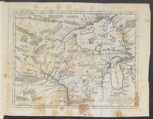
To the Rt. Honble. the Earl of Hillsborough & the rest of the Lords, Commissioners for Trade & Plantations. This Plan is most...
382.
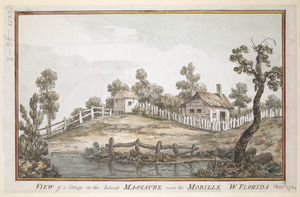
VIEW of a Cottage on the Island MASSACRE near the MOBILLE W. FLORIDA. Oct.r 1764
383.
VIEW of BOSTON the Capital of NEW ENGLAND from Col. HATCH's House on the Road to DORCHESTER = VIEW FROM DORCHESTER NECK = VIEW...
384.
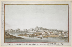
VIEW of HARLAEM from MORISANIA in the PROVINCE of NEW YORK Septem.r 1765
385.
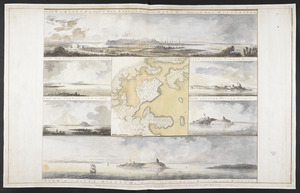
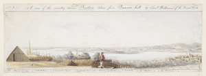
A View of the country round Boston taken from Beacon hill : shewing the Lines, Ridouts & Different Encampments of the Rebels...
386.
[View of the country round Boston taken from Beacon hill]
387.
[View of the country round Boston taken from Beacon hill]
388.
[View of the country round Boston taken from Beacon hill]
389.
[View of the country round Boston taken from Beacon hill]
390.
[View of the country round Boston taken from Beacon hill]
391.
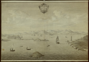
A VIEW of the TOWN & HARBOUR of LOUISBOURG
‹ Prev
Next ›
1
2
…
16
17
18
19
20
![[View of the country round Boston taken from Beacon hill]](https://bpldcassets.blob.core.windows.net/derivatives/images/commonwealth:6108vv93v/image_thumbnail_300.jpg)
![[View of the country round Boston taken from Beacon hill]](https://bpldcassets.blob.core.windows.net/derivatives/images/commonwealth:6108vv97z/image_thumbnail_300.jpg)
![[View of the country round Boston taken from Beacon hill]](https://bpldcassets.blob.core.windows.net/derivatives/images/commonwealth:6108vv95d/image_thumbnail_300.jpg)
![[View of the country round Boston taken from Beacon hill]](https://bpldcassets.blob.core.windows.net/derivatives/images/commonwealth:6108vv99h/image_thumbnail_300.jpg)
![[View of the country round Boston taken from Beacon hill]](https://bpldcassets.blob.core.windows.net/derivatives/images/commonwealth:6108vw01b/image_thumbnail_300.jpg)