Toggle navigation
LMEC Home
Exhibitions
Georeferencing
Tools for Teachers
Collections
My Favorites
Sign Up / Log In
Search
Search the map portal
Map Collection
Map Collection
Map Sets
Search
Search
Search for
Search In
All Fields
Creator
Title
Subject
Place
Search All Digital Collections
Advanced Search
9123 Results
My Search
Start Over
More Like
commonwealth:ht250q02z
Remove constraint More Like: commonwealth:ht250q02z
Filter your Search
Place
North and Central America
6,354
United States
5,270
Massachusetts
2,200
Suffolk (county)
1,469
Boston
1,442
Europe
1,396
Canada
449
Asia
438
more
Place
»
Topic
Boston (Mass.)--Maps
752
City planning--Massachusetts--Boston--Maps
418
United States--Maps
282
Urban renewal--Massachusetts--Boston--Maps
252
Real property--Massachusetts--Boston--Maps
225
Massachusetts--Maps
166
Landowners--Massachusetts--Boston--Maps
144
New England--Maps
104
more
Topic
»
Date
Date range begin
–
Date range end
Current results range from
1482
to
2023
View distribution
Creator
United States. Hydrographic Office
595
Boston Redevelopment Authority
398
O.H. Bailey & Co
148
Des Barres, Joseph F. W. (Joseph Frederick Wallet), 1722-1824
124
United States. Post Office Dept
120
Ptolemy, 2nd cent
100
Walling, Henry Francis, 1825-1888
94
Geological Survey (U.S.)
87
more
Creator
»
Format
Maps/Atlases
9,063
Manuscripts
215
Prints
56
Books
36
Objects/Artifacts
10
Drawings/Illustrations
8
Posters
5
Georeferenced
Yes
885
No
8,238
Collection
Norman B. Leventhal Map & Education Center Collection
8,723
Boston and New England Maps
2,619
Urban Maps
2,401
Maritime Charts and Atlases
1,083
American Revolutionary War-Era Maps
638
Boston Redevelopment Authority Collection
453
Mapping Boston Collection
20
Massachusetts Real Estate Atlases
12
more
Collection
»
Available to use
No known restrictions
8,926
Creative Commons license
70
Search Constraints
Sort by relevance
relevance
title
date (asc)
date (desc)
Number of results to display per page
20 per page
10
per page
20
per page
50
per page
100
per page
View results as:
grid view
map view
Search Results
601.
[Plan of channels and flats as they were before the 200 feet outside of the Mill Dam was filled up]
602.
Plan of Charles River and Warren bridges, with the vicinity
603.
Plan of Church St. district, showing estates and buildings : as proposed to be taken by the city of Boston under the Act of the...
604.
Plan of city lands to be sold Oct. 30th 1850
605.
Plan of City Wharf in Boston, Mass : shewing 14 lots of land on the side of the south dock of said wharf & Commercial St. : to...
606.
Plan of estate, nos 1043 to 1059 Washington Street, Boston, belonging to the heirs of the late William Brigham : to be sold by...
607.
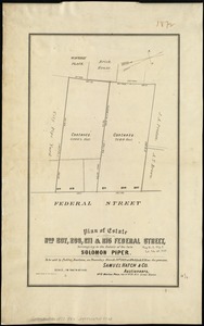
Plan of estate nos 207, 209, 211 & 215 Federal Street, belonging to the estate of the late Solomon Piper : to be sold at public...
608.
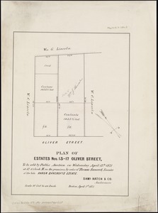
Plan of estates nos. 13-17 Oliver Street, to be sold by public auction on Wednesday April 12th 1871 at 12 o'clock m. on the...
609.
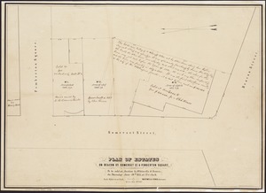
Plan of estates on Beacon St., Somerset St. & Pemberton Square : to be sold at auction by Whitwells & Seaver, on Thursday June...
610.
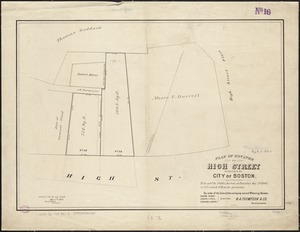
Plan of estates on High Street belonging to the City of Boston : to be sold by public auction on Thursday May 21st 1868, at 12...
611.
Plan of estates on Suffolk St. District : belonging to the City of Boston : to be sold at public auction, Dec. 23rd 1871
612.
Plan of estates on Suffolk St. district : belonging to the City of Boston : to be sold at public auction on Saturday Dec. 16th...
613.
Plan of estates on Suffolk Street district, belonging to the City of Boston, to be sold at public auction, on Saturday, May 11,...
614.
Plan of extension of Devonshire Street, by two routes through Otis and Winthrop Places
615.
Plan of extension of Devonshire Street connecting Otis & Winthrop Places
616.
Plan of Fort Hill showing improvements as proposed by the Committee on laying out and widening streets
617.
Plan of Fort Hill showing street improvements as adopted by the city council : 1869
618.
Plan of Gray's Wharf, to be sold at public auction, on the premises, on Thursday April 28th 1870 at 12 o'clock noon
619.
Plan of land & wharves belonging to Mill Pond Wharf Co. near Bartons Point
620.
Plan of land on Bedford and Avon Streets belonging to the proprietors of the Second Church in Boston : to be sold by public...
‹ Prev
Next ›
1
2
…
27
28
29
30
31
32
33
34
35
…
456
457
![[Plan of channels and flats as they were before the 200 feet outside of the Mill Dam was filled up]](https://bpldcassets.blob.core.windows.net/derivatives/images/commonwealth:b8516207x/image_thumbnail_300.jpg)