Toggle navigation
LMEC Home
Exhibitions
Georeferencing
Tools for Teachers
Collections
My Favorites
Sign Up / Log In
Search
Search the map portal
Map Collection
Map Collection
Map Sets
Search
Search
Search for
Search In
All Fields
Creator
Title
Subject
Place
Search All Digital Collections
Advanced Search
419 Results
My Search
Start Over
More Like
commonwealth:hq37vv62q
Remove constraint More Like: commonwealth:hq37vv62q
Filter your Search
Place
North and Central America
325
North America
230
United States
153
New England
100
Middle Atlantic
38
Canada
31
Massachusetts
27
New York
18
more
Place
»
Topic
North America--Maps--Early works to 1800
240
New England--Maps--Early works to 1800
97
Middle Atlantic States--Maps--Early works to 1800
38
Great Britain--Colonies--America--Maps--Early works to 1800
18
Canada--Maps--Early works to 1800
16
Northeastern States--Maps--Early works to 1800
14
United States--Maps--Early works to 1800
14
World maps--Early works to 1800
13
more
Topic
»
Date
Date range begin
–
Date range end
Current results range from
1482
to
1999
View distribution
Creator
Jefferys, Thomas, -1771
22
Sayer, Robert, 1725-1794
20
Mitchell, John, 1711-1768
19
Gibson, J. (John), active 1750-1792
14
Anville, Jean Baptiste Bourguignon d', 1697-1782
11
Bowen, Emanuel, 1693 or 1694-1767
11
Moll, Herman, d. 1732
11
Bowles, Carington, 1724-1793
10
more
Creator
»
Format
Maps/Atlases
419
Manuscripts
4
Books
1
Georeferenced
Yes
22
No
397
Collection
American Revolutionary War-Era Maps
255
Norman B. Leventhal Map & Education Center Collection
181
Sidney R. Knafel Map Collection at Phillips Academy
87
MacLean Collection Map Library
67
New York Public Library Collection
38
Mapping Boston Collection
33
Boston and New England Maps
31
Richard H. Brown Revolutionary War Map Collection at Mount Vernon
26
more
Collection
»
Available to use
No known restrictions
153
Creative Commons license
107
Search Constraints
Sort by relevance
relevance
title
date (asc)
date (desc)
Number of results to display per page
20 per page
10
per page
20
per page
50
per page
100
per page
View results as:
grid view
map view
Search Results
321.
North America, divided into its principall parts where are distinguished the severall states which belong to the English,...
322.
North America, drawn from the best authorities
323.
North America drawn from the latest and best authorities
324.
North America from the French of Mr. D'Anville, improved with the back settlements of Virginia and course of Ohio, illustrated...
325.
North America from the French of Mr. D'Anville, improved with the back settlements of Virginia and course of Ohio, illustrated...
326.
North America with the new discoveries
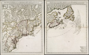
327.
The north part of America : conteyning Newfoundland, new England, Virginia, Florida, new Spaine, and Noua Francia wth ye rich...
328.
The north-west-coast of North America and adjacent territories
329.
Norumbega et Virginia
330.
Noua et accurata totius Americae tabula
331.
Le Nouveau Mexique et la Floride : tirées de diverses cartes, et relations
332.
Nova mappa geographica America Septentrionalis in suas praecipuas partes divisa = Amerique Septentrionale suivent [sic] la...
333.
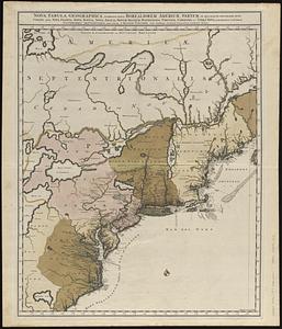
Nova tabula geographica complectens borealiorem Americae partem : in qua exacte delineatae sunt Canada sive Nova Francia, Nova...
334.
Nova tabula geographica complectens borealiorem Americae partem : in qua exacte delineatae sunt Canada sive Nova Francia, Nova...
335.
Nova tabula geographica complectens borealiorem Americæ partem : in qua exacte delineatæ sunt Canada sive Nova Francia, Nova...
336.
Nova tabula geographica complectens borealiorem Americæ partem : in qua exacte delineatæ sunt Canada sive Nova Francia, Nova...
337.
Novissima et accuratissima totius Americae descriptio
338.
La Nuoua Francia
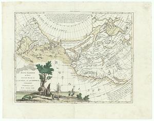
339.
Nuove scoperte de' russi al nord del mare del sud si nell' Asia, che nell America
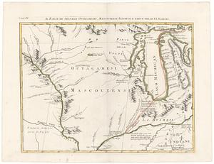
340.
Il paese de' selvagi Outagamiani, Mascoutensi Illinesi e parte delle VI. Nazioni
‹ Prev
Next ›
1
2
…
13
14
15
16
17
18
19
20
21