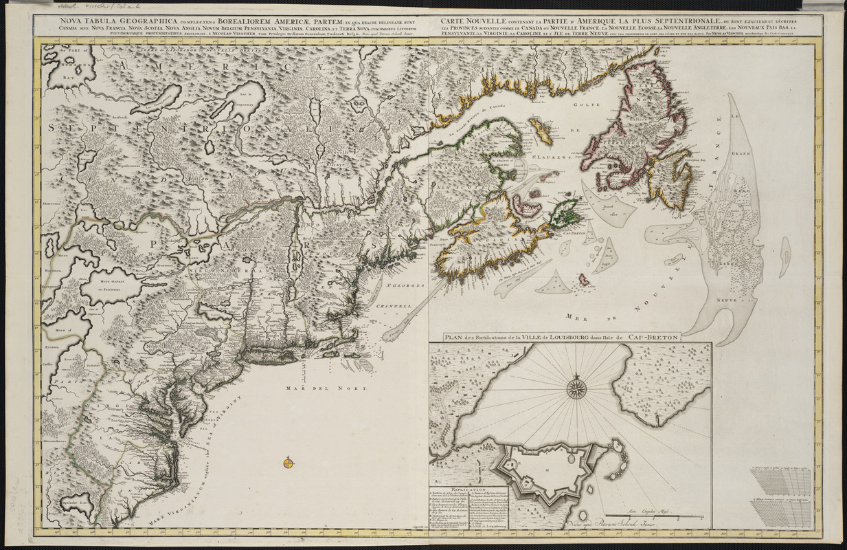
Nova tabula geographica complectens borealiorem Americæ partem : in qua exacte delineatæ sunt Canada sive Nova Francia, Nova Scotia, Nova Anglia, Novum Belgium, Pensylvania, Virginia, Carolina, et Terra Nova, cum omnibus littorum, pulvinorumque profunditabus
Item Information
- Title:
- Nova tabula geographica complectens borealiorem Americæ partem : in qua exacte delineatæ sunt Canada sive Nova Francia, Nova Scotia, Nova Anglia, Novum Belgium, Pensylvania, Virginia, Carolina, et Terra Nova, cum omnibus littorum, pulvinorumque profunditabus
- Title (alt.):
-
Carte nouvelle contenant la partie d'Amerique la plus septentrionale : ou sont exactement dêcrites les provinces suivantes comme le Canada ou Nouvelle France, la Nouvelle Ecosse, la Nouvelle Angleterre, les Nouveaux Païs Bas, la Pensylvanie, la Virginie, la Caroline et l'Jle de Terre Neuve avec les profondeuis le long des côtes et sur les bancs
- Description:
-
This pair of late-17th-century Dutch maps depicts the French and British colonies in northeastern North America extending from the Carolinas to Newfoundland. The map's central focus includes New England along with the former Dutch colony of New Netherlands and the French settlements along the St. Lawrence River, labeled as New France or Canada. Names of indigenous tribes occupy the unknown interior, while the settled coast has European place names. First published about 1689, this is the last state of the map (published about 1720), which is identified by an inset showing the French fortress of Louisburg on Cape Breton Island.
- Creator:
- Visscher, Nicolaes, 1649-1702
- Contributor:
- Anse, Luggert van, fl. 1690-1716
- Contributor:
- Schenk, Peter, II, 1693-1775
- Name on Item:
-
à Nicolao Visscher ; Luggardus van Anse, schulp. = Carte nouvelle contenant la partie d'Amerique la plus septentrionale : ou sont exactement dêcrites les provinces suivantes comme le Canada ou Nouvelle France, la Nouvelle Ecosse, la Nouvelle Angleterre, les Nouveaux Païs Bas, la Pensylvanie, la Virginie, la Caroline et l'Jle de Terre Neuve avec les profondeuis le long des côtes et sur les bancs / par Nicolas Visscher
- Date:
-
[1720]
- Format:
-
Maps/Atlases
- Location:
- Private Collection
- Collection (local):
-
Mapping Boston Collection
- Subjects:
-
North America--Maps--Early works to 1800
- Places:
-
North America (area)
- Extent:
- 1 map on 2 sheets : col. ; 55 x 91 cm., sheets 63 x 54 cm.
- Terms of Use:
-
No known copyright restrictions.
This work is licensed for use under a Creative Commons Attribution Non-Commercial Share Alike License (CC BY-NC-SA).

- Publisher:
-
Amsterdam :
Nicolao Visscher
- Scale:
-
Scale [ca. 1:4,500,000]
- Language:
-
Latin
French
- Notes:
-
Relief shown pictorially.
- Notes (date):
-
This date is inferred.
- Identifier:
-
06_01_001156
- Barcode:
-
39999052507652


