Toggle navigation
LMEC Home
Exhibitions
Georeferencing
Tools for Teachers
Collections
My Favorites
Sign Up / Log In
Search
Search the map portal
Map Collection
Map Collection
Map Sets
Search
Search
Search for
Search In
All Fields
Creator
Title
Subject
Place
Search All Digital Collections
Advanced Search
1128 Results
My Search
Start Over
More Like
commonwealth:ft84cd47r
Remove constraint More Like: commonwealth:ft84cd47r
Filter your Search
Place
North and Central America
1,127
United States
1,112
Massachusetts
875
Suffolk (county)
771
Boston
768
Middlesex (county)
53
Downtown Boston
35
Essex (county)
32
more
Place
»
Topic
Boston (Mass.)--Maps
752
Massachusetts--Maps
235
Real property--Massachusetts--Boston--Maps
125
City planning--Massachusetts--Boston--Maps
104
Landowners--Massachusetts--Boston--Maps
100
Urban renewal--Massachusetts--Boston--Maps
63
Buildings--Massachusetts--Boston--Maps
57
Local transit--Massachusetts--Boston--Maps
47
more
Topic
»
Date
Date range begin
–
Date range end
Current results range from
1743
to
2023
View distribution
Creator
Boston Redevelopment Authority
114
Bromley, George Washington
48
Bromley, Walter Scott
47
G.W. Bromley & Co.
42
Geo. H. Walker & Co
36
Geo. H. Walker & Co.
36
MassGIS (Office : Mass.)
24
Boynton, George W., d. 1884
22
more
Creator
»
Format
Maps/Atlases
1,126
Manuscripts
15
Books
8
Ephemera
1
Prints
1
Georeferenced
Yes
152
No
976
Collection
Norman B. Leventhal Map & Education Center Collection
829
Boston and New England Maps
763
Urban Maps
523
Massachusetts Real Estate Atlases
143
Boston Redevelopment Authority Collection
123
American Revolutionary War-Era Maps
47
Applied Geographics, Inc. Records
24
Mapping Boston Collection
22
more
Collection
»
Available to use
No known restrictions
893
Creative Commons license
45
Search Constraints
Sort by relevance
relevance
title
date (asc)
date (desc)
Number of results to display per page
20 per page
10
per page
20
per page
50
per page
100
per page
View results as:
grid view
map view
Search Results
61.
Road map, drawn & engraved expressly for Road book of Boston & vicinity
62.
Road map of the Boston District, showing the metropolitan park system
63.
Route map of Massachusetts
64.
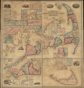
Map of the counties of Barnstable, Dukes and Nantucket, Massachusetts : based upon the trigonometrical survey of the state
65.
Atlas of the city of Boston : Boston proper and Back Bay
66.
Atlas of the city of Boston : Boston proper and Back Bay
67.
Atlas of the city of Boston : Boston proper and Roxbury
68.
Atlas of the city of Boston : Boston proper
69.
Atlas of the city of Boston : Boston proper and Back Bay
70.
Atlas of the city of Boston : Boston proper and Back Bay
71.
Atlas of the city of Boston : Boston proper and Back Bay
72.
Atlas of the county of Suffolk, Massachusetts, vol. 1 : including Boston proper
73.
Maps of the street-lines of Boston : made for the Selectmen in 1819 and 1820
74.
Plans of estates of William C. Barstow
75.
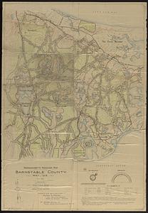
Massachusetts maneuver map : Barnstable County
76.
Atlas of Essex County, Massachusetts
77.
Atlas of the towns of Topsfield, Ipswich, Essex, Hamilton and Wenham, Essex County, Massachusetts : from official plans and...
78.
Map of Plymouth settled in 1620
79.
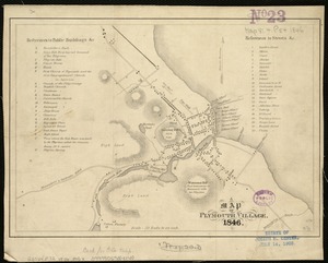
A map of Plymouth Village : 1846
80.
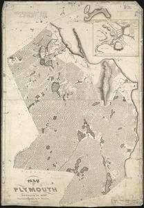
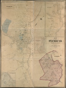
Map of the town of Plymouth : Plymouth Co. Mass. : from actual surveys
‹ Prev
Next ›
1
2
3
4
5
6
7
8
…
56
57