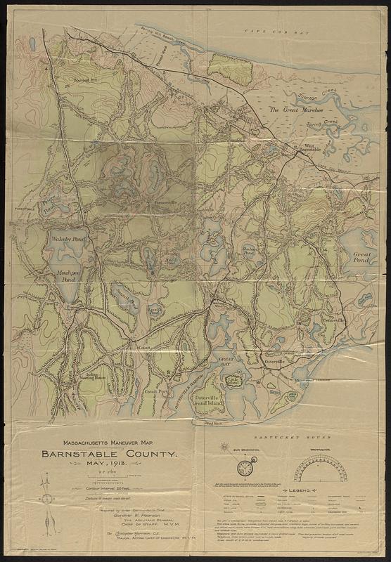
Massachusetts maneuver map : Barnstable County
Item Information
- Title:
- Massachusetts maneuver map : Barnstable County
- Issuing body:
- Massachusetts. Militia
- Cartographer:
- Harrison, Christopher
- Publisher:
- Walker Lith. & Pub. Co.
- Name on Item:
-
prepared by order Commander-in-Chief Gardner W. Pearson, the Adjutant General, Chief of Staff, M.V.M. ; by Christopher Harrison, C.E., Major, Acting Chief of Engineers, M.V.M.
- Date:
-
1913
- Format:
-
Maps/Atlases
- Location:
-
Boston Public Library
Norman B. Leventhal Map & Education Center - Collection (local):
-
Norman B. Leventhal Map & Education Center Collection
- Subjects:
-
Barnstable (Mass. : Town)--Maps
Mashpee (Mass. : Town)--Maps
Sandwich (Mass. : Town)--Maps
Trafficability--Massachusetts--Barnstable (Town)--Maps
Trafficability--Massachusetts--Mashpee (Town)--Maps
Trafficability--Massachusetts--Sandwich (Town)--Maps
- Places:
-
MassachusettsBarnstable (county)Barnstable
MassachusettsBarnstable (county)Mashpee
MassachusettsBarnstable (county)Sandwich
- Extent:
- 1 map : color ; 104 x 72 cm
- Terms of Use:
-
No known copyright restrictions.
No known restrictions on use.
- Publisher:
-
Boston :
Walker Lith. & Pub. Co.
- Scale:
-
Scale 1:21,120
- Language:
-
English
- Notes:
-
Relief shown by contours.
Covers the towns of Sandwich, Mashpee, and Barnstable.
Includes text and illustrations of sun orientation and a protractor.
Shows land cover and features.
- Identifier:
-
06_01_018743
- Call #:
-
G3763.B3P19 1913 .M37
- Barcode:
-
39999085970174