Toggle navigation
LMEC Home
Exhibitions
Georeferencing
Tools for Teachers
Collections
My Favorites
Sign Up / Log In
Search
Search the map portal
Map Collection
Map Collection
Map Sets
Search
Search
Search for
Search In
All Fields
Creator
Title
Subject
Place
Search All Digital Collections
Advanced Search
8930 Results
My Search
Start Over
More Like
commonwealth:cj82kz55w
Remove constraint More Like: commonwealth:cj82kz55w
Filter your Search
Place
North and Central America
6,161
United States
5,077
Massachusetts
2,142
Europe
1,396
Suffolk (county)
1,276
Boston
1,249
Canada
449
Asia
438
more
Place
»
Topic
Boston (Mass.)--Maps
752
United States--Maps
282
Real property--Massachusetts--Boston--Maps
253
City planning--Massachusetts--Boston--Maps
196
Landowners--Massachusetts--Boston--Maps
170
Massachusetts--Maps
166
New England--Maps
104
North America--Maps--Early works to 1800
103
more
Topic
»
Date
Date range begin
–
Date range end
Current results range from
1482
to
2023
View distribution
Creator
United States. Hydrographic Office
595
Boston Redevelopment Authority
202
O.H. Bailey & Co
148
Des Barres, Joseph F. W. (Joseph Frederick Wallet), 1722-1824
124
United States. Post Office Dept
120
Ptolemy, 2nd cent
100
Walling, Henry Francis, 1825-1888
94
Geological Survey (U.S.)
87
more
Creator
»
Format
Maps/Atlases
8,870
Manuscripts
214
Prints
56
Books
36
Objects/Artifacts
10
Drawings/Illustrations
8
Posters
5
Georeferenced
Yes
885
No
8,045
Collection
Norman B. Leventhal Map & Education Center Collection
8,724
Boston and New England Maps
2,400
Urban Maps
2,184
Maritime Charts and Atlases
1,083
American Revolutionary War-Era Maps
638
Boston Redevelopment Authority Collection
233
Massachusetts Real Estate Atlases
38
Mapping Boston Collection
20
more
Collection
»
Available to use
No known restrictions
8,707
Creative Commons license
70
Search Constraints
Sort by relevance
relevance
title
date (asc)
date (desc)
Number of results to display per page
20 per page
10
per page
20
per page
50
per page
100
per page
View results as:
grid view
map view
Search Results
421.
Metropolitan Transit Authority system route map
422.
[Mill dam survey : Boston, Roxbury, Brookline &c.]
423.
Most popular mode of commuting : 2014-2018 American Community Survey
424.
Motor routes that intersect the Bay Circuit
425.
Nanitz' great mercantile map of Boston
426.
Neighborhoods of Boston
427.
A new & complete map of the city of Boston, and precincts including part of Charlestown, Cambridge & Roxbury : from the best...
428.
A new & complete map of the city of Boston, and precincts including part of Charlestown, Cambridge & Roxbury : from the best...
429.
A new & complete map of the city of Boston, with part of Charlestown, Cambridge & Roxbury : from the best authorities
430.
A new & complete map of the city of Boston, with part of Charlestown, Cambridge & Roxbury
431.
A new & complete map of the city of Boston, with part of Charlestown, Cambridge & Roxbury
432.
A new & complete map of the city of Boston, with part of Charlestown, Cambridge & Roxbury
433.
A new & complete map of the city of Boston, with part of Charlestown, Cambridge, Brookline, Dorchester &c
434.
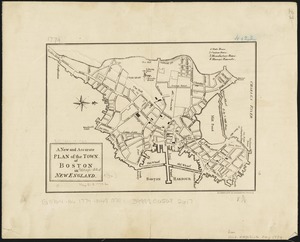
A new and accurate plan of the town of Boston in New England
435.
New Boston and Charles River Bay
436.
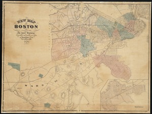
New map of Boston
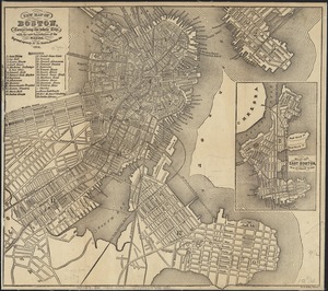
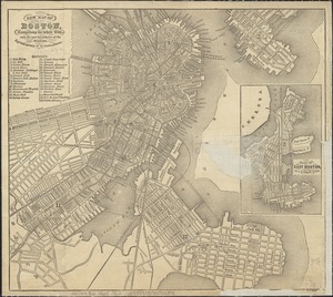
437.
New map of Boston, comprising the whole city, with the new boundaries of the wards
438.
New map of Boston, comprising the whole city, with the new boundaries of the wards
439.
New map of Boston, comprising the whole city, with the new boundaries of the wards
440.
New map of Boston, comprising the whole city, with the new boundaries of the wards
‹ Prev
Next ›
1
2
…
18
19
20
21
22
23
24
25
26
…
446
447