Toggle navigation
LMEC Home
Exhibitions
Georeferencing
Tools for Teachers
Collections
My Favorites
Sign Up / Log In
Search
Search the map portal
Map Collection
Map Collection
Map Sets
Search
Search
Search for
Search In
All Fields
Creator
Title
Subject
Place
Search All Digital Collections
Advanced Search
8755 Results
My Search
Start Over
More Like
commonwealth:cj82kt80d
Remove constraint More Like: commonwealth:cj82kt80d
Filter your Search
Place
North and Central America
5,986
United States
4,886
Massachusetts
2,085
Europe
1,396
Suffolk (county)
1,048
Boston
1,021
Canada
461
Asia
438
more
Place
»
Topic
Boston (Mass.)--Maps
588
United States--Maps
282
Real property--Massachusetts--Boston--Maps
175
Massachusetts--Maps
166
Landowners--Massachusetts--Boston--Maps
133
New England--Maps
127
North America--Maps--Early works to 1800
103
Europe--Maps
79
more
Topic
»
Date
Date range begin
–
Date range end
Current results range from
1482
to
2023
View distribution
Creator
United States. Hydrographic Office
595
O.H. Bailey & Co
148
Des Barres, Joseph F. W. (Joseph Frederick Wallet), 1722-1824
123
United States. Post Office Dept
120
Ptolemy, 2nd cent
100
Walling, Henry Francis, 1825-1888
94
Geological Survey (U.S.)
90
Jefferys, Thomas, -1771
86
more
Creator
»
Format
Maps/Atlases
8,695
Manuscripts
218
Prints
56
Books
36
Objects/Artifacts
10
Drawings/Illustrations
8
Posters
5
Georeferenced
Yes
870
No
7,885
Collection
Norman B. Leventhal Map & Education Center Collection
8,702
Boston and New England Maps
2,243
Urban Maps
2,023
Maritime Charts and Atlases
1,083
American Revolutionary War-Era Maps
663
Boston Redevelopment Authority Collection
87
American Antiquarian Society Collection
25
William L. Clements Library Collection
15
more
Collection
»
Available to use
No known restrictions
8,560
Creative Commons license
50
Search Constraints
Sort by relevance
relevance
title
date (asc)
date (desc)
Number of results to display per page
20 per page
10
per page
20
per page
50
per page
100
per page
View results as:
grid view
map view
Search Results
181.
An accurate map, of the district of Maine being part of the commonwealth of Massachusetts : compiled pursuant to an act of the...
182.
The coast from St. Johns, New Brunswick, to Goldsborough Bay, Maine
183.
The coast of Maine from modern Portland to Desert Island
184.
The district of Main from the latest surveys
185.
[Map of the area along the Saint Croix River in Maine and New Brunswick]
186.
Map of the District of Maine Massachusetts : compiled from actual surveys made by order of the General Court, and under the...
187.
A new map of the District of Maine : taken from the original map compiled by Osgood Carleton Esqr. : From the actual surveys...
188.
A new map of the district of Maine taken from the original map compiled by Osgood Carleton esqr. from the actual surveys that...
189.
A plan of a rout from Fort Pownall on the river Penobscot in New England to Quebec and from Quebec to Fort Pownall : taken by...
190.
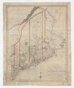
The Province of Maine, from the best authorities 1795
191.
Sketch of different passes into Canada from our lower provinces
192.
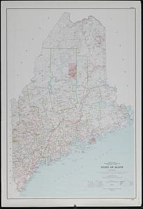
State of Maine
193.
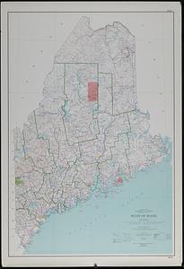
State of Maine : base map with highways and contours
194.
State of Maine : base map with highways and contours
195.
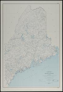
State of Maine : base map
196.
This plan represents par of the Bay of Passamoquoddy : the rivers Scoodic and Passamaquoddy which empty into said bay being an...
197.
This plan represents within the red lines twenty two townships of land situate between the million acres located on the River...
198.
Black in New England 1840
199.
Carte de la Nouvelle Angleterre, Nouvelle Yorck, et Pensilvanie. : Pour servir à l'Histoire générale des voyages
200.
Carte du theatre de la guerre presente en Amerique
‹ Prev
Next ›
1
2
…
6
7
8
9
10
11
12
13
14
…
437
438


![[Map of the area along the Saint Croix River in Maine and New Brunswick]](https://bpldcassets.blob.core.windows.net/derivatives/images/commonwealth:6108vt00n/image_thumbnail_300.jpg)