Toggle navigation
LMEC Home
Exhibitions
Georeferencing
Tools for Teachers
Collections
My Favorites
Sign Up / Log In
Search
Search the map portal
Map Collection
Map Collection
Map Sets
Search
Search
Search for
Search In
All Fields
Creator
Title
Subject
Place
Search All Digital Collections
Advanced Search
8184 Results
My Search
Start Over
More Like
commonwealth:cj82kn91w
Remove constraint More Like: commonwealth:cj82kn91w
Filter your Search
Place
North and Central America
4,933
United States
3,614
Suffolk (county)
1,028
Boston
1,001
Europe
963
Canada
433
France
269
Massachusetts
251
more
Place
»
Topic
Boston (Mass.)--Maps
576
United States--Maps
270
Real property--Massachusetts--Boston--Maps
174
Massachusetts--Maps
161
Landowners--Massachusetts--Boston--Maps
132
New England--Maps
120
North America--Maps--Early works to 1800
103
Europe--Maps
78
more
Topic
»
Date
Date range begin
–
Date range end
Current results range from
1482
to
2023
View distribution
Creator
United States. Hydrographic Office
357
O.H. Bailey & Co
148
Des Barres, Joseph F. W. (Joseph Frederick Wallet), 1722-1824
123
United States. Post Office Dept
120
Ptolemy, 2nd cent
100
Walling, Henry Francis, 1825-1888
94
Jefferys, Thomas, -1771
84
Geological Survey (U.S.)
82
more
Creator
»
Format
Maps/Atlases
8,125
Manuscripts
215
Prints
51
Books
36
Objects/Artifacts
10
Drawings/Illustrations
8
Posters
4
Georeferenced
Yes
871
No
7,313
Collection
Norman B. Leventhal Map Center Collection
8,165
Boston and New England Maps
2,188
Urban Maps
1,925
Maritime Charts and Atlases
750
American Revolutionary War-Era Maps
630
Boston Redevelopment Authority Collection
86
American Antiquarian Society Collection
9
Sidney R. Knafel Map Collection at Phillips Academy
4
more
Collection
»
Available to use
No known restrictions
8,024
Creative Commons license
49
Search Constraints
Sort by relevance
relevance
title
date (asc)
date (desc)
Number of results to display per page
20 per page
10
per page
20
per page
50
per page
100
per page
View results as:
grid view
map view
Search Results
41.
Railway map of the New England states, engraved expressly for the Pathfinder railway guide
42.
Sherman & Smith's rail road, steam boat & stage route map of New England, New-York, and Canada
43.
Sketch of the states of Massachusetts, Connecticut, and Rhode Island, and parts of New Hampshire & New York exhibiting the...
44.
Sketch of the states of Massachusetts, Connecticut, and Rhode Island, and parts of New Hampshire & New York exhibiting the...
45.
Summer resorts of the coast, lake, and mountain regions along the Boston & Maine Railroad and connections
46.
Telegraph and rail road map of the New England states
47.
Williams' telegraph and rail road map of the New England states, eastern portion of New York state and Canada
48.
Williams' telegraph and rail road map of the New England states, eastern protion of New York state and Canada : compiled from...
49.
Old Colony & Newport railway and its connections
50.
Diagram of rail roads diverging from Boston : showing the depots and distances
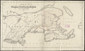
51.
Map of the European & North American Railway and its connections
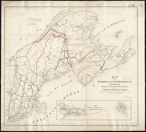
52.
Map of the European and North American Railway, showing its connection with the railways of the United States & Canada; made by...
53.
Map of the Hudson River & Berkshire R. R. and its connections
54.
Map showing the relative distances of Porsmouth [i.e. Portsmouth] and Boston from Concord & Manchester, N.H
55.
Travel-map of New England
56.
Automobile map of New England showing the ideal tour
57.
The Boston Globe ski map of northern New England and Canada
58.
A canoeist's guide to New England's rivers
59.
C.H. Guild & Co.'s newspaper map of New England
60.
The city of New York as laid out by the Commissioners with the surrounding country
‹ Prev
Next ›
1
2
3
4
5
6
7
…
409
410


![Map showing the relative distances of Porsmouth [i.e. Portsmouth] and Boston from Concord & Manchester, N.H](https://bpldcassets.blob.core.windows.net/derivatives/images/commonwealth:7h14b104z/image_thumbnail_300.jpg)


