Toggle navigation
LMEC Home
Exhibitions
Georeferencing
Tools for Teachers
Collections
My Favorites
Sign Up / Log In
Search
Search the map portal
Map Collection
Map Collection
Map Sets
Search
Search
Search for
Search In
All Fields
Creator
Title
Subject
Place
Search All Digital Collections
Advanced Search
8882 Results
My Search
Start Over
More Like
commonwealth:cc08kx48x
Remove constraint More Like: commonwealth:cc08kx48x
Filter your Search
Place
North and Central America
6,113
United States
5,029
Massachusetts
2,130
Europe
1,396
Suffolk (county)
1,228
Boston
1,201
Canada
449
Asia
438
more
Place
»
Topic
Boston (Mass.)--Maps
752
United States--Maps
282
Real property--Massachusetts--Boston--Maps
195
City planning--Massachusetts--Boston--Maps
176
Massachusetts--Maps
166
Landowners--Massachusetts--Boston--Maps
142
New England--Maps
104
North America--Maps--Early works to 1800
103
more
Topic
»
Date
Date range begin
–
Date range end
Current results range from
1482
to
2023
View distribution
Creator
United States. Hydrographic Office
595
Boston Redevelopment Authority
178
O.H. Bailey & Co
148
Des Barres, Joseph F. W. (Joseph Frederick Wallet), 1722-1824
124
United States. Post Office Dept
120
Ptolemy, 2nd cent
100
Walling, Henry Francis, 1825-1888
94
Geological Survey (U.S.)
87
more
Creator
»
Format
Maps/Atlases
8,822
Manuscripts
215
Prints
56
Books
36
Objects/Artifacts
10
Drawings/Illustrations
8
Posters
5
Georeferenced
Yes
885
No
7,997
Collection
Norman B. Leventhal Map & Education Center Collection
8,725
Boston and New England Maps
2,379
Urban Maps
2,161
Maritime Charts and Atlases
1,083
American Revolutionary War-Era Maps
638
Boston Redevelopment Authority Collection
210
Mapping Boston Collection
20
Massachusetts Real Estate Atlases
12
more
Collection
»
Available to use
No known restrictions
8,685
Creative Commons license
70
Search Constraints
Sort by relevance
relevance
title
date (asc)
date (desc)
Number of results to display per page
20 per page
10
per page
20
per page
50
per page
100
per page
View results as:
grid view
map view
Search Results
6401.
[Plan for proposed Charles River Park]
6402.
Plan for the construction of improvements at the Boston Common
6403.
Plan for the improvement of the Central Park, adopted by the Commissioners, June 3rd, 1856
6404.
Plan for the occupation of flats owned by the Commonwealth in Boston Harbor
6405.
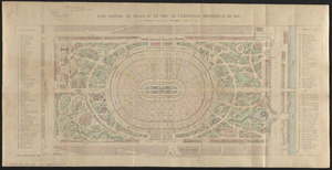
Plan général du palais et du parc de l'Exposition universelle de 1867
6406.
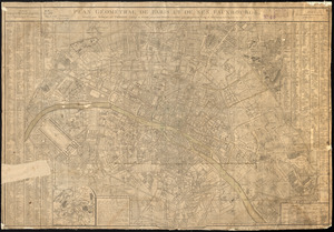
Plan géométral de Paris et de ses fauxbourgs
6407.
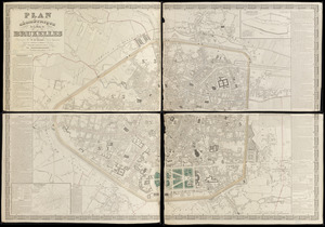
Plan géométrique de la ville de Bruxelles
6408.
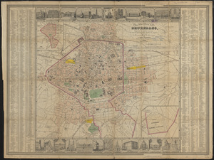
Plan illustré de la Ville de Bruxelles, comprenant les quartiers nouveaux & tous les agrandissements décrétés & projetés
6409.
Plan Moose River gold district, Halifax Co., N.S
6410.
Plan no. 1 of building lots near Spring St. Station West Roxbury belonging to the West Roxbury Land Co
6411.
Plan no II of land of George D. Welles situated in ward 16 Boston
6412.
Plan of 82 building lots, in the town of Brighton, comprising 48 acres of the Parkman Farm next the estate of Saml. Bigelow...
6413.
Plan of a part of Beverly in the Colony of the Massachusetts Bay
6414.
Plan of a part of Cambridge showing the location of the Fayerweather Estate
6415.
Plan of a part of New Brighton, Staten Island, showing the 500 blocks comprised in a proposed sale of lots
6416.
A plan of a survey of Noddles Island
6417.
A plan of Agawam
6418.
Plan of Amelia Island in East Florida : A chart of the entrance into St. Mary's River taken by Captn. W. Fuller in November,...
6419.
Plan of an estate in Boston belonging to Jos. Head Esqr
6420.
Plan of an estate in High St. to be sold at auction Sat. May 1st 1847 at 12 o'clock on the premises by Whitwell, Seaver & Co....
‹ Prev
Next ›
1
2
…
317
318
319
320
321
322
323
324
325
…
444
445
![[Plan for proposed Charles River Park]](https://bpldcassets.blob.core.windows.net/derivatives/images/commonwealth:cf95jc91c/image_thumbnail_300.jpg)