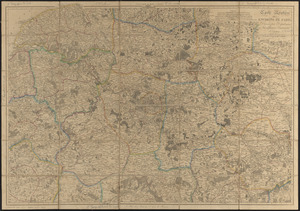
Plan général du palais et du parc de l'Exposition universelle de 1867

Item Information
- Title:
- Plan général du palais et du parc de l'Exposition universelle de 1867
- Cartographer:
- Frezouls
- Contributor:
- Broise
- Contributor:
- Bousquel
- Contributor:
- Thieffry
- Publisher:
- Briet & Perrée
- Name on Item:
-
par Frezouls, architecte, et Bousquel, ingénieur civil ; autographie Broise et Thieffry
- Date:
-
[1867]
- Format:
-
Maps/Atlases
- Location:
-
Boston Public Library
Norman B. Leventhal Map & Education Center - Collection (local):
-
Norman B. Leventhal Map & Education Center Collection
- Subjects:
-
Paris (France)--Maps
- Places:
-
FranceÎle-de-France (region)Paris
- Extent:
- 1 map : color ; 29 x 56 cm
- Terms of Use:
-
No known copyright restrictions.
No known restrictions on use.
- Publisher:
-
Paris :
Imp. Lith. Briet & Perrée
- Scale:
-
Scale 1:2,000
- Language:
-
French
- Notes:
-
Conservation of this piece funded by Lauren Roller and Cornelius Hardenbergh in honor of Jan and Gail Hardenbergh.
Oriented with north to the lower right.
Indexed.
- Notes (date):
-
This date is inferred.
- Identifier:
-
06_01_014205
- Call #:
-
G5834.P3:2E9 1867 .F74
- Barcode:
-
39999065700278