Toggle navigation
LMEC Home
Exhibitions
Georeferencing
Tools for Teachers
Collections
My Favorites
Sign Up / Log In
Search
Search the map portal
Map Collection
Map Collection
Map Sets
Search
Search
Search for
Search In
All Fields
Creator
Title
Subject
Place
Search All Digital Collections
Advanced Search
8875 Results
My Search
Start Over
More Like
commonwealth:9s161h45f
Remove constraint More Like: commonwealth:9s161h45f
Filter your Search
Place
North and Central America
6,106
United States
5,022
Massachusetts
2,132
Europe
1,396
Suffolk (county)
1,221
Boston
1,194
Canada
449
Asia
438
more
Place
»
Topic
Boston (Mass.)--Maps
752
United States--Maps
282
Real property--Massachusetts--Boston--Maps
199
City planning--Massachusetts--Boston--Maps
170
Massachusetts--Maps
166
Landowners--Massachusetts--Boston--Maps
143
New England--Maps
104
North America--Maps--Early works to 1800
103
more
Topic
»
Date
Date range begin
–
Date range end
Current results range from
1482
to
2023
View distribution
Creator
United States. Hydrographic Office
595
Boston Redevelopment Authority
175
O.H. Bailey & Co
148
Des Barres, Joseph F. W. (Joseph Frederick Wallet), 1722-1824
124
United States. Post Office Dept
120
Ptolemy, 2nd cent
100
Walling, Henry Francis, 1825-1888
94
Geological Survey (U.S.)
87
more
Creator
»
Format
Maps/Atlases
8,815
Manuscripts
215
Prints
56
Books
36
Objects/Artifacts
10
Drawings/Illustrations
8
Posters
5
Georeferenced
Yes
884
No
7,991
Collection
Norman B. Leventhal Map & Education Center Collection
8,723
Boston and New England Maps
2,371
Urban Maps
2,155
Maritime Charts and Atlases
1,083
American Revolutionary War-Era Maps
638
Boston Redevelopment Authority Collection
205
Mapping Boston Collection
20
Massachusetts Real Estate Atlases
12
more
Collection
»
Available to use
No known restrictions
8,678
Creative Commons license
70
Search Constraints
Sort by relevance
relevance
title
date (asc)
date (desc)
Number of results to display per page
20 per page
10
per page
20
per page
50
per page
100
per page
View results as:
grid view
map view
Search Results
1.
Plan of estates on Suffolk St. District : belonging to the City of Boston : to be sold at public auction, Dec. 23rd 1871
2.
Plan of estates on Suffolk St. district : belonging to the City of Boston : to be sold at public auction on Saturday Dec. 16th...
3.
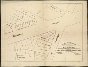
[Plan of lots in Chinatown (Boston), between Avery and Eliot Streets, and Tremont Street and Harrison Avenue]
4.
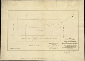
Plan of the estate of late Doct. John W. Warren, No. 89 Harrison Avenue, cor. of Kneeland St. & Plymouth Pl. to be sold at...
5.
Architectural styles, Chinatown historic core, historic edge
6.
Herald Street improvements
7.
Land use New York streets - South Cove 1953
8.
Relationship of TNEMC development plan area to New York streets land assembly and redevelopment project
9.
South Cove : property status and unit ownership
10.
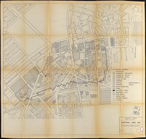
South Cove project no. Mass r- : existing land use
11.
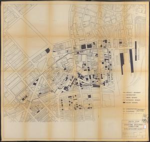
South Cove project no. Mass. r- : existing building condition
12.
South Cove property ownership 1950
13.
South Cove property ownership 1962
14.
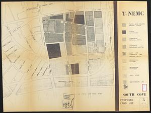
South Cove proposed land use
15.
South Cove urban renewal area Massachusetts R-92 : illustrative site plan
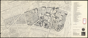
16.
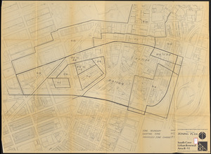
South Cove urban renewal area R-92 : zoning plan
17.
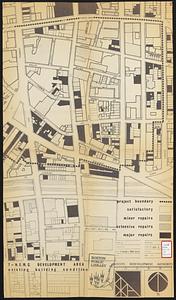
T-N.E.M.C. development area existing building condition
18.
T-N.E.M.C. properties acquired 1945-58
19.
Annexation map
20.
Atlas of the city of Boston : Boston proper : from actual surveys and official plans
‹ Prev
Next ›
1
2
3
4
5
…
443
444

![[Plan of lots in Chinatown (Boston), between Avery and Eliot Streets, and Tremont Street and Harrison Avenue]](https://bpldcassets.blob.core.windows.net/derivatives/images/commonwealth:cj82kz565/image_thumbnail_300.jpg)