Toggle navigation
LMEC Home
Exhibitions
Georeferencing
Tools for Teachers
Collections
My Favorites
Sign Up / Log In
Search
Search the map portal
Map Collection
Map Collection
Map Sets
Search
Search
Search for
Search In
All Fields
Creator
Title
Subject
Place
Search All Digital Collections
Advanced Search
8771 Results
My Search
Start Over
More Like
commonwealth:9s161g93w
Remove constraint More Like: commonwealth:9s161g93w
Filter your Search
Place
North and Central America
6,066
United States
4,988
Massachusetts
2,106
Europe
1,359
Suffolk (county)
1,251
Boston
1,224
Canada
448
Asia
422
more
Place
»
Topic
Boston (Mass.)--Maps
740
United States--Maps
273
Real property--Massachusetts--Boston--Maps
251
City planning--Massachusetts--Boston--Maps
186
Landowners--Massachusetts--Boston--Maps
168
Massachusetts--Maps
163
North America--Maps--Early works to 1800
103
New England--Maps
101
more
Topic
»
Date
Date range begin
–
Date range end
Current results range from
1482
to
2023
View distribution
Creator
United States. Hydrographic Office
594
Boston Redevelopment Authority
191
O.H. Bailey & Co
148
Des Barres, Joseph F. W. (Joseph Frederick Wallet), 1722-1824
124
United States. Post Office Dept
120
Ptolemy, 2nd cent
100
Walling, Henry Francis, 1825-1888
94
Geological Survey (U.S.)
87
more
Creator
»
Format
Maps/Atlases
8,712
Manuscripts
215
Prints
56
Books
36
Objects/Artifacts
10
Drawings/Illustrations
8
Posters
4
Georeferenced
Yes
885
No
7,886
Collection
Norman B. Leventhal Map & Education Center Collection
8,575
Boston and New England Maps
2,357
Urban Maps
2,086
Maritime Charts and Atlases
1,081
American Revolutionary War-Era Maps
638
Boston Redevelopment Authority Collection
223
Massachusetts Real Estate Atlases
38
Mapping Boston Collection
20
more
Collection
»
Available to use
No known restrictions
8,549
Creative Commons license
69
Search Constraints
Sort by relevance
relevance
title
date (asc)
date (desc)
Number of results to display per page
100 per page
10
per page
20
per page
50
per page
100
per page
View results as:
grid view
map view
Search Results
1.
Atlas of the city of Boston : Boston proper : from actual surveys and official plans
2.
Atlas of the city of Boston : Boston proper and Back Bay : from actual surveys and official plans
3.
Atlas of the city of Boston : Boston proper and Back Bay : from actual surveys and official plans
4.
Atlas of the city of Boston : Boston proper and Back Bay : from actual surveys and official plans
5.
Atlas of the city of Boston : Boston proper and Back Bay : from actual surveys and official plans
6.
Atlas of the city of Boston : Boston proper and Back Bay : from actual surveys and official plans
7.
Atlas of the city of Boston : Boston proper and Back Bay : from actual surveys and official plans
8.
Atlas of the city of Boston : Boston proper and Back Bay : from actual surveys and official plans
9.
Atlas of the city of Boston : Boston proper and Roxbury : from actual surveys and official plans
10.
Atlas of the city of Boston : city proper : volume 1 : from actual surveys and official records
11.
Atlas of the city of Boston : city proper and Roxbury : from actual surveys and official plans
12.
Atlas of the city of Boston : city proper, volume one : from actual surveys and official plans
13.
Atlas of the city of Boston : city proper, volume two : from actual surveys and official plans
14.
Atlas of the city of Boston : Roxbury : from actual surveys and official plans
15.
Atlas of the county of Suffolk, Massachusetts : vol. 1st including Boston proper : from actual surveys and official records
16.
Campus High School urban renewal area Mass. r-129 : property map
17.
City atlas of Boston, Massachusetts : complete in one volume : from official records, private plans and actual surveys
18.
Plan of an estate belonging to the City of Boston to be sold by public auction on Wednesday, Sept. 14th, 1881 ... : per order...
19.
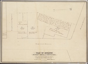
Plan of building lots on Phillips Place, Tremont & Somerset Streets
20.
Plan of building lots on Phillips Place, Tremont & Somerset Streets
21.
Plan of city lands to be sold Oct. 30th 1850
22.
Plan of City Wharf in Boston, Mass : shewing 14 lots of land on the side of the south dock of said wharf & Commercial St. : to...
23.
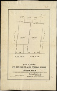
Plan of estate nos 207, 209, 211 & 215 Federal Street, belonging to the estate of the late Solomon Piper : to be sold at public...
24.
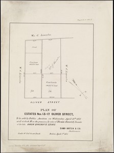
Plan of estates nos. 13-17 Oliver Street, to be sold by public auction on Wednesday April 12th 1871 at 12 o'clock m. on the...
25.
Plan of estates on Beacon St., Somerset St. & Pemberton Square : to be sold at auction by Whitwells & Seaver, on Thursday June...
26.
Plan of estates on Suffolk St. District : belonging to the City of Boston : to be sold at public auction, Dec. 23rd 1871
27.
[Plan of lots between Mount Vernon and Pinckney Streets in Boston]
28.
[Plan of lots for sale on Morton and Milk Streets, Boston]
29.
[Plan of lots for sale on Pearl Street in Boston]
30.
[Plan of lots in South Boston]
31.
[Plan of lots on Beacon Street and Somerset Court, Boston]
32.
Plan of lots on Fort Hill district, belonging to the City of Boston : to be sold at public auction, on Wednesday, April 15th at...
33.
[Plan of lots on Park, Beacon and Tremont Streets in Boston]
34.
Plan of Mercantile Wharf property in Boston Mass : showing 5 lots of land thereon to be sold at public auction on Tuesday April...
35.
[Plan of part of Boston bounded by Eliot, Washington, and Pleasant streets showing landownership in the late 17th century]
36.
Plan of Quincy House lot, corner of Brattle St. and Brattle Sq. belonging to the estate of Josiah Quincy Jr : to be sold by...
37.
Plan of site for new court house on Pemberton Sq. and Somerset St. for the County of Suffolk : taken by authority of Chapter 377
38.
Plan of the Brooks estate corner of Court & Washington Street : to be sold at public auction, at the Merchants Exchange Reading...
39.
Plan of the city of Boston
40.
Plan of the Federal St. Meeting House estate : to be sold by public auction, on Thursday February 24th 1859, at 12 o'clock noon...
41.
[Plan of the Gore Estate at the corner of Pitts and Green streets]
42.
Plan of the old Julien estate : compriseing [sic] two stores on Milk and Congress Streets : belonging to the estate of the late...
43.
Plan of the Pratt estate, corner of Summer & Hawley Streets : to be sold by pulic auction on Thursday April 10th 1855 at 12...
44.
Atlas of the city of Boston : Boston proper and Back Bay
45.
Atlas of the city of Boston : Boston proper and Back Bay
46.
Atlas of the city of Boston : Boston proper and Roxbury
47.
Atlas of the city of Boston : Boston proper
48.
Atlas of the city of Boston : Boston proper and Back Bay
49.
Atlas of the city of Boston : Boston proper and Back Bay
50.
Atlas of the city of Boston : Boston proper and Back Bay
51.
Atlas of the county of Suffolk, Massachusetts, vol. 1 : including Boston proper
52.
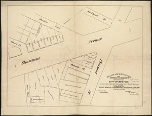
Plans of estates of William C. Barstow
53.
Boston urban wilds : ownership
54.
Historical map of the north and central parts of Old Boston : with explanatory key
55.
Plan of Boston showing existing ways and owners on December 25, 1630
56.
Plan of Boston showing existing ways and owners on December 25, 1631
57.
Plan of Boston showing existing ways and owners on December 25, 1632
58.
Plan of Boston showing existing ways and owners on December 25, 1633
59.
Plan of Boston showing existing ways and owners on December 25, 1634
60.
Plan of Boston showing existing ways and owners on December 25, 1636
61.
Plan of Boston showing existing ways and owners on December 25, 1637
62.
Plan of Boston showing existing ways and owners on December 25, 1638
63.
Plan of Boston showing existing ways and owners on December 25, 1639
64.
Plan of Boston showing existing ways and owners on December 25, 1640
65.
Plan of Boston showing existing ways and owners on December 25, 1641
66.
Plan of Boston showing existing ways and owners on December 25, 1642
67.
Plan of Boston showing existing ways and owners on December 25, 1643
68.
Plan of Boston showing existing ways and owners on December 25, 1644
69.
Plan of Boston showing existing ways and owners on December 25, 1645
70.
[Plan of boundary lines in Roxbury and the City of Boston]
71.
Plan of estates on Suffolk St. district : belonging to the City of Boston : to be sold at public auction on Saturday Dec. 16th...
72.
Plan of lands belonging to the Boston Water Power Company
73.
Atlas of Dorchester, West Roxbury and Brighton, city of Boston
74.
Atlas of Suffolk, county, vol. 7th, late town of Brighton, now ward 19 of Boston, Massachusetts : from actual survey & official...
75.
Atlas of the city of Boston : Brighton : from actual surveys and official plans
76.
Atlas of the city of Boston : Charlestown : from actual surveys and official plans
77.
Atlas of the city of Boston : Charlestown and Brighton, volume six : from actual surveys and official records
78.
Atlas of the city of Boston : Charlestown and East Boston : from actual surveys and official plans
79.
Atlas of the city of Boston : Charlestown and East Boston : from actual surveys and official plans
80.
Atlas of the city of Boston : Charlestown, Mass. : volume ten : from actual surveys and official plans
81.
Atlas of the city of Boston : Dorchester : from actual surveys and official plans
82.
Atlas of the city of Boston : Dorchester : from actual surveys and official plans
83.
Atlas of the city of Boston : Dorchester : from actual surveys and official plans
84.
Atlas of the city of Boston : Dorchester : volume three : from actual surveys and official records
85.
Atlas of the city of Boston : Dorchester, Mass., vol. 5 : from actual surveys and official plans
86.
Atlas of the city of Boston : Dorchester, Mass., vol. 5 : from actual surveys and official plans
87.
Atlas of the city of Boston : Dorchester, Mass., vol. 5 : from actual surveys and official plans
88.
Atlas of the city of Boston : East Boston : from actual surveys and official plans
89.
Atlas of the city of Boston : East Boston, Mass. : volume nine : from actual surveys and official plans
90.
Atlas of the city of Boston : Roxbury : from actual surveys and official plans
91.
Atlas of the city of Boston : Roxbury : from actual surveys and official plans
92.
Atlas of the city of Boston : Roxbury : from actual surveys and official plans
93.
Atlas of the city of Boston : Roxbury : volume two : from actual surveys and official records
94.
Atlas of the city of Boston : Roxbury, Mass. : volume four : from actual surveys and official records
95.
Atlas of the city of Boston : Roxbury, Mass. : volume three : from actual surveys and official records
96.
Atlas of the city of Boston : South & East Boston : volume four
97.
Atlas of the city of Boston : South Boston : from actual surveys and official plans
98.
Atlas of the city of Boston : South Boston : from actual surveys and official plans
99.
Atlas of the city of Boston : South Boston : from actual surveys and official plans
100.
Atlas of the city of Boston : volume 6 : West Roxbury : from actual surveys and official plans
‹ Prev
Next ›
1
2
3
4
5
…
87
88


![[Plan of lots between Mount Vernon and Pinckney Streets in Boston]](https://bpldcassets.blob.core.windows.net/derivatives/images/commonwealth:9s161h42m/image_thumbnail_300.jpg)
![[Plan of lots for sale on Morton and Milk Streets, Boston]](https://bpldcassets.blob.core.windows.net/derivatives/images/commonwealth:9s161h52v/image_thumbnail_300.jpg)
![[Plan of lots for sale on Pearl Street in Boston]](https://bpldcassets.blob.core.windows.net/derivatives/images/commonwealth:9s161h54d/image_thumbnail_300.jpg)
![[Plan of lots in South Boston]](https://bpldcassets.blob.core.windows.net/derivatives/images/commonwealth:9s161h046/image_thumbnail_300.jpg)
![[Plan of lots on Beacon Street and Somerset Court, Boston]](https://bpldcassets.blob.core.windows.net/derivatives/images/commonwealth:9s161h18j/image_thumbnail_300.jpg)

![[Plan of lots on Park, Beacon and Tremont Streets in Boston]](https://bpldcassets.blob.core.windows.net/derivatives/images/commonwealth:9s161j64v/image_thumbnail_300.jpg)

![[Plan of part of Boston bounded by Eliot, Washington, and Pleasant streets showing landownership in the late 17th century]](https://bpldcassets.blob.core.windows.net/derivatives/images/commonwealth:4m90fp141/image_thumbnail_300.jpg)


![[Plan of the Gore Estate at the corner of Pitts and Green streets]](https://bpldcassets.blob.core.windows.net/derivatives/images/commonwealth:9s161h402/image_thumbnail_300.jpg)


![[Plan of boundary lines in Roxbury and the City of Boston]](https://bpldcassets.blob.core.windows.net/derivatives/images/commonwealth:1257bb127/image_thumbnail_300.jpg)


