Toggle navigation
LMEC Home
Exhibitions
Georeferencing
Tools for Teachers
Collections
My Favorites
Sign Up / Log In
Search
Search the map portal
Map Collection
Map Collection
Map Sets
Search
Search
Search for
Search In
All Fields
Creator
Title
Subject
Place
Search All Digital Collections
Advanced Search
8594 Results
My Search
Start Over
More Like
commonwealth:9s161f25j
Remove constraint More Like: commonwealth:9s161f25j
Filter your Search
Place
North and Central America
5,889
United States
4,813
Massachusetts
2,052
Europe
1,359
Suffolk (county)
1,078
Boston
1,051
Canada
448
Asia
422
more
Place
»
Topic
Boston (Mass.)--Maps
579
United States--Maps
273
Real property--Massachusetts--Boston--Maps
185
Massachusetts--Maps
160
Landowners--Massachusetts--Boston--Maps
136
City planning--Massachusetts--Boston--Maps
104
North America--Maps--Early works to 1800
103
New England--Maps
99
more
Topic
»
Date
Date range begin
–
Date range end
Current results range from
1482
to
2023
View distribution
Creator
United States. Hydrographic Office
594
O.H. Bailey & Co
148
Des Barres, Joseph F. W. (Joseph Frederick Wallet), 1722-1824
123
United States. Post Office Dept
120
Boston Redevelopment Authority
107
Ptolemy, 2nd cent
100
Walling, Henry Francis, 1825-1888
94
Geological Survey (U.S.)
86
more
Creator
»
Format
Maps/Atlases
8,535
Manuscripts
215
Prints
56
Books
36
Objects/Artifacts
10
Drawings/Illustrations
8
Posters
4
Georeferenced
Yes
869
No
7,725
Collection
Norman B. Leventhal Map & Education Center Collection
8,550
Boston and New England Maps
2,244
Urban Maps
1,976
Maritime Charts and Atlases
1,081
American Revolutionary War-Era Maps
616
Boston Redevelopment Authority Collection
127
Massachusetts Real Estate Atlases
4
Mapping Boston Collection
1
Available to use
No known restrictions
8,448
Creative Commons license
47
Search Constraints
Sort by relevance
relevance
title
date (asc)
date (desc)
Number of results to display per page
20 per page
10
per page
20
per page
50
per page
100
per page
View results as:
grid view
map view
Search Results
2261.
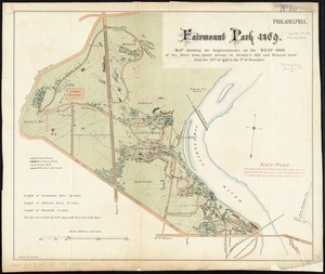
Fairmount Park 1869 : map showing the improvements on the west-side of the river from Girard Avenue to George's Hill and...
2262.
Fairmount Park, Philadelphia, 1868 : with limits, as prescribed in Act of Assembly, approved March 26th, 1868 : showing the...
2263.
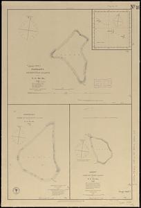
Fakaafo or Bowditch Island ; Nuku-Nono or Duke of Clarence Island ; Oatáfu or Duke of York Island
2264.
Fakaafo or Bowditch Island ; Nuku-Nono or Duke of Clarence Island ; Oatáfu or Duke of York Island
2265.
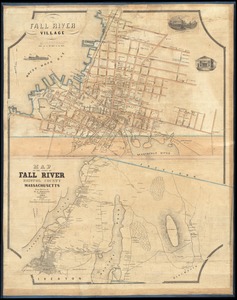
Fall River Village ; Map of the town of Fall River, Bristol County, Massachusetts
2266.
Falmouth Harbour
2267.
Falmouth Harbour
2268.
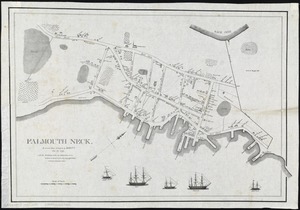
Falmouth Neck : as it was when destroyed by Mowett, Oct. 18, 1775
2269.
Fangaloa Bay, north side of Upolu
2270.
Fault map of the state of California
2271.
Fayal Id., Horta and Pim Bays ; Azores, Fayal Channel
2272.
Fes
2273.
Fezzae et Marocchi regna Africae celeberrima
2274.
Field of operations of the Army of the Potomac
2275.
The fifteenth section no. I. Lake Huron 1820 & 1822
2276.
The fifth column menaces America on a thousand fronts
2277.
Financial irrigation of the United States by funds appropriated for emergency use under the New Deal
2278.
Fire insurance district atlas : showing the fire insurance districts of the city of Boston : as established by the State...
2279.
The Firemen's guide : a map of the City of New-York, showing the fire districts, fire limits, hydrants, public cisterns,...
2280.
First Corps Cadets, Massachusetts Volunteer Militia : encampment at Hingham, July 13 to 18, 1885
‹ Prev
Next ›
1
2
…
110
111
112
113
114
115
116
117
118
…
429
430