Toggle navigation
LMEC Home
Exhibitions
Georeferencing
Tools for Teachers
Collections
My Favorites
Sign Up / Log In
Search
Search the map portal
Map Collection
Map Collection
Map Sets
Search
Search
Search for
Search In
All Fields
Creator
Title
Subject
Place
Search All Digital Collections
Advanced Search
8700 Results
My Search
Start Over
More Like
commonwealth:9g54xm206
Remove constraint More Like: commonwealth:9g54xm206
Filter your Search
Place
North and Central America
5,931
United States
4,847
Massachusetts
2,078
Europe
1,396
Suffolk (county)
1,045
Boston
1,018
Canada
455
Asia
438
more
Place
»
Topic
Boston (Mass.)--Maps
586
United States--Maps
282
Real property--Massachusetts--Boston--Maps
175
Massachusetts--Maps
162
Landowners--Massachusetts--Boston--Maps
133
North America--Maps--Early works to 1800
103
New England--Maps
102
Europe--Maps
79
more
Topic
»
Date
Date range begin
–
Date range end
Current results range from
1482
to
2023
View distribution
Creator
United States. Hydrographic Office
595
O.H. Bailey & Co
148
Des Barres, Joseph F. W. (Joseph Frederick Wallet), 1722-1824
122
United States. Post Office Dept
120
Ptolemy, 2nd cent
100
Walling, Henry Francis, 1825-1888
94
Jefferys, Thomas, -1771
87
Geological Survey (U.S.)
86
more
Creator
»
Format
Maps/Atlases
8,640
Manuscripts
215
Prints
56
Books
36
Objects/Artifacts
10
Drawings/Illustrations
8
Posters
5
Georeferenced
Yes
869
No
7,831
Collection
Norman B. Leventhal Map & Education Center Collection
8,694
Boston and New England Maps
2,232
Urban Maps
2,023
Maritime Charts and Atlases
1,083
American Revolutionary War-Era Maps
620
Boston Redevelopment Authority Collection
87
Richard H. Brown Revolutionary War Map Collection at Mount Vernon
3
Boston Athenaeum, Cartographic Collection
1
more
Collection
»
Available to use
No known restrictions
8,551
Creative Commons license
53
Search Constraints
Sort by relevance
relevance
title
date (asc)
date (desc)
Number of results to display per page
20 per page
10
per page
20
per page
50
per page
100
per page
View results as:
grid view
map view
Search Results
7721.
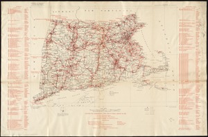
Stations and transmission lines used in public service in 1919 : [Massachusetts, Rhode Island, and Connecticut]
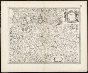
7722.
Stato di Milano
7723.
Lo Stato Veneto da terra diviso nelle sue provincie : seconda parte che comprede porzioni del Dogado del Trevisano del Friuli e...
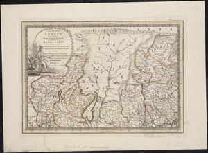
7724.
Lo Stato Veneto da terra diviso nelle sue provincie : prima parte che comprende Il Bergamasco Il Cremasco Il Feltrino Il...
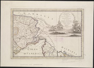
7725.
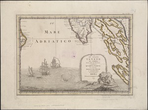
Lo Stato Veneto da terra diviso nelle sue provincie : quarta parte che compren de porzioni del Dogado e dell' Istria
7726.
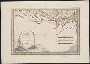
Lo Stato Veneto da terra diviso nelle sue provincie : terza parte che comprende il polesine e porzioni del Bresciano Veronese...
7727.
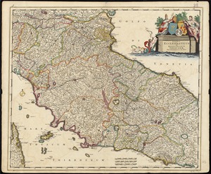
Status ecclesiasticus et magnus ducatus Thoscanae
7728.
Steam railroads in Boston 1888
7729.
Steden Wyser synde een perfecte en klare aenwysinge ... Leggen = L'echelle des villes montrant la distance ... l'autre
7730.
Storrow Memorial Embankment : plan of additions and changes under the requirements of Chapter 262, Acts of 1949
7731.
The story map of flying : being a chronicle of man's conquest of the air
7732.
Stoughton, Mass : 1879
7733.
Stoughton, Massachusetts : 1890
7734.
Stovel's map of Winnipeg, including St. Boniface and surrounding suburbs
7735.
Strait of Gibraltar : from the most recent surveys
7736.
Straits of Mackinac with the approaches thereto from Lakes Huron and Michigan and the entrance by the Détour Passage to the...
7737.
The Straits of Seniavine, Behring's Straits
7738.
The Straits of Seniavine, Behring's Straits
7739.
Straits of Tsugar, Japan : surveyed in the U.S. Str. John Hancock, 1855
7740.
The strangers mercantile guide map of the cities of New York, Brooklyn, Jersey City, Hoboken, etc
‹ Prev
Next ›
1
2
…
383
384
385
386
387
388
389
390
391
…
434
435