Toggle navigation
LMEC Home
Exhibitions
Georeferencing
Tools for Teachers
Collections
My Favorites
Sign Up / Log In
Search
Search the map portal
Map Collection
Map Collection
Map Sets
Search
Search
Search for
Search In
All Fields
Creator
Title
Subject
Place
Search All Digital Collections
Advanced Search
8698 Results
My Search
Start Over
More Like
commonwealth:9g54xk78d
Remove constraint More Like: commonwealth:9g54xk78d
Filter your Search
Place
North and Central America
5,930
United States
4,846
Massachusetts
2,078
Europe
1,396
Suffolk (county)
1,045
Boston
1,018
Canada
454
Asia
438
more
Place
»
Topic
Boston (Mass.)--Maps
586
United States--Maps
282
Real property--Massachusetts--Boston--Maps
175
Massachusetts--Maps
162
Landowners--Massachusetts--Boston--Maps
133
North America--Maps--Early works to 1800
103
New England--Maps
102
Europe--Maps
79
more
Topic
»
Date
Date range begin
–
Date range end
Current results range from
1482
to
2023
View distribution
Creator
United States. Hydrographic Office
595
O.H. Bailey & Co
148
Des Barres, Joseph F. W. (Joseph Frederick Wallet), 1722-1824
122
United States. Post Office Dept
120
Ptolemy, 2nd cent
100
Walling, Henry Francis, 1825-1888
94
Jefferys, Thomas, -1771
87
Geological Survey (U.S.)
86
more
Creator
»
Format
Maps/Atlases
8,638
Manuscripts
215
Prints
56
Books
36
Objects/Artifacts
10
Drawings/Illustrations
8
Posters
5
Georeferenced
Yes
869
No
7,829
Collection
Norman B. Leventhal Map & Education Center Collection
8,694
Boston and New England Maps
2,232
Urban Maps
2,023
Maritime Charts and Atlases
1,083
American Revolutionary War-Era Maps
618
Boston Redevelopment Authority Collection
87
Richard H. Brown Revolutionary War Map Collection at Mount Vernon
2
Harvard Map Collection
1
more
Collection
»
Available to use
No known restrictions
8,551
Creative Commons license
51
Search Constraints
Sort by relevance
relevance
title
date (asc)
date (desc)
Number of results to display per page
20 per page
10
per page
20
per page
50
per page
100
per page
View results as:
grid view
map view
Search Results
1.
Canso Harbor
2.
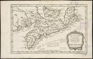
Carte de l'Acadie, Isle Royale, et Païs Voisins : pour servir à l'Histoire Générale des voyages
3.
Charlotte Bay
4.
A chart of Nova Scotia
5.
Coast of Nova Scotia from Barrington Bay to Cape Blancherolte
6.
Coast of Nova Scotia from Barrington Bay to Cape Blancherolte
7.
Conway Harbour : Port Aylesbury
8.
Crow Harbour : on the south shore of Chedabuctou Bay
9.
A draught of the harbour of Hallifax and the adjacent coast in Nova Scotia
10.
Egmont Harbor
11.
Frederick Bay ... : Ramsheg Harbour ... Pictou Harbour ... Port Luttrell
12.
The Gut of Canso : which divides ... cables distance
13.
Halifax Harbour ... Catch Harbour ... small vessels only
14.
Halifax Harbour ... Catch Harbour ... small vessels only
15.
Keppell Harbour : Knowles Harbour ; Tangier Harbour ; Saunder's Harbour ; Deane Harbour
16.
King's Bay ... : Lunenburg
17.
Leith Harbour ... : Prospect Harbour ... Bristol Bay ... Sambro Harbour
18.
[Lennox Passage region]
19.
Liverpool Bay
20.
Map of Nova Scotia, or Acadia : with the islands of Cape Breton and St. John's, from actual surveys
‹ Prev
Next ›
1
2
3
4
5
…
434
435


![[Lennox Passage region]](https://bpldcassets.blob.core.windows.net/derivatives/images/commonwealth:ws859h17t/image_thumbnail_300.jpg)

