Toggle navigation
LMEC Home
Exhibitions
Georeferencing
Tools for Teachers
Collections
My Favorites
Sign Up / Log In
Search
Search the map portal
Map Collection
Map Collection
Map Sets
Search
Search
Search for
Search In
All Fields
Creator
Title
Subject
Place
Search All Digital Collections
Advanced Search
9052 Results
My Search
Start Over
More Like
commonwealth:7d27c9549
Remove constraint More Like: commonwealth:7d27c9549
Filter your Search
Place
North and Central America
6,283
United States
5,201
Massachusetts
2,155
Suffolk (county)
1,403
Europe
1,396
Boston
1,376
Canada
449
Asia
438
more
Place
»
Topic
Boston (Mass.)--Maps
677
City planning--Massachusetts--Boston--Maps
418
United States--Maps
282
Urban renewal--Massachusetts--Boston--Maps
252
Real property--Massachusetts--Boston--Maps
217
Massachusetts--Maps
162
Landowners--Massachusetts--Boston--Maps
136
North America--Maps--Early works to 1800
103
more
Topic
»
Date
Date range begin
–
Date range end
Current results range from
1482
to
2023
View distribution
Creator
United States. Hydrographic Office
595
Boston Redevelopment Authority
390
O.H. Bailey & Co
148
Des Barres, Joseph F. W. (Joseph Frederick Wallet), 1722-1824
123
United States. Post Office Dept
120
Ptolemy, 2nd cent
100
Walling, Henry Francis, 1825-1888
94
Geological Survey (U.S.)
86
more
Creator
»
Format
Maps/Atlases
8,991
Manuscripts
215
Prints
56
Books
36
Objects/Artifacts
10
Drawings/Illustrations
9
Posters
5
Georeferenced
Yes
870
No
8,182
Collection
Norman B. Leventhal Map & Education Center Collection
8,696
Boston and New England Maps
2,586
Urban Maps
2,373
Maritime Charts and Atlases
1,083
American Revolutionary War-Era Maps
620
Boston Redevelopment Authority Collection
438
William L. Clements Library Collection
3
Mapping Boston Collection
2
more
Collection
»
Available to use
No known restrictions
8,904
Creative Commons license
49
Search Constraints
Sort by relevance
relevance
title
date (asc)
date (desc)
Number of results to display per page
20 per page
10
per page
20
per page
50
per page
100
per page
View results as:
grid view
map view
Search Results
7281.
Profile of Huntington Avenue/St. James Avenue from Harcourt Street to Berkeley Street
7282.
Profile of the river St. Lawrence between Montreal and Quebec shewing the deepening of the ship channel
7283.
Progress chart of the Survey of the Northern & North Western Lakes, July 1st, 1873 : primary triangulation, telegraphic...
7284.
Progress map of Signal Corps telegraph lines & cables in the military division of the Philippines : based on map of Montero y...
7285.
Progress map of Signal Corps telegraph lines & cables in the military division of the Philippines : based on map of Montero y...
7286.
Progress of construction, government railroad, Alaska
7287.
Property atlas of city of Lowell, northern district, Middlesex County, Massachusetts, showing the entire city complete in one...
7288.
Property qualifications for suffrage, 1775
7289.
Property qualifications for suffrage, 1800
7290.
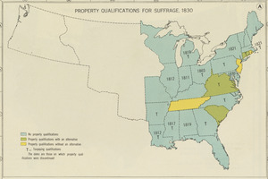
Property qualifications for suffrage, 1830
7291.
Property qualifications for suffrage, 1860
7292.
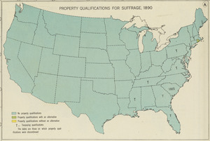
Property qualifications for suffrage, 1890
7293.
Property qualifications for suffrage, 1920
7294.
Proportion of units where rent costs over 30% of resident's income
7295.
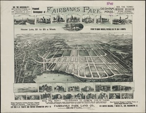
Proposed development of Fairbanks Park, Dedham, Mass
7296.
Proposed park system from the Common to the West Roxbury Park including the Back Bay and Muddy river improvements, Jamaica Pond...
7297.
Proposed parks and parkways
7298.
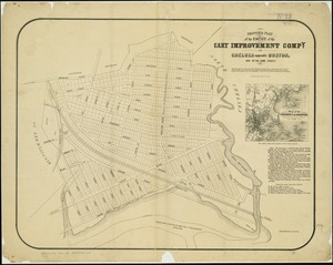
Proposed plan of the estate of the Cary Improvement Compy : in Chelsea opposite Boston, and in the same county
7299.
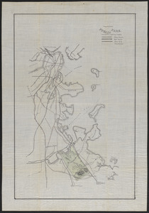
Proposed public park and routes leading thereto
7300.
Proposed route of the Boston and Mystic Valley railroad
‹ Prev
Next ›
1
2
…
361
362
363
364
365
366
367
368
369
…
452
453