Toggle navigation
LMEC Home
Exhibitions
Georeferencing
Tools for Teachers
Collections
My Favorites
Sign Up / Log In
Search
Search the map portal
Map Collection
Map Collection
Map Sets
Search
Search
Search for
Search In
All Fields
Creator
Title
Subject
Place
Search All Digital Collections
Advanced Search
9053 Results
My Search
Start Over
More Like
commonwealth:7940bf647
Remove constraint More Like: commonwealth:7940bf647
Filter your Search
Place
North and Central America
6,284
United States
5,202
Massachusetts
2,152
Suffolk (county)
1,404
Europe
1,396
Boston
1,377
Canada
449
Asia
438
more
Place
»
Topic
Boston (Mass.)--Maps
679
City planning--Massachusetts--Boston--Maps
418
United States--Maps
282
Urban renewal--Massachusetts--Boston--Maps
253
Real property--Massachusetts--Boston--Maps
217
Massachusetts--Maps
162
Landowners--Massachusetts--Boston--Maps
135
North America--Maps--Early works to 1800
103
more
Topic
»
Date
Date range begin
–
Date range end
Current results range from
1482
to
2023
View distribution
Creator
United States. Hydrographic Office
595
Boston Redevelopment Authority
392
O.H. Bailey & Co
148
Des Barres, Joseph F. W. (Joseph Frederick Wallet), 1722-1824
123
United States. Post Office Dept
120
Ptolemy, 2nd cent
100
Walling, Henry Francis, 1825-1888
94
Geological Survey (U.S.)
86
more
Creator
»
Format
Maps/Atlases
8,993
Manuscripts
215
Prints
56
Books
36
Objects/Artifacts
10
Drawings/Illustrations
8
Posters
5
Georeferenced
Yes
870
No
8,183
Collection
Norman B. Leventhal Map & Education Center Collection
8,696
Boston and New England Maps
2,591
Urban Maps
2,377
Maritime Charts and Atlases
1,083
American Revolutionary War-Era Maps
616
Boston Redevelopment Authority Collection
443
Applied Geographics, Inc. Records
1
Available to use
No known restrictions
8,911
Creative Commons license
47
Search Constraints
Sort by relevance
relevance
title
date (asc)
date (desc)
Number of results to display per page
20 per page
10
per page
20
per page
50
per page
100
per page
View results as:
grid view
map view
Search Results
6681.
A plan of Port Royal harbour in Carolina with the proposed forts, depth of water &c
6682.
A plan of Port Royal in South Carolina
6683.
Plan of portion of park system from Common to Franklin Park : including Charles River Basin, Charlesbank, Commonwealth Avenue,...
6684.
Plan of properties at Galloupe's Point : Swampscott, Mass.
6685.
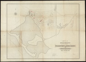
Plan of property belonging to the Pocasset Grove and Shore Company, at Cataumet, South Pocasset, Mass
6686.
[Plan of property in the Cambridgeport marshes]
6687.
Plan of property of the National Dock & Warehouse Co. East Boston
6688.
Plan of proposed Marginal Street from Broad Street at Rowe's Wharf to Commercial Street at Eastern Avenue : showing adjacent...
6689.
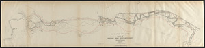
Plan of proposed Muddy River improvement, showing contours : July 23, 1881
6690.
Plan of Public Garden : showing proposed arrangement of lots thereon
6691.
Plan of Public library lot
6692.
Plan of Puerto Cavello, on the coast of the Caracas ; Plan of Puerto de La Guaira on the coast of the Caracas
6693.
A plan of Quebec
6694.
A plan of Quebec and environs, with its defences and the occasional entrenched camps of the French commanded by Marquis de...
6695.
A plan of Quebec the capital of New France or Canada
6696.
Plan of Quincy House lot, corner of Brattle St. and Brattle Sq. belonging to the estate of Josiah Quincy Jr : to be sold by...
6697.
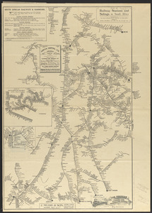
Plan of railway stations and sidings in South Africa
6698.
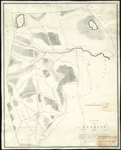
Plan of Reading, Mass
6699.
Plan of real estate belonging to T.W. & J.H. Cox : situated in ward 16, Boston
6700.
Plan of real estate in Charlestown belonging to Seth Barker & others : to be sold on the premises at public auction, June 26th,...
‹ Prev
Next ›
1
2
…
331
332
333
334
335
336
337
338
339
…
452
453


![[Plan of property in the Cambridgeport marshes]](https://bpldcassets.blob.core.windows.net/derivatives/images/commonwealth:1257bb747/image_thumbnail_300.jpg)