Toggle navigation
LMEC Home
Exhibitions
Georeferencing
Tools for Teachers
Collections
My Favorites
Sign Up / Log In
Search
Search the map portal
Map Collection
Map Collection
Map Sets
Search
Search
Search for
Search In
All Fields
Creator
Title
Subject
Place
Search All Digital Collections
Advanced Search
8171 Results
My Search
Start Over
More Like
commonwealth:6t053r92b
Remove constraint More Like: commonwealth:6t053r92b
Filter your Search
Place
North and Central America
4,916
United States
3,746
Suffolk (county)
1,026
Boston
999
Europe
963
Canada
427
Massachusetts
294
France
269
more
Place
»
Topic
Boston (Mass.)--Maps
574
United States--Maps
270
Real property--Massachusetts--Boston--Maps
174
Massachusetts--Maps
160
Landowners--Massachusetts--Boston--Maps
132
North America--Maps--Early works to 1800
106
New England--Maps
99
Europe--Maps
78
more
Topic
»
Date
Date range begin
–
Date range end
Current results range from
1482
to
2023
View distribution
Creator
United States. Hydrographic Office
357
O.H. Bailey & Co
148
Des Barres, Joseph F. W. (Joseph Frederick Wallet), 1722-1824
123
United States. Post Office Dept
120
Ptolemy, 2nd cent
100
Walling, Henry Francis, 1825-1888
94
Jefferys, Thomas, -1771
86
Geological Survey (U.S.)
82
more
Creator
»
Format
Maps/Atlases
8,112
Manuscripts
218
Prints
51
Books
36
Objects/Artifacts
10
Drawings/Illustrations
8
Posters
4
Georeferenced
Yes
869
No
7,302
Collection
Norman B. Leventhal Map Center Collection
8,162
Boston and New England Maps
2,184
Urban Maps
1,925
Maritime Charts and Atlases
750
American Revolutionary War-Era Maps
623
Boston Redevelopment Authority Collection
86
Richard H. Brown Revolutionary War Map Collection at Mount Vernon
4
Newberry Library Collection
2
more
Collection
»
Available to use
No known restrictions
8,021
Creative Commons license
52
Search Constraints
Sort by relevance
relevance
title
date (asc)
date (desc)
Number of results to display per page
20 per page
10
per page
20
per page
50
per page
100
per page
View results as:
grid view
map view
Search Results
41.
A new and improved chart of the West India or Carribbee [sic] Islands
42.
A new chart of the Bahama Islands and the Windward Passage
43.
A new chart of the West Indies including the Florida Gulf and Stream
44.
A new general chart of the West Indies from the latest marine journals and srveys regulated and ascertained by astronomical...
45.
A new general chart of the West Indies from the latest marine journals and surveys regulated and ascertained by astronomical...
46.
A new general chart of the West Indies from the latest marine journals and surveys regulated and ascertained by astronomical...
47.
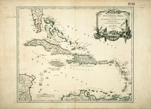
Partie de la mer du Nord, où se trouvent les grandes et petites isles Antilles, et les isles Lucayes
48.
Pascaerte van Brazil en Nieu Nederlandt, van Corvo en Flores tot de Barbados
49.
The principall islands in America belonging to the English empire viz Iamaica, Barbados, Antegoa, St. Christophers & Bermudos
50.
Teâtre de la guerre en Amerique telle que'elle est à present possedée par les Espagnols, Anglois, François, et Hollandois...
51.
Terra Firma and the Caribbé Islands &c
52.
The West Indies
53.
West Indies
54.
The West Indies and coast adjacent : reduced from the sheet map
55.
West-Indische paskaert : waer in de graden der breedde over weder zyden vande middellyn wassende soo vergroten dat die...
56.
Zeilan Insula
57.
Map of the Caribbean Area
58.
Carte du Cap Franc̨ois de Saint Domingue, de l'isle de Cuba, de la Jamaique avec le canal de Bahama, l'entrée du fleuve St....
59.
Chart of South America, comprehending the West Indies, with the adjacent islands, in the Southern Ocean, and South Sea
60.
Chart of the Atlantic Ocean, with the British, French, & Spanish settlements in North America, and the West Indies : as also on...
‹ Prev
Next ›
1
2
3
4
5
6
7
…
408
409
![A new and improved chart of the West India or Carribbee [sic] Islands](https://bpldcassets.blob.core.windows.net/derivatives/images/commonwealth:kk91fq95z/image_thumbnail_300.jpg)