Toggle navigation
LMEC Home
Exhibitions
Georeferencing
Tools for Teachers
Collections
My Favorites
Sign Up / Log In
Search
Search the map portal
Map Collection
Map Collection
Map Sets
Search
Search
Search for
Search In
All Fields
Creator
Title
Subject
Place
Search All Digital Collections
Advanced Search
8775 Results
My Search
Start Over
More Like
commonwealth:6t053p17c
Remove constraint More Like: commonwealth:6t053p17c
Filter your Search
Place
North and Central America
6,006
United States
4,916
Massachusetts
2,092
Europe
1,396
Suffolk (county)
1,048
Boston
1,021
Canada
458
Asia
438
more
Place
»
Topic
Boston (Mass.)--Maps
587
United States--Maps
282
Real property--Massachusetts--Boston--Maps
175
Massachusetts--Maps
162
Landowners--Massachusetts--Boston--Maps
133
North America--Maps--Early works to 1800
106
New England--Maps
102
New England--Maps--Early works to 1800
97
more
Topic
»
Date
Date range begin
–
Date range end
Current results range from
1482
to
2023
View distribution
Creator
United States. Hydrographic Office
595
O.H. Bailey & Co
148
Des Barres, Joseph F. W. (Joseph Frederick Wallet), 1722-1824
123
United States. Post Office Dept
120
Ptolemy, 2nd cent
100
Walling, Henry Francis, 1825-1888
94
Jefferys, Thomas, -1771
88
Geological Survey (U.S.)
86
more
Creator
»
Format
Maps/Atlases
8,715
Manuscripts
218
Prints
56
Books
36
Objects/Artifacts
10
Drawings/Illustrations
8
Posters
5
Georeferenced
Yes
876
No
7,899
Collection
Norman B. Leventhal Map & Education Center Collection
8,720
Boston and New England Maps
2,246
Urban Maps
2,023
Maritime Charts and Atlases
1,086
American Revolutionary War-Era Maps
664
Boston Redevelopment Authority Collection
87
Mapping Boston Collection
24
Sidney R. Knafel Map Collection at Phillips Academy
20
more
Collection
»
Available to use
No known restrictions
8,555
Creative Commons license
92
Search Constraints
Sort by relevance
relevance
title
date (asc)
date (desc)
Number of results to display per page
20 per page
10
per page
20
per page
50
per page
100
per page
View results as:
grid view
map view
Search Results
2441.
Frank Leslie's war maps and companion to the newspaper
2442.
Franklin and Franklin Falls, N.H : Merrimack County, 1884
2443.
Franklin, Massachusetts
2444.
Franklin Park general plan for zoological garden
2445.
Frankreich
2446.
[Frantia]
2447.
Frederick Bay ... : Ramsheg Harbour ... Pictou Harbour ... Port Luttrell
2448.
The Fred'k A. Schmidt Co. map of metropolitan Cincinnati
2449.
Fredonia or the United States of North-America : including also Cabotia, or the Canadian provinces; the Western Territory to...
2450.
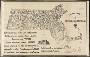
Free public libraries of Massachusetts
2451.
French Morocco port traffic, 1938
2452.
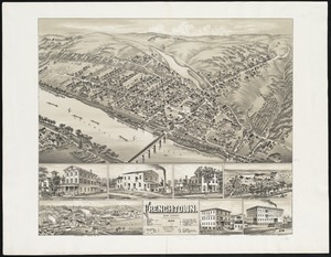
Frenchtown : New Jersey
2453.
Freti Magellanici ac novi freti vulgo le Maire
2454.
Freti Magellanici ac novi freti vulgo le Maire exactissima delineatio = Afbeelding der Straet Magellanes : so als de selve van...
2455.
From Monomoy and Nantucket Shoals to Muskeget Channel, Mass
2456.
From Monomoy and Nantucket Shoals to Muskeget Channel, Mass
2457.
From Muskeget Channel to Buzzard's Bay and entrance to Vineyard Sound, Mass
2458.
From Muskeget Channel to Buzzard's Bay and entrance to Vineyard Sound, Mass
2459.
From Vicksburg to New Orleans
2460.
A front view of the lines taken from the advanced post near Browns house : A view of the harbour of Boston taken from Fort Hill...
‹ Prev
Next ›
1
2
…
119
120
121
122
123
124
125
126
127
…
438
439


![[Frantia]](https://bpldcassets.blob.core.windows.net/derivatives/images/commonwealth:7h14b063x/image_thumbnail_300.jpg)