Toggle navigation
LMEC Home
Exhibitions
Georeferencing
Tools for Teachers
Collections
My Favorites
Sign Up / Log In
Search
Search the map portal
Map Collection
Map Collection
Map Sets
Search
Search
Search for
Search In
All Fields
Creator
Title
Subject
Place
Search All Digital Collections
Advanced Search
8251 Results
My Search
Start Over
More Like
commonwealth:6h446w75p
Remove constraint More Like: commonwealth:6h446w75p
Filter your Search
Place
North and Central America
5,000
United States
3,690
Suffolk (county)
1,114
Boston
1,087
Europe
963
Canada
427
France
269
Massachusetts
256
more
Place
»
Topic
Boston (Mass.)--Maps
594
United States--Maps
270
Real property--Massachusetts--Boston--Maps
252
Landowners--Massachusetts--Boston--Maps
169
Massachusetts--Maps
160
City planning--Massachusetts--Boston--Maps
112
North America--Maps--Early works to 1800
103
New England--Maps
99
more
Topic
»
Date
Date range begin
–
Date range end
Current results range from
1482
to
2023
View distribution
Creator
United States. Hydrographic Office
357
O.H. Bailey & Co
148
Des Barres, Joseph F. W. (Joseph Frederick Wallet), 1722-1824
123
United States. Post Office Dept
120
Boston Redevelopment Authority
116
Ptolemy, 2nd cent
100
Walling, Henry Francis, 1825-1888
94
Bromley, George Washington
85
more
Creator
»
Format
Maps/Atlases
8,192
Manuscripts
215
Prints
51
Books
36
Objects/Artifacts
10
Drawings/Illustrations
8
Posters
4
Georeferenced
Yes
870
No
7,381
Collection
Norman B. Leventhal Map Center Collection
8,163
Boston and New England Maps
2,237
Urban Maps
1,978
Maritime Charts and Atlases
750
American Revolutionary War-Era Maps
616
Boston Redevelopment Authority Collection
139
Massachusetts Real Estate Atlases
35
Available to use
No known restrictions
8,075
Creative Commons license
46
Search Constraints
Sort by relevance
relevance
title
date (asc)
date (desc)
Number of results to display per page
20 per page
10
per page
20
per page
50
per page
100
per page
View results as:
grid view
map view
Search Results
61.
Atlas of the county of Suffolk, Massachusetts : vol. 6th including the late city of Charlestown, now wards 20,21 and 22, city...
62.
Boylston Street : Fenway to Massachusetts Avenue
63.
Campus High School urban renewal area Mass. r-129 : property map
64.
City atlas of Boston, Massachusetts : complete in one volume : from official records, private plans and actual surveys
65.
Copies of plans of various parts of Brookline and Roxbury
66.
East Boston flood risk
67.
Plan of 82 building lots, in the town of Brighton, comprising 48 acres of the Parkman Farm next the estate of Saml. Bigelow...
68.
Plan of an estate belonging to the City of Boston to be sold by public auction on Wednesday, Sept. 14th, 1881 ... : per order...
69.
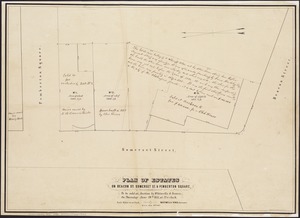
Plan of building lots on Phillips Place, Tremont & Somerset Streets
70.
Plan of building lots on Phillips Place, Tremont & Somerset Streets
71.
Plan of city lands and streets s.w. of Dover St : prepared from new surveys
72.
Plan of city lands to be sold Oct. 30th 1850
73.
Plan of City Wharf in Boston, Mass : shewing 14 lots of land on the side of the south dock of said wharf & Commercial St. : to...
74.
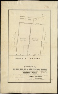
Plan of estate nos 207, 209, 211 & 215 Federal Street, belonging to the estate of the late Solomon Piper : to be sold at public...
75.
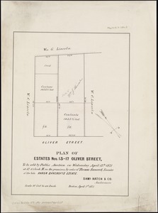
Plan of estates nos. 13-17 Oliver Street, to be sold by public auction on Wednesday April 12th 1871 at 12 o'clock m. on the...
76.
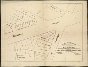
Plan of estates on Beacon St., Somerset St. & Pemberton Square : to be sold at auction by Whitwells & Seaver, on Thursday June...
77.
Plan of estates on Suffolk St. District : belonging to the City of Boston : to be sold at public auction, Dec. 23rd 1871
78.
Plan of house lots in Boston belonging to Otis H. Weed
79.
Plan of land and street layout in Boston, Mass., Hyde Park : prepared for the Stoney Brook Land Trust
80.
Plan of lands belonging to the Commonwealth of Massachusetts
‹ Prev
Next ›
1
2
3
4
5
6
7
8
…
412
413