Toggle navigation
LMEC Home
Exhibitions
Georeferencing
Tools for Teachers
Collections
My Favorites
Sign Up / Log In
Search
Search the map portal
Map Collection
Map Collection
Map Sets
Search
Search
Search for
Search In
All Fields
Creator
Title
Subject
Place
Search All Digital Collections
Advanced Search
8777 Results
My Search
Start Over
More Like
commonwealth:4m90fp16k
Remove constraint More Like: commonwealth:4m90fp16k
Filter your Search
Place
North and Central America
6,000
United States
4,917
Massachusetts
2,084
Europe
1,396
Suffolk (county)
1,048
Boston
1,021
Canada
471
Asia
438
more
Place
»
Topic
Boston (Mass.)--Maps
588
United States--Maps
330
Real property--Massachusetts--Boston--Maps
175
Massachusetts--Maps
165
Landowners--Massachusetts--Boston--Maps
133
New England--Maps
127
North America--Maps--Early works to 1800
103
Europe--Maps
79
more
Topic
»
Date
Date range begin
–
Date range end
Current results range from
1482
to
2023
View distribution
Creator
United States. Hydrographic Office
595
O.H. Bailey & Co
148
Des Barres, Joseph F. W. (Joseph Frederick Wallet), 1722-1824
123
United States. Post Office Dept
120
Ptolemy, 2nd cent
100
Walling, Henry Francis, 1825-1888
94
Geological Survey (U.S.)
87
Jefferys, Thomas, -1771
86
more
Creator
»
Format
Maps/Atlases
8,717
Manuscripts
215
Prints
56
Books
36
Objects/Artifacts
10
Drawings/Illustrations
8
Posters
5
Georeferenced
Yes
873
No
7,904
Collection
Norman B. Leventhal Map & Education Center Collection
8,704
Boston and New England Maps
2,239
Urban Maps
2,023
Maritime Charts and Atlases
1,083
American Revolutionary War-Era Maps
682
Boston Redevelopment Authority Collection
87
American Antiquarian Society Collection
34
William L. Clements Library Collection
19
more
Collection
»
Available to use
No known restrictions
8,560
Creative Commons license
53
Search Constraints
Sort by relevance
relevance
title
date (asc)
date (desc)
Number of results to display per page
20 per page
10
per page
20
per page
50
per page
100
per page
View results as:
grid view
map view
Search Results
1.
Map of Maine, New Hampshire, and Vermont : compiled from the latest authorities
2.
Map of Maine, New Hampshire and Vermont, from the most authentic sources
3.
Map of the country copied from Hale's map of N. E. with railroad route from Boston to Lake Champlain : through Keene, N. H
4.
Map of the rail road from Boston to Stanstead
5.
Ensign, Bridgman & Fanning's rail road map of the United States, showing the depots & stations
6.
Explorer's map & directory of the New England Coast : New London, Connecticut, to Passamaquoddy Bay, Canada : a comprehensive...
7.
Map of the northern part of New England : compiled for Pres't. Dwight's travels
8.
This plan of Kennebeck & Sagadahock Rivers & country adjacent
9.
Colton's New Hampshire
10.
Colton's New Hampshire
11.
Hammond's new road map of eastern Massachusetts and southern New Hampshire
12.
Manuscript maps of U.S. states
13.
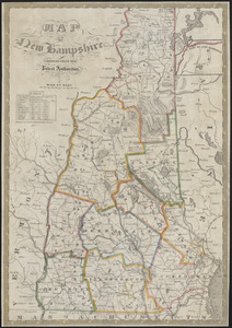
Map of New Hampshire : compiled from the latest authorities
14.
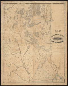
Map of the mountain and lake regions of New-Hampshire with rail-road routes
15.
Map showing the proposed line of the Manchester Rail Road as petitioned for by S.D. Bell & others
16.
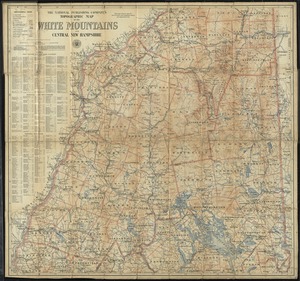
The National Publishing Company's topographic map of the White Mountains and central New Hampshire
17.
New Hampshire
18.
New Hampshire
19.
New-Hampshire : from late survey
20.
Post route map of the states of New Hampshire, Vermont showing post offices with the intermediate distances on mail routes in...
‹ Prev
Next ›
1
2
3
4
5
…
438
439