Toggle navigation
LMEC Home
Exhibitions
Georeferencing
Tools for Teachers
Collections
My Favorites
Sign Up / Log In
Search
Search the map portal
Map Collection
Map Collection
Map Sets
Search
Search
Search for
Search In
All Fields
Creator
Title
Subject
Place
Search All Digital Collections
Advanced Search
8657 Results
My Search
Start Over
More Like
commonwealth:4m90f859w
Remove constraint More Like: commonwealth:4m90f859w
Filter your Search
Place
North and Central America
5,896
United States
4,815
Massachusetts
2,068
Europe
1,392
Suffolk (county)
1,041
Boston
1,014
Canada
449
Asia
437
more
Place
»
Topic
Boston (Mass.)--Maps
582
United States--Maps
279
Real property--Massachusetts--Boston--Maps
175
Massachusetts--Maps
161
Landowners--Massachusetts--Boston--Maps
133
North America--Maps--Early works to 1800
103
New England--Maps
101
Europe--Maps
79
more
Topic
»
Date
Date range begin
–
Date range end
Current results range from
1482
to
2023
View distribution
Creator
United States. Hydrographic Office
595
O.H. Bailey & Co
148
Des Barres, Joseph F. W. (Joseph Frederick Wallet), 1722-1824
123
United States. Post Office Dept
120
Ptolemy, 2nd cent
100
Walling, Henry Francis, 1825-1888
94
Geological Survey (U.S.)
86
Jefferys, Thomas, -1771
85
more
Creator
»
Format
Maps/Atlases
8,597
Manuscripts
215
Prints
56
Books
36
Objects/Artifacts
10
Drawings/Illustrations
8
Posters
5
Georeferenced
Yes
869
No
7,788
Collection
Norman B. Leventhal Map & Education Center Collection
8,647
Boston and New England Maps
2,221
Urban Maps
1,992
Maritime Charts and Atlases
1,083
American Revolutionary War-Era Maps
625
Boston Redevelopment Authority Collection
87
William L. Clements Library Collection
9
MacLean Collection Map Library
1
Available to use
No known restrictions
8,505
Creative Commons license
47
Search Constraints
Sort by relevance
relevance
title
date (asc)
date (desc)
Number of results to display per page
20 per page
10
per page
20
per page
50
per page
100
per page
View results as:
grid view
map view
Search Results
1.
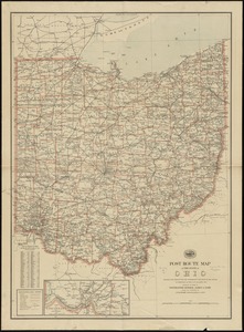
Post route map of the State of Ohio showing post offices with the intermediate distances and mail routes in operation on the...
2.
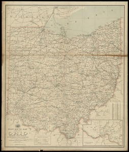
Post route map of the state of Ohio showing post offices with the intermediate distances on mail routes in operation on the...
3.
Post route map of the state of Ohio showing post offices with the intermediate distances on mail routes in operation on the 1st...
4.
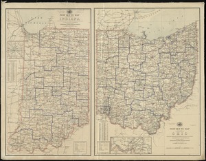
Post route map of the states of Ohio and Indiana with adjacent parts of Pennsylvania, Michigan, Illinois, Kentucky and West...
5.
Map exhibiting the country between Lakes Michigan and Erie, and the contested boundary lines
6.
Map, exhibiting the position of the several lines connected with the settlement of the Ohio boundary question
7.
Ohio boundary no. 1 South Bend of Lake Michigan : map, exhibiting the position occupied in the determination of the latitude of...
8.
Ohio boundary no. 1 South Bend of Lake Michigan : map, exhibiting the position occupied in the determination of the latitude of...
9.
Ohio boundary no. 2 : map exhibiting the positions occupied on the Maumee Bay and river: viz: Turtle Island, the North Cape,...
10.
Being a cartograph of Ohio : the oldest state west of the thirteen original colonies; now the fourth state in the Union in...
11.
Colton's map of the oil district of West Virginia and Ohio
12.
Geologic map of Ohio
13.
A geological map of Ohio
14.
A map of part of the N:W: Territory of the United States : compiled from actual surveys, and the best information
15.
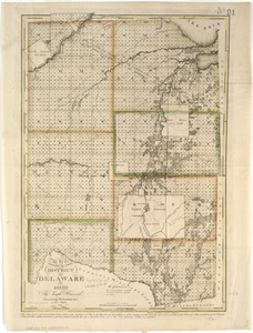
Map of the district of Delaware in Ohio
16.
Map of the state of Ohio
17.
Map of the states of Ohio, Indiana and Illinois with the settled parts of Michigan & Wisconsin
18.
Map of Virginia, West Virginia and Ohio : showing Norfolk and Western Railway : main line branches and connections
19.
Plat of the seven ranges of townships being part of the territory of the United States n.w. of the Ohio River which by a late...
20.
State of Ohio
‹ Prev
Next ›
1
2
3
4
5
…
432
433