Toggle navigation
LMEC Home
Exhibitions
Georeferencing
Tools for Teachers
Collections
My Favorites
Sign Up / Log In
Search
Search the map portal
Map Collection
Map Collection
Map Sets
Search
Search
Search for
Search In
All Fields
Creator
Title
Subject
Place
Search All Digital Collections
Advanced Search
8199 Results
My Search
Start Over
More Like
commonwealth:4m90f361w
Remove constraint More Like: commonwealth:4m90f361w
Filter your Search
Place
North and Central America
4,948
United States
3,780
Suffolk (county)
1,027
Boston
1,000
Europe
963
Canada
428
Massachusetts
294
France
269
more
Place
»
Topic
Boston (Mass.)--Maps
575
United States--Maps
270
Real property--Massachusetts--Boston--Maps
174
Massachusetts--Maps
160
Landowners--Massachusetts--Boston--Maps
132
North America--Maps--Early works to 1800
103
New England--Maps
99
Europe--Maps
78
more
Topic
»
Date
Date range begin
–
Date range end
Current results range from
1482
to
2023
View distribution
Creator
United States. Hydrographic Office
357
O.H. Bailey & Co
148
Des Barres, Joseph F. W. (Joseph Frederick Wallet), 1722-1824
123
United States. Post Office Dept
120
Ptolemy, 2nd cent
100
Walling, Henry Francis, 1825-1888
94
Jefferys, Thomas, -1771
84
Geological Survey (U.S.)
82
more
Creator
»
Format
Maps/Atlases
8,140
Manuscripts
217
Prints
51
Books
36
Objects/Artifacts
10
Drawings/Illustrations
8
Posters
4
Georeferenced
Yes
869
No
7,330
Collection
Norman B. Leventhal Map Center Collection
8,163
Boston and New England Maps
2,184
Urban Maps
1,926
Maritime Charts and Atlases
750
American Revolutionary War-Era Maps
650
Boston Redevelopment Authority Collection
86
William L. Clements Library Collection
27
American Antiquarian Society Collection
4
more
Collection
»
Available to use
No known restrictions
8,025
Creative Commons license
47
Search Constraints
Sort by relevance
relevance
title
date (asc)
date (desc)
Number of results to display per page
20 per page
10
per page
20
per page
50
per page
100
per page
View results as:
grid view
map view
Search Results
41.
New York city map
42.
Plan for the improvement of the Central Park, adopted by the Commissioners, June 3rd, 1856
43.
Plan of the city of New York : showing the made and swamp land
44.
Rand McNally & Co.'s map of New York City, Brooklyn, Jersey City and vicinity
45.
The strangers mercantile guide map of the cities of New York, Brooklyn, Jersey City, Hoboken, etc
46.
British troop dispositions in and near New York City, Sept. 2d 1781
47.
Ye commencement for draft of New York Island
48.
The Delancey lands on Manhattan Island
49.
Disposition of the British forces on Long Island, Staten Island, and Manhattan Island, under Cornwallis and Knyphausen
50.
Insurance maps of the city of New York
51.
Isle de Newyork : reconnaissance des ouvrages du nord de lisle de Newyork faite en presence des Généraux, Wasington et...
52.
Kings Bridge
53.
Land holdings on Kip's Bay, Manhattan Island
54.
Map of New York I. with the adjacent rocks and other remarkable parts of Hell-Gate
55.
A map of the country adjacent to Kingsbridge, surveyed by order of his excellency General Sir Henry Clinton K.B., commander in...
56.
Part of the modern counties of Westchester and Bronx
57.
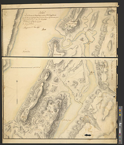
Plan des environs de Kingsbridge jusqu'au Fort Knyphausen avec les ouvrages de fortification faites dans l'année 1779 & de ceux...
58.
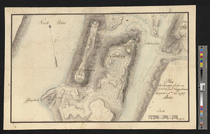
Plan des ouvrages faites en front du fort Knyphausen, New Yorck ce 4 me. Novr 1779
59.
A plan of the City of New York from an actual survey anno domini MDCCLV
60.
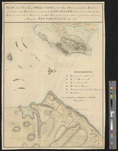
Plan of the narrows of Hell Gate, on the East River near which batteries of cannon, and morters, were erected on Long Island :...
‹ Prev
Next ›
1
2
3
4
5
6
7
…
409
410