Toggle navigation
LMEC Home
Exhibitions
Georeferencing
Tools for Teachers
Collections
My Favorites
Sign Up / Log In
Search
Search the map portal
Map Collection
Map Collection
Map Sets
Search
Search
Search for
Search In
All Fields
Creator
Title
Subject
Place
Search All Digital Collections
Advanced Search
9088 Results
My Search
Start Over
More Like
commonwealth:4j03gh12z
Remove constraint More Like: commonwealth:4j03gh12z
Filter your Search
Place
North and Central America
6,319
United States
5,237
Massachusetts
2,156
Suffolk (county)
1,439
Boston
1,412
Europe
1,396
Canada
449
Asia
438
more
Place
»
Topic
Boston (Mass.)--Maps
687
City planning--Massachusetts--Boston--Maps
418
United States--Maps
282
Urban renewal--Massachusetts--Boston--Maps
252
Real property--Massachusetts--Boston--Maps
251
Landowners--Massachusetts--Boston--Maps
169
Massachusetts--Maps
162
Buildings--Massachusetts--Boston--Maps
125
more
Topic
»
Date
Date range begin
–
Date range end
Current results range from
1482
to
2023
View distribution
Creator
United States. Hydrographic Office
595
Boston Redevelopment Authority
391
O.H. Bailey & Co
148
Des Barres, Joseph F. W. (Joseph Frederick Wallet), 1722-1824
123
United States. Post Office Dept
120
Ptolemy, 2nd cent
100
Walling, Henry Francis, 1825-1888
94
Geological Survey (U.S.)
86
more
Creator
»
Format
Maps/Atlases
9,028
Manuscripts
215
Prints
56
Books
36
Objects/Artifacts
10
Drawings/Illustrations
8
Posters
5
Georeferenced
Yes
870
No
8,218
Collection
Norman B. Leventhal Map & Education Center Collection
8,697
Boston and New England Maps
2,589
Urban Maps
2,376
Maritime Charts and Atlases
1,083
American Revolutionary War-Era Maps
620
Boston Redevelopment Authority Collection
440
Massachusetts Real Estate Atlases
34
William L. Clements Library Collection
3
more
Collection
»
Available to use
No known restrictions
8,907
Creative Commons license
49
Search Constraints
Sort by relevance
relevance
title
date (asc)
date (desc)
Number of results to display per page
20 per page
10
per page
20
per page
50
per page
100
per page
View results as:
grid view
map view
Search Results
101.
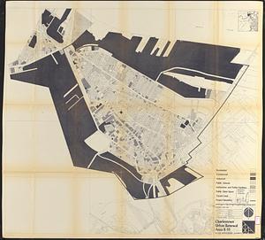
Charlestown urban renewal area r-55 : proposed land use
102.
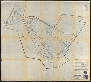
Charlestown urban renewal area r-55 : existing land use
103.
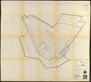
Charlestown urban renewal area r-55 : right of way adjustments
104.
Charlestown urban renewal area r-55 : existing land use
105.
Charlestown urban renewal area r-55 : existing zoning
106.
Charlestown urban renewal area r-55 : proposed zoning
107.
Disposition parcels, Charlestown urban renewal area, Massachusetts R-55
108.
Boston University buildings
109.
City of Boston : topographic and planimetric survey
110.
Map of New York and vicinity
111.
Map of the city of Boston, Massts., 1852
112.
Outline map and view of the Prudential Center area
113.
Shadow analysis
114.
Washington Street corridor : South Cove to Forest Hills
115.
Building #33, Charlestown Navy Yard flr. plans
116.
Atlas of the city of Boston : Charlestown : from actual surveys and official plans
117.
Atlas of the city of Boston : Charlestown and Brighton, volume six : from actual surveys and official records
118.
Atlas of the city of Boston : Charlestown and East Boston : from actual surveys and official plans
119.
Atlas of the city of Boston : Charlestown and East Boston : from actual surveys and official plans
120.
Atlas of the city of Boston : Charlestown, Mass. : volume ten : from actual surveys and official plans
‹ Prev
Next ›
1
2
3
4
5
6
7
8
9
10
…
454
455