Toggle navigation
LMEC Home
Exhibitions
Georeferencing
Tools for Teachers
Collections
My Favorites
Sign Up / Log In
Search
Search the map portal
Map Collection
Map Collection
Map Sets
Search
Search
Search for
Search In
All Fields
Creator
Title
Subject
Place
Search All Digital Collections
Advanced Search
8943 Results
My Search
Start Over
More Like
commonwealth:3f463917s
Remove constraint More Like: commonwealth:3f463917s
Filter your Search
Place
North and Central America
6,174
United States
5,078
Massachusetts
2,206
Europe
1,396
Suffolk (county)
1,207
Boston
1,180
Canada
450
Asia
438
more
Place
»
Topic
Boston (Mass.)--Maps
752
United States--Maps
282
Massachusetts--Maps
235
Real property--Massachusetts--Boston--Maps
195
City planning--Massachusetts--Boston--Maps
157
Landowners--Massachusetts--Boston--Maps
142
New England--Maps
106
North America--Maps--Early works to 1800
103
more
Topic
»
Date
Date range begin
–
Date range end
Current results range from
1482
to
2023
View distribution
Creator
United States. Hydrographic Office
595
Boston Redevelopment Authority
162
O.H. Bailey & Co
148
Des Barres, Joseph F. W. (Joseph Frederick Wallet), 1722-1824
124
United States. Post Office Dept
120
Ptolemy, 2nd cent
100
Walling, Henry Francis, 1825-1888
95
Geological Survey (U.S.)
92
more
Creator
»
Format
Maps/Atlases
8,882
Manuscripts
219
Prints
56
Books
36
Objects/Artifacts
10
Drawings/Illustrations
8
Posters
5
Ephemera
1
Georeferenced
Yes
894
No
8,049
Collection
Norman B. Leventhal Map & Education Center Collection
8,765
Boston and New England Maps
2,404
Urban Maps
2,144
Maritime Charts and Atlases
1,083
American Revolutionary War-Era Maps
659
Boston Redevelopment Authority Collection
194
Applied Geographics, Inc. Records
22
Mapping Boston Collection
22
more
Collection
»
Available to use
No known restrictions
8,707
Creative Commons license
73
Search Constraints
Sort by relevance
relevance
title
date (asc)
date (desc)
Number of results to display per page
20 per page
10
per page
20
per page
50
per page
100
per page
View results as:
grid view
map view
Search Results
5161.
Map showing the number of chartered banks in New Brunswick, Nova Scotia, and Prince Edward Island
5162.
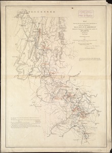
Map showing the operations of the national forces under the command of Maj. Gen. W.T. Sherman during the campaign resulting in...
5163.
Map showing the overland and overseas flights of Charles A. Lindbergh
5164.
Map showing the proposed line of the Manchester Rail Road as petitioned for by S.D. Bell & others
5165.
Map showing the proposed rail roads from Boston to Burlington, from Hale's map of New England
5166.
Map showing the relative distances of Porsmouth [i.e. Portsmouth] and Boston from Concord & Manchester, N.H
5167.
Map showing the routes of The Winthrop Steamboat Co
5168.
Map showing the seat of war in middle and east Tennessee
5169.
Map showing the telegraph lines in operation, under contract, and contemplated, to complete the circuit of the globe
5170.
Map showing the telegraph lines in operation, under contract, and contemplated, to complete the circuit of the globe
5171.
Map showing the temporary connection of Sudbury River with Lake Cochituate
5172.
Map showing transmission lines of the Shawinigan Water & Power Co.
5173.
Map sixth division railway mail service
5174.
Map tenth division railway mail service
5175.
Map third division railway mail service
5176.
Map to accompany the report on the exploratory survey of the Canadian Pacific Railway
5177.
Map to illustrate an exploration of the country lying between the Missouri River and the Rocky Mountains, on the line of the...
5178.
Map to illustrate the battle of Bull Run, Stone Bridge or Manassas Plains
5179.
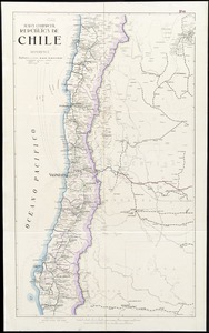
Mapa comercial de la República de Chile
5180.
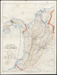
Mapa comercial de la República de Colombia
‹ Prev
Next ›
1
2
…
255
256
257
258
259
260
261
262
263
…
447
448


![Map showing the relative distances of Porsmouth [i.e. Portsmouth] and Boston from Concord & Manchester, N.H](https://bpldcassets.blob.core.windows.net/derivatives/images/commonwealth:7h14b104z/image_thumbnail_300.jpg)