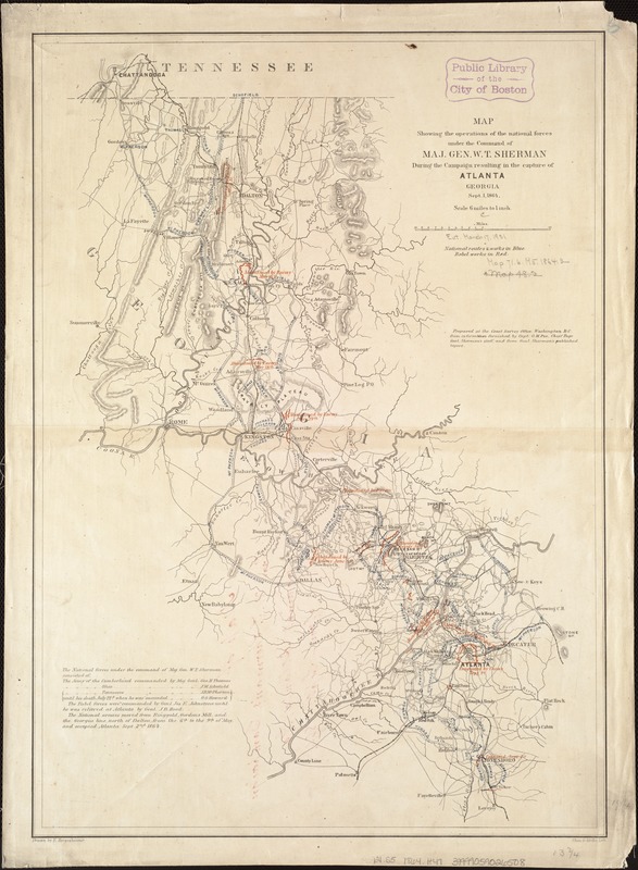
Map showing the operations of the national forces under the command of Maj. Gen. W.T. Sherman during the campaign resulting in the capture of Atlanta, Georgia, Sept. 1, 1864
Item Information
- Title:
- Map showing the operations of the national forces under the command of Maj. Gen. W.T. Sherman during the campaign resulting in the capture of Atlanta, Georgia, Sept. 1, 1864
- Creator:
- Hergesheimer, E. (Edwin)
- Name on Item:
-
drawn by E. Hergesheimer ; Chas. G. Krebs, lith.
- Date:
-
[1864]
- Format:
-
Maps/Atlases
- Location:
-
Boston Public Library
Norman B. Leventhal Map & Education Center - Collection (local):
-
Norman B. Leventhal Map & Education Center Collection
- Subjects:
-
Atlanta Campaign, 1864--Maps
Georgia--History--Civil War, 1861-1865--Campaigns--Maps
- Places:
-
Georgia
- Extent:
- 1 map : col. ; 50 x 35 cm.
- Terms of Use:
-
No known copyright restrictions.
No known restrictions on use.
- Publisher:
-
Washington, D.C :
Coast Survey Office
- Scale:
-
Scale 1:380,160. 6 miles to 1 in.
- Language:
-
English
- Notes:
-
Relief shown by hachures.
Shows the area between Chattanooga, Tenn. and Lovejoy, Ga.
"Prepared at the Coast Survey Office, Washington, D.C., from information furnished by Capt. O. M. Poe, Chief Engr. Genl. Sherman's staff and from Gen. Sherman's published report."
- Notes (date):
-
This date is inferred.
- Identifier:
-
06_01_006553
- Call #:
-
G3921.S5 1864 .H47
- Barcode:
-
39999059026508
- LCCN:
-
80691164


![Map[s] illustrating the military operations of the Atlanta campaign ... 1864](https://bpldcassets.blob.core.windows.net/derivatives/images/commonwealth:3f463432v/image_thumbnail_300.jpg)
