Toggle navigation
LMEC Home
Exhibitions
Georeferencing
Tools for Teachers
Collections
My Favorites
Sign Up / Log In
Search
Search the map portal
Map Collection
Map Collection
Map Sets
Search
Search
Search for
Search In
All Fields
Creator
Title
Subject
Place
Search All Digital Collections
Advanced Search
8168 Results
My Search
Start Over
More Like
commonwealth:3f463891v
Remove constraint More Like: commonwealth:3f463891v
Filter your Search
Place
North and Central America
4,918
United States
3,602
Suffolk (county)
1,026
Boston
999
Europe
963
Canada
427
France
269
Massachusetts
249
more
Place
»
Topic
Boston (Mass.)--Maps
574
United States--Maps
270
Real property--Massachusetts--Boston--Maps
174
Massachusetts--Maps
160
Landowners--Massachusetts--Boston--Maps
132
North America--Maps--Early works to 1800
103
New England--Maps
99
Europe--Maps
78
more
Topic
»
Date
Date range begin
–
Date range end
Current results range from
1482
to
2023
View distribution
Creator
United States. Hydrographic Office
361
O.H. Bailey & Co
148
Des Barres, Joseph F. W. (Joseph Frederick Wallet), 1722-1824
123
United States. Post Office Dept
120
Ptolemy, 2nd cent
100
Walling, Henry Francis, 1825-1888
94
Jefferys, Thomas, -1771
84
Geological Survey (U.S.)
82
more
Creator
»
Format
Maps/Atlases
8,109
Manuscripts
215
Prints
51
Books
36
Objects/Artifacts
10
Drawings/Illustrations
8
Posters
4
Georeferenced
Yes
868
No
7,300
Collection
Norman B. Leventhal Map Center Collection
8,166
Boston and New England Maps
2,184
Urban Maps
1,925
Maritime Charts and Atlases
754
American Revolutionary War-Era Maps
618
Boston Redevelopment Authority Collection
86
William L. Clements Library Collection
2
Available to use
No known restrictions
8,025
Creative Commons license
46
Search Constraints
Sort by relevance
relevance
title
date (asc)
date (desc)
Number of results to display per page
10 per page
10
per page
20
per page
50
per page
100
per page
View results as:
grid view
map view
Search Results
1.
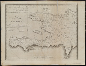
Carte de la partie Françoise de St. Domingue = A map of the French part of St. Domingo
2.
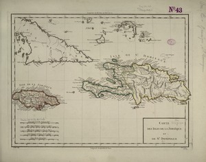
Carte des isles de la Jamaïque et de St. Domingue
3.
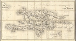
Mapa de la isla de Santo Domingo
4.
Tactical pilotage chart, TPC
5.
West Indies, Haiti or Santo Domingo, Cayes, Flamand, St. Louis and Meste Bays : from French government surveys to 1872, with...
6.
West Indies, ports on the north and west coasts of Haiti : from the most recent surveys
7.
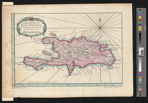
Carte de l'Isle de Saint Domingue : pour servir a l'Histoire générale des voyages
8.
Plan du superbe quartier neuf appellé le Bays de Coustard ou sont representées les nouvelles distributions de terre faitts en...
9.
West Indies, eastern part of Bahama Islands with part of Cuba and north coast of Santo Domingo : compiled from the latest...
10.
West Indies, eastern part of Bahama Islands with part of Cuba and north coast of Santo Domingo : compiled from the latest...
‹ Prev
Next ›
1
2
3
4
5
…
816
817