Toggle navigation
LMEC Home
Exhibitions
Georeferencing
Tools for Teachers
Collections
My Favorites
Sign Up / Log In
Search
Search the map portal
Map Collection
Map Collection
Map Sets
Search
Search
Search for
Search In
All Fields
Creator
Title
Subject
Place
Search All Digital Collections
Advanced Search
504 Results
My Search
Start Over
More Like
commonwealth:2n49wm032
Remove constraint More Like: commonwealth:2n49wm032
Filter your Search
Place
North and Central America
501
United States
498
Suffolk (county)
490
Boston
489
Massachusetts
191
South End
49
Roxbury
47
Downtown Boston
40
more
Place
»
Topic
City planning--Massachusetts--Boston--Maps
418
Urban renewal--Massachusetts--Boston--Maps
253
Boston (Mass.)--Maps
154
Land use--Massachusetts--Boston--Maps
102
Buildings--Massachusetts--Boston--Maps
81
Real property--Massachusetts--Boston--Maps
49
Roxbury (Boston, Mass.)--Maps
43
South End (Boston, Mass.)--Maps
42
more
Topic
»
Date
Date range begin
–
Date range end
Current results range from
1835
to
2020
View distribution
Creator
Boston Redevelopment Authority
370
Massachusetts Bay Transportation Authority
12
Downtown Waterfront Corporation
10
Victor Gruen Associates
10
Boston (Mass.). Parks and Recreation Department
9
Boston Elevated Railway Company
8
General Drafting Company
8
Sasaki Associates
6
more
Creator
»
Format
Maps/Atlases
503
Drawings/Illustrations
3
Manuscripts
1
Prints
1
Georeferenced
Yes
5
No
499
Collection
Boston and New England Maps
470
Urban Maps
452
Boston Redevelopment Authority Collection
439
Norman B. Leventhal Map & Education Center Collection
118
Applied Geographics, Inc. Records
1
David Judkins Weaver Papers
1
Available to use
No known restrictions
502
Creative Commons license
1
Search Constraints
Sort by relevance
relevance
title
date (asc)
date (desc)
Number of results to display per page
20 per page
10
per page
20
per page
50
per page
100
per page
View results as:
grid view
map view
Search Results
381.
Report on improvements to the Boston main drainage system
382.
Report on the alternate master highway plan for the Boston metropolitan area
383.
Ruggles Center : existing condition plan
384.
Ruggles Center : site area diagram
385.
Shawmut Avenue
386.
South Boston urban renewal area R-51
387.
South Cove property ownership 1950
388.
South Cove property ownership 1962
389.
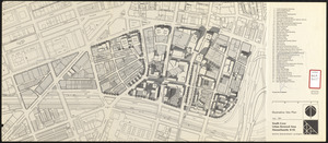
South Cove urban renewal area Massachusetts R-92 : illustrative site plan
390.
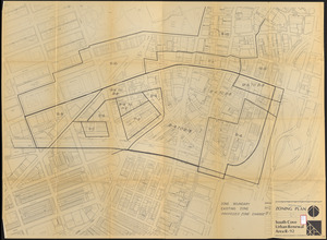
South Cove urban renewal area R-92 : zoning plan
391.
South End renewal area : locality map
392.
South End renewal area : existing conditions & proposed treatment areas
393.
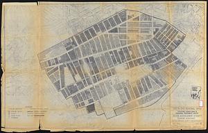
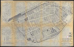
South End renewal area : existing land use
394.
South End urban renewal area R-56 : property map
395.
South End urban renewal area R-56 : property map
396.
South End urban renewal area R-56 : property map
397.
South End urban renewal area R-56 : proposed rights-of-way
398.
South End urban renewal area R-56 : re-use parcels
399.
South End urban renewal area R-56 : re-use parcels
400.
South End urban renewal area R-56 : zone district changes
‹ Prev
Next ›
1
2
…
16
17
18
19
20
21
22
23
24
25
26