Toggle navigation
LMEC Home
Exhibitions
Georeferencing
Tools for Teachers
Collections
My Favorites
Sign Up / Log In
Search
Search the map portal
Map Collection
Map Collection
Map Sets
Search
Search
Search for
Search In
All Fields
Creator
Title
Subject
Place
Search All Digital Collections
Advanced Search
8931 Results
My Search
Start Over
More Like
commonwealth:1257c311p
Remove constraint More Like: commonwealth:1257c311p
Filter your Search
Place
North and Central America
6,162
United States
5,078
Massachusetts
2,143
Europe
1,396
Suffolk (county)
1,277
Boston
1,250
Canada
449
Asia
438
more
Place
»
Topic
Boston (Mass.)--Maps
753
United States--Maps
282
Real property--Massachusetts--Boston--Maps
254
City planning--Massachusetts--Boston--Maps
196
Landowners--Massachusetts--Boston--Maps
170
Massachusetts--Maps
166
New England--Maps
104
North America--Maps--Early works to 1800
103
more
Topic
»
Date
Date range begin
–
Date range end
Current results range from
1482
to
2023
View distribution
Creator
United States. Hydrographic Office
595
Boston Redevelopment Authority
202
O.H. Bailey & Co
148
Des Barres, Joseph F. W. (Joseph Frederick Wallet), 1722-1824
124
United States. Post Office Dept
120
Ptolemy, 2nd cent
100
Walling, Henry Francis, 1825-1888
94
Geological Survey (U.S.)
87
more
Creator
»
Format
Maps/Atlases
8,871
Manuscripts
215
Prints
56
Books
36
Objects/Artifacts
10
Drawings/Illustrations
8
Posters
5
Georeferenced
Yes
885
No
8,046
Collection
Norman B. Leventhal Map & Education Center Collection
8,725
Boston and New England Maps
2,401
Urban Maps
2,185
Maritime Charts and Atlases
1,083
American Revolutionary War-Era Maps
638
Boston Redevelopment Authority Collection
233
Massachusetts Real Estate Atlases
38
Mapping Boston Collection
20
more
Collection
»
Available to use
No known restrictions
8,708
Creative Commons license
70
Search Constraints
Sort by relevance
relevance
title
date (asc)
date (desc)
Number of results to display per page
20 per page
10
per page
20
per page
50
per page
100
per page
View results as:
grid view
map view
Search Results
1601.
Block diagram showing terrain of the Balkan Peninsula
1602.
Block diagram showing terrain of the Trentino region
1603.
Block diagram showing terrain of the Trieste-Isonzo region
1604.
Block Island, Rhode Island
1605.
A block of 6 brick houses the property of Isaac Stebbins Esquire
1606.
Bloomingville, [Ohio]
1607.
Bloys
1608.
Blue Hills Reservation
1609.
Blue Hills Reservation
1610.
Bocche del Fiume Negro et Isole di Cape Verde : possedute dà Portoghesi, scoperte da Antonio di Nola Genouese nell' anno 1440,...
1611.
The Boone-Lincoln community where Daniel Boone was born, Berks County, Pennsylvania
1612.
Boothbay Harbor, Lincoln County, Maine : 1885
1613.
Bosnien und Dalmatien : vorzüglich nach österreichischen aufnahmen, mit benutzung von a Boués reisen (Montenegro nach...
1614.
The Bosphorus : from French and British surveys in 1853, corrected to 1872
1615.
Boston : 1899
1616.
Boston
1617.
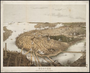
Boston : bird's-eye view from the north
1618.
Boston
1619.
Boston & Gloucester Steamboat Co. : summer season 1889
1620.
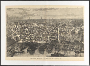
Boston after the great fire
‹ Prev
Next ›
1
2
…
77
78
79
80
81
82
83
84
85
…
446
447


![Bloomingville, [Ohio]](https://bpldcassets.blob.core.windows.net/derivatives/images/commonwealth:1v53jx86m/image_thumbnail_300.jpg)