Toggle navigation
LMEC Home
Exhibitions
Georeferencing
Tools for Teachers
Collections
My Favorites
Sign Up / Log In
Search
Search the map portal
Map Collection
Map Collection
Map Sets
Search
Search
Search for
Search In
All Fields
Creator
Title
Subject
Place
Search All Digital Collections
Advanced Search
112 Results
My Search
Start Over
More Like
commonwealth-oai:cn69r3484
Remove constraint More Like: commonwealth-oai:cn69r3484
Place
Quebec
Remove constraint Place: Quebec
Filter your Search
Place
Canada
112
North and Central America
112
Quebec
[remove]
112
Saint Lawrence River
40
Québec
23
United States
18
Sept Iles
13
Chaudière, Rivière
12
more
Place
»
Topic
United States--History--French and Indian War, 1754-1763--Maps
70
Saint Lawrence River--Maps
40
Québec (Québec)--Maps
21
Sept-Iles (Québec)--Maps
13
Chaudière River (Québec)--Maps
12
Longue-Pointe (Québec)--Maps
12
Mingan Islands (Québec)--Maps
12
Saguenay River (Québec)--Maps
12
more
Topic
»
Date
Date range begin
–
Date range end
Current results range from
1744
to
1900
1744 : 1901
1744
1901
View distribution
Creator
Jefferys, Thomas, -1771
13
Cook, James, 1728-1779
12
Desjardins, pilot of Québec
12
Holland, Samuel, 1728-1801
12
Robert Sayer and John Bennett (Firm)
12
Saunders, Charles, Sir, 1713?-1775
12
Montrésor, John, 1736-1799
8
Haldimand, Frederick, Sir, 1718-1791
5
more
Creator
»
Format
Maps/Atlases
111
Documents
1
Georeferenced
No
112
Collection
American Revolutionary War-Era Maps
111
William L. Clements Library Collection
111
Norman B. Leventhal Map & Education Center Collection
1
Available to use
No known restrictions
1
Search Constraints
Sort by relevance
relevance
title
date (asc)
date (desc)
Number of results to display per page
20 per page
10
per page
20
per page
50
per page
100
per page
View results as:
grid view
map view
Search Results
1.
The Cedres
2.
Continuation of the Grande Riviere with the village of Fariole lying near Cape Torment on the north shore
3.
Continuation of the River Chaudière &c.
4.
Continuation of the River Chaudière from where it falls into the St. Lawrence, as laid down in the lower plan, to the village...
5.
Continuation of the River Chaudière joining to A
6.
Continuation of the River Chaudière joining to B
7.
A correct plan of the environs of Quebec, and of the battle fought on the 13th September, 1759 : together with a particular...
8.
A draught of a route from Québec to Fort Halifax on the River Kennebec and back again to Québec by the rivers Chaudière and...
9.
French draught of Lake Champlain & Lake George with remarks of an English prisoner who return'd from Quebec to Fort Edward by...
10.
Lake Megantic and the Chaudière River : Québec July 25th, 1761
11.
Moosehead Lake and the immediate area to the west : Québec July 25th, 1761
12.
A new and accurate map of the English empire in North America : representing their rightful claim as confirm'd by charters, and...
13.
Parish of Batiscant. Parish of St. Pierre Becquet. Parish of Champlain. Parish of Gentilly
14.
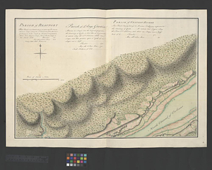
Parish of Beauport. Parish of L'Ange Gardien. Parish of Chateau Richer
15.
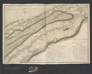
Parish of Berthier. Parish of St. François. Parish of St. Thomas
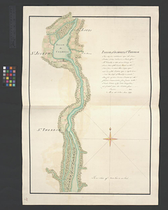
16.
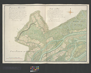
Parish of Bertier. Isle du Pas
17.
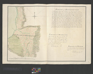
Parish of Boucherville. Parish de la Magdelaine. Parish of La Prairie
18.
Parish of Chambly & Ste. Therese
19.
Parish of Charlebourgh
20.
Parish of Chateau Gay
+
-
Redo search here
Search when I move the map
Leaflet
| ©
OpenStreetMap
contributors, ©
CartoDB
‹ Prev
Next ›
1
2
3
4
5
6