Toggle navigation
LMEC Home
Exhibitions
Georeferencing
Tools for Teachers
Collections
My Favorites
Sign Up / Log In
Search
Search the map portal
Map Collection
Map Collection
Map Sets
Search
Search
Search for
Search In
All Fields
Creator
Title
Subject
Place
Search All Digital Collections
Advanced Search
48 Results
My Search
Start Over
More Like
commonwealth-oai:sx61jk12g
Remove constraint More Like: commonwealth-oai:sx61jk12g
Place
Nova Scotia
Remove constraint Place: Nova Scotia
Filter your Search
Place
Canada
48
North and Central America
48
Nova Scotia
[remove]
48
Louisbourg
20
Halifax
14
Cape Breton Island
4
Annapolis Royal
3
Province of New Brunswick
3
more
Place
»
Topic
Louisbourg (N.S.)--Maps
20
Halifax (N.S.)--Maps
13
United States--History--French and Indian War, 1754-1763--Maps
13
United States--History--Revolution, 1775-1783--Maps
10
Nova Scotia--Maps
6
Louisbourg (N.S.)--History--Siege, 1758--Maps
5
Cape Breton Island (N.S.)--Maps
4
Annapolis Royal (N.S.)--Maps
3
more
Topic
»
Date
Date range begin
–
Date range end
Current results range from
1740
to
1783
1740 : 1784
1740
1784
View distribution
Creator
Sproule, Geo. F. (George F.), 1741-1817
4
Spry, William
4
Barron, Edward
3
Bastide, John Henry, approximately 1700-1770
3
Bellin, Jacques Nicolas, 1703-1772
3
Holland, Samuel, 1728-1801
3
Montrésor, John, 1736-1799
3
Langenschwarz, Frederich
2
more
Creator
»
Format
Maps/Atlases
48
Georeferenced
No
48
Collection
American Revolutionary War-Era Maps
48
William L. Clements Library Collection
48
Search Constraints
Sort by relevance
relevance
title
date (asc)
date (desc)
Number of results to display per page
20 per page
10
per page
20
per page
50
per page
100
per page
View results as:
grid view
map view
Search Results
1.
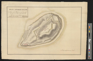
George's Island in Halifax harbor, Nova Scotia
2.
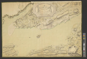
Halifax
3.
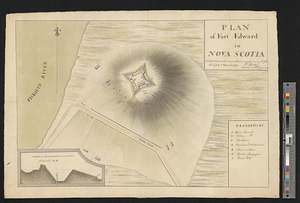
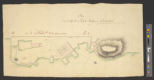
Plan of Fort Edward in Nova Scotia
4.
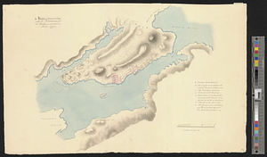
Plan of Georges Island : NB where the platforms are expres'd the guns are mounted but the merlons are not repaired
5.
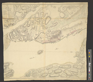
Plan of the environs of Halifax in Nova Scotia with the temporary works constructed for the protection of the town, and His...
6.
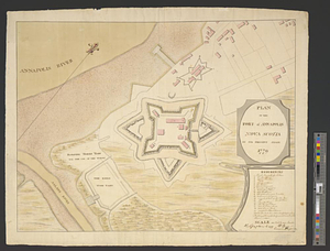
Plan of the fort of Annapolis Nova Scotia in its present state 1779
7.
Plan von dem schiff-bauplatz bei Hallifax in Neuscholland
8.
Plan von Halifax in Nord-America
9.
A sketch of Hallifax with its environs and the works, as executed in June 1776
10.
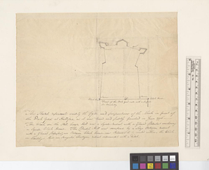
This sketch represents nearly the figure and proportions of the work in front of the dock yard at Hallifax as it was traced and...
11.
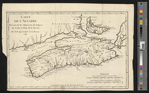
Carte de l'Accadie : dressée sur les manuscrits de Dépot des Cartes et Plans de la Marine
12.
A chart of the peninsula of Nova Scotia
13.
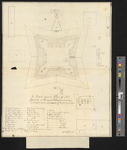
An exact ground plan of Fort Edward at Pesaquid taken from a survey and laid down by a scale of 60 feet to one inch
14.
An exact map of Nova Scotia, Newfoundland, gulf and river St. Laurence, and coast of Labrador from the latest observations 1777
15.
Gabarus Bay
16.
Grund riss de Americanischen insuln Cape Breton, St. Iean und Anticosti im Flusse S. Laurencii
17.
The harbour of Halifax
18.
Louisbourg, latitude 45⁰ 50' north
19.
Map of the British landings at Louisbourg
20.
Map of the coast of Cape Breton from Fort William to Louisbourg
‹ Prev
Next ›
1
2
3