Toggle navigation
LMEC Home
Exhibitions
Georeferencing
Tools for Teachers
Collections
My Favorites
Sign Up / Log In
Search
Search the map portal
Map Collection
Map Collection
Map Sets
Search
Search
Search for
Search In
All Fields
Creator
Title
Subject
Place
Search All Digital Collections
Advanced Search
149 Results
My Search
Start Over
More Like
commonwealth-oai:d791xf48g
Remove constraint More Like: commonwealth-oai:d791xf48g
Topic
United States--History--French and Indian War, 1754-1763--Maps
Remove constraint Topic: United States--History--French and Indian War, 1754-1763--Maps
Filter your Search
Place
North and Central America
149
Canada
88
United States
74
Quebec
69
New York
46
Saint Lawrence River
24
Pennsylvania
14
Nova Scotia
13
more
Place
»
Topic
United States--History--French and Indian War, 1754-1763--Maps
[remove]
149
Saint Lawrence River--Maps
24
Louisbourg (N.S.)--Maps
11
Québec (Québec)--Maps
11
Québec Campaign, Québec, 1759--Maps
11
Chaudière River (Québec)--Maps
10
George, Lake (N.Y. : Lake)--Maps
9
Richelieu River (N.Y. and Vt-Québec)--Maps
8
more
Topic
»
Date
Date range begin
–
Date range end
Current results range from
1752
to
1792
1752 : 1793
1752
1793
View distribution
Creator
Rocque, Mary Ann
24
Jefferys, Thomas, -1771
9
Montrésor, John, 1736-1799
6
Orme, Robert, -1781
6
Shaw, Alexander, Lieutenant
6
Haldimand, Frederick, Sir, 1718-1791
4
Coentgen, Heinrich Hugo
3
Rivez, Charles
3
more
Creator
»
Format
Maps/Atlases
148
Prints
1
Georeferenced
No
149
Collection
American Revolutionary War-Era Maps
149
William L. Clements Library Collection
149
Search Constraints
Sort by relevance
relevance
title
date (asc)
date (desc)
Number of results to display per page
20 per page
10
per page
20
per page
50
per page
100
per page
View results as:
grid view
map view
Search Results
1.
An accurate map of Canada, with the adjacent countries; exhibiting the late seat of war between the English & French in those...
2.
Attaques des forts de Chouaguen en Amérique pris par les français commandés par le Marquis de Montcalm le 14 Août 1756
3.
Attaques des retranchemens devant le fort Carillon en Amérique par les anglais commandés par le général Abercrombie contre les...
4.
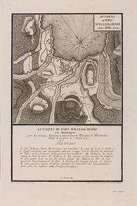
Attaques du fort William-Henri en Amérique par les troupes français aux ordres du Marquis de Montcalm prise de ce fort le 7...
5.
British attack upon Ticonderoga, July 7 & 8, 1758
6.
The Cedres
7.
Continuation of the Grande Riviere with the village of Fariole lying near Cape Torment on the north shore
8.
Continuation of the River Chaudière &c.
9.
Continuation of the River Chaudière from where it falls into the St. Lawrence, as laid down in the lower plan, to the village...
10.
Continuation of the River Chaudière joining to A
11.
Continuation of the River Chaudière joining to B
12.
A correct plan of the environs of Quebec, and of the battle fought on the 13th September, 1759 : together with a particular...
13.
A draught of a route from Québec to Fort Halifax on the River Kennebec and back again to Québec by the rivers Chaudière and...
14.
Draught of the River Pittquioyack in the Bay of Fundy 1758
15.
Draught of the river St. Lawrence from Lake Ontario to Montreal
16.
An exact ground plan of Fort Edward at Pesaquid taken from a survey and laid down by a scale of 60 feet to one inch
17.
Fort Bedford
18.
Fort Edward to Ticonderoga
19.
Fort Halifax and the Kennebec River : Québec July 25th, 1761
20.
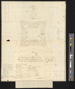
Fort William Henry
‹ Prev
Next ›
1
2
3
4
5
…
7
8