Toggle navigation
LMEC Home
Exhibitions
Georeferencing
Tools for Teachers
Collections
My Favorites
Sign Up / Log In
Search
Search the map portal
Map Collection
Map Collection
Map Sets
Search
Search
Search for
Search In
All Fields
Creator
Title
Subject
Place
Search All Digital Collections
Advanced Search
29 Results
My Search
Start Over
More Like
commonwealth:z603vt78z
Remove constraint More Like: commonwealth:z603vt78z
Creator
Jefferys, Thomas, -1771
Remove constraint Creator: Jefferys, Thomas, -1771
Filter your Search
Place
North and Central America
15
United States
9
Atlantic Ocean
3
Allegheny (county)
2
New York
2
North America
2
Pittsburgh
2
South America
2
more
Place
»
Topic
America--Discovery and Exploration--Maps--Early works to 1800
5
Tactics--Maps--Early works to 1800
4
Braddock's Campaign, 1755--Maps
3
United States--History--French and Indian War, 1754-1763--Maps
3
Braddock's Campaign, 1755--Maps--Early works to 1800
2
Maryland--Maps--Early works to 1800
2
Military camps--Maps--Early works to 1800
2
New York (N.Y.)--Maps--Early works to 1800
2
more
Topic
»
Date
Date range begin
–
Date range end
Current results range from
1753
to
1779
1753 : 1780
1753
1780
View distribution
Creator
Jefferys, Thomas, -1771
[remove]
29
Sayer, Robert, 1725-1794
16
Le Rouge, Georges-Louis
11
Green, John, -1757
6
Orme, Robert, -1781
5
Bowles, John, 1701-1779
2
Canot, Pierre Charles, 1710-1777
2
Howdell, Thomas
2
more
Creator
»
Format
Maps/Atlases
29
Georeferenced
No
29
Collection
American Revolutionary War-Era Maps
29
Richard H. Brown Revolutionary War Map Collection at Mount Vernon
29
Available to use
Creative Commons license
29
Search Constraints
Sort by relevance
relevance
title
date (asc)
date (desc)
Number of results to display per page
20 per page
10
per page
20
per page
50
per page
100
per page
View results as:
grid view
map view
Search Results
1.
Antigue : levée par Robert Baker, Arpenteur General de l'Isle ; traduit de l'Anglais
2.
La Barbade
3.
Bequia ou Becouya, le plus septentrionale des Granadilles : levé en 1763
4.
The Caribbee Islands and Guayana
5.
Chart comprizing Greenland with the countries and islands about Baffin's and Hudson's Bays
6.
Chart containing the coasts of California, New Albion, and Russian discoveries to the north : with the peninsula of Kamchatka,...
7.
Chart containing the greater part of the South Sea to the south of the line, with islands dispersed thro' the same
8.
A chart of North and South America, including the Atlantic and Pacific Oceans, with the nearest coasts of Europe, Africa and Asia
9.
Chart of South America, comprehending the West Indies, with the adjacent islands, in the Southern Ocean, and South Sea
10.
Chart of the Atlantic Ocean, with the British, French, & Spanish settlements in North America, and the West Indies : as also on...
11.
Curaçao : tiré des originaux Hollandois de Van Keulen ; dressé sur les dernieres observations
12.
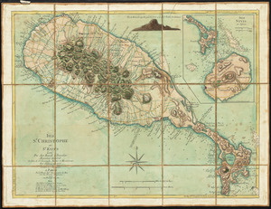
Isle St. Christophe ou St. Kitts
13.
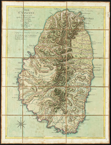
Isle St. Vincent
14.
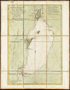
Les Isles Turques d'après les levées de 1753 par le sloop l'Aigle et l'Emeraude par ordre du Gouverneur de St. Domingue...
15.
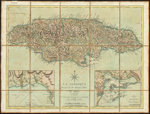
La Jamaique
16.
A map of the country between Will's Creek & Monongahela River shewing the rout and encampments of the English army in 1755
17.
A map of the most inhabited part of Virginia containing the whole province of Maryland with part of Pensilvania, New Jersey and...
18.
A new map of Nova Scotia, and Cape Britain : with the adjacent parts of New England and Canada, composed from a great number of...
19.
Plan of Fort le Quesne, built by the French at the fork of the Ohio and Monongahela in 1754
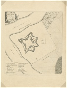
20.
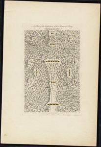
A plan of the disposition of the advanced party consisting of 400 men : to defend the workers in making the road
‹ Prev
Next ›
1
2