Toggle navigation
LMEC Home
Exhibitions
Georeferencing
Tools for Teachers
Collections
My Favorites
Sign Up / Log In
Search
Search the map portal
Map Collection
Map Collection
Map Sets
Search
Search
Search for
Search In
All Fields
Creator
Title
Subject
Place
Search All Digital Collections
Advanced Search
13694 Results
Filter your Search
Place
North and Central America
10,357
United States
8,484
Massachusetts
2,796
Suffolk (county)
1,678
Boston
1,634
Europe
1,419
Canada
950
New York
650
more
Place
»
Topic
Boston (Mass.)--Maps
748
City planning--Massachusetts--Boston--Maps
418
United States--History--Revolution, 1775-1783--Maps
329
United States--Maps
322
Real property--Massachusetts--Boston--Maps
254
Urban renewal--Massachusetts--Boston--Maps
254
Massachusetts--Maps
233
Insurance surveys
197
more
Topic
»
Date
Date range begin
–
Date range end
Current results range from
1482
to
2023
View distribution
Creator
United States. Hydrographic Office
597
Boston Redevelopment Authority
404
Des Barres, Joseph F. W. (Joseph Frederick Wallet), 1722-1824
247
Royal United Services Institute for Defence and Security Studies
160
Jefferys, Thomas, -1771
154
George, III, King of Great Britain, 1738-1820
152
George, IV, King of Great Britain, 1762-1830
151
O.H. Bailey & Co
148
more
Creator
»
Format
Maps/Atlases
13,513
Manuscripts
985
Prints
102
Books
49
Drawings/Illustrations
44
Photographs
15
Objects/Artifacts
13
Documents
7
more
Format
»
Georeferenced
Yes
979
No
12,715
Collection
Norman B. Leventhal Map & Education Center Collection
9,108
American Revolutionary War-Era Maps
3,305
Boston and New England Maps
2,921
Urban Maps
2,480
Maritime Charts and Atlases
1,169
William L. Clements Library Collection
910
Library of Congress Collection
618
Boston Redevelopment Authority Collection
475
more
Collection
»
Available to use
No known restrictions
10,260
Creative Commons license
1,678
Search Constraints
Sort by relevance
relevance
title
date (asc)
date (desc)
Number of results to display per page
20 per page
10
per page
20
per page
50
per page
100
per page
View results as:
grid view
map view
Search Results
13041.
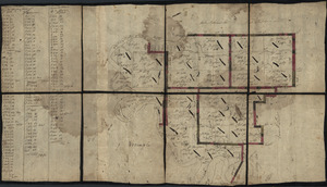
Utriusque Burgundiae, tum ducatus tum comitatus, descriptio
13042.
Uxbridge, Mass : 1880
13043.
Valatie, N.Y : 1881
13044.
Vallée de l'Amazone de Faro a Alemquer, Rio Trombetas - Rio Ariramba
13045.
Valley Forge, Pa. 1890
13046.
Valley of Blackstone River within the state of Mass
13047.
Valley of the Hudson River from Fishkill to Teller's Point
13048.
Van Loon's map of the United States : enlivened by thumbnail sketches of American history
13049.
A variation chart
13050.
Various plans and draughts of cities, towns, harbours &c
13051.
Various plans and draughts of cities, towns, harbours &c. drawn from the latest authorities
13052.
Vdrone Irlandiæ in Catherlagh Baronia
13053.
Veduta d'Italia
13054.
Velveray Corporation, S. Robert Stone, Incorporated (Ten.), Consolidated Thread Co. of Mass., Inc. (Bldg.), Cranska Thread...
13055.
Velveray Corporation, S. Robert Stone, Incorporated (Ten.), Consolidated Thread Co. of Mass., Inc. (Bldg.), Cranska Thread...
13056.
Venango Co
13057.
Venango railroad and its connections, air line from New York to Cleveland, Toledo & Chicago
13058.
Venezuela cum parte Australi Novae Andalusiae
13059.
Venezuela, cum partie Australi Novae Andalusiae
13060.
Venezuela with Trinidad and part of West Indies and British Guiana
‹ Prev
Next ›
1
2
…
649
650
651
652
653
654
655
656
657
…
684
685


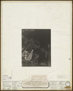
![Velveray Corporation, S. Robert Stone, Incorporated (Ten.), Consolidated Thread Co. of Mass., Inc. (Bldg.), Cranska Thread Company (Ten.), Fall River, Mass. [insurance map]](https://bpldcassets.blob.core.windows.net/derivatives/images/commonwealth:ww72bx38x/image_thumbnail_300.jpg)