Toggle navigation
LMEC Home
Exhibitions
Georeferencing
Tools for Teachers
Collections
My Favorites
Sign Up / Log In
Search
Search the map portal
Map Collection
Map Collection
Map Sets
Search
Search
Search for
Search In
All Fields
Creator
Title
Subject
Place
Search All Digital Collections
Advanced Search
13525 Results
Filter your Search
Place
North and Central America
10,237
United States
8,371
Massachusetts
2,781
Suffolk (county)
1,677
Boston
1,633
Europe
1,387
Canada
950
New York
641
more
Place
»
Topic
Boston (Mass.)--Maps
747
City planning--Massachusetts--Boston--Maps
418
United States--History--Revolution, 1775-1783--Maps
329
United States--Maps
321
Real property--Massachusetts--Boston--Maps
254
Urban renewal--Massachusetts--Boston--Maps
254
Massachusetts--Maps
230
Insurance surveys
197
more
Topic
»
Date
Date range begin
–
Date range end
Current results range from
1482
to
2023
View distribution
Creator
United States. Hydrographic Office
596
Boston Redevelopment Authority
404
Des Barres, Joseph F. W. (Joseph Frederick Wallet), 1722-1824
247
Royal United Services Institute for Defence and Security Studies
160
Jefferys, Thomas, -1771
154
George, III, King of Great Britain, 1738-1820
152
George, IV, King of Great Britain, 1762-1830
151
O.H. Bailey & Co
148
more
Creator
»
Format
Maps/Atlases
13,344
Manuscripts
985
Prints
102
Books
49
Drawings/Illustrations
44
Photographs
15
Objects/Artifacts
13
Documents
7
more
Format
»
Georeferenced
Yes
979
No
12,546
Collection
Norman B. Leventhal Map & Education Center Collection
9,029
American Revolutionary War-Era Maps
3,305
Boston and New England Maps
2,902
Urban Maps
2,426
Maritime Charts and Atlases
1,167
William L. Clements Library Collection
910
Library of Congress Collection
618
Boston Redevelopment Authority Collection
475
more
Collection
»
Available to use
No known restrictions
10,092
Creative Commons license
1,677
Search Constraints
Sort by relevance
relevance
title
date (asc)
date (desc)
Number of results to display per page
20 per page
10
per page
20
per page
50
per page
100
per page
View results as:
grid view
map view
Search Results
2781.
Dawson's map of the Dominion of Canada
2782.
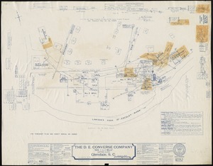
The D.E. Converse Company "Nos. 1 & 2 Mills" (Cotton Cloth), Glendale, S.C.
2783.
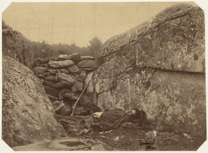
Dead rebel sharpshooter at Gettysburg
2784.
Deans, Krusensterns, and Lazareff Islands
2785.
Deans, Krusensterns, and Lazareff Islands
2786.
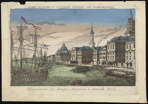
Débarquement des troupes Angloises à Nouvelle Yorck
2787.
Decatur, Ill : 1878
2788.
Decima Asiae tabula
2789.
Decima et ultima Europae tabula
2790.
Decima Europe tabula continent Macedonia et Epirum et Achaiam & Peloponesum
2791.
Dedication of the Army and Navy Monument, Sept. 17, 1877
2792.
Deering, Cumberland County, Maine : 1886
2793.
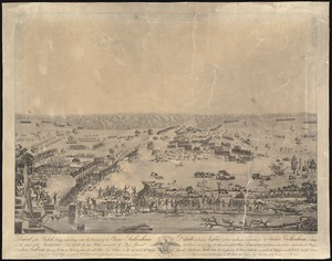
Defeat of the British army 12,000 strong under the command of Sir Edward Packenham in the attack of the American lines defended...
2794.
The Delancey lands on Manhattan Island
2795.
Delaware
2796.
Delaware and Maryland
2797.
Delaware Bay and Chesapeake Bay
2798.
Delaware Bay and Chesapeake Bay
2799.
Delaware, from the best authorities
2800.
Delaware, from the best authorities
‹ Prev
Next ›
1
2
…
136
137
138
139
140
141
142
143
144
…
676
677