Toggle navigation
LMEC Home
Exhibitions
Georeferencing
Tools for Teachers
Collections
My Favorites
Sign Up / Log In
Search
Search the map portal
Map Collection
Map Collection
Map Sets
Search
Search
Search for
Search In
All Fields
Creator
Title
Subject
Place
Search All Digital Collections
Advanced Search
13676 Results
Filter your Search
Place
North and Central America
10,342
United States
8,473
Massachusetts
2,788
Suffolk (county)
1,677
Boston
1,633
Europe
1,413
Canada
950
New York
649
more
Place
»
Topic
Boston (Mass.)--Maps
747
City planning--Massachusetts--Boston--Maps
418
United States--History--Revolution, 1775-1783--Maps
329
United States--Maps
322
Real property--Massachusetts--Boston--Maps
254
Urban renewal--Massachusetts--Boston--Maps
254
Massachusetts--Maps
231
Insurance surveys
197
more
Topic
»
Date
Date range begin
–
Date range end
Current results range from
1482
to
2023
View distribution
Creator
United States. Hydrographic Office
597
Boston Redevelopment Authority
404
Des Barres, Joseph F. W. (Joseph Frederick Wallet), 1722-1824
247
Royal United Services Institute for Defence and Security Studies
160
Jefferys, Thomas, -1771
154
George, III, King of Great Britain, 1738-1820
152
George, IV, King of Great Britain, 1762-1830
151
O.H. Bailey & Co
148
more
Creator
»
Format
Maps/Atlases
13,495
Manuscripts
985
Prints
102
Books
49
Drawings/Illustrations
44
Photographs
15
Objects/Artifacts
13
Documents
7
more
Format
»
Georeferenced
Yes
979
No
12,697
Collection
Norman B. Leventhal Map & Education Center Collection
9,093
American Revolutionary War-Era Maps
3,305
Boston and New England Maps
2,914
Urban Maps
2,469
Maritime Charts and Atlases
1,169
William L. Clements Library Collection
910
Library of Congress Collection
618
Boston Redevelopment Authority Collection
475
more
Collection
»
Available to use
No known restrictions
10,242
Creative Commons license
1,678
Search Constraints
Sort by relevance
relevance
title
date (asc)
date (desc)
Number of results to display per page
20 per page
10
per page
20
per page
50
per page
100
per page
View results as:
grid view
map view
Search Results
301.
Algemeene kaart van Nederlandsch Oostindie : met hoogstdeszelfs toestemming opgedragen aan zijne Majesteit den Koning der...
302.
Algeria and Tunisia, port capacities and major transport routes
303.
Alien and Sedition Acts, February 25, 1799, Votes on resolutions for repeal
304.
Alla serma. sigra. principsa. d'Vrbino Grandvchessa di Toscana sva sigra. d: Roberto Dvdleo Dvca di Northumbria
305.
[Alleen de Caribische Eilanden, vervat in 't groot]
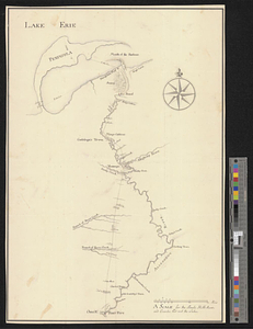
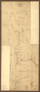
306.
Allegheny River and French Creek
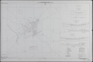
307.
Allentown-Bethlehem-Easton Airport, Allentown, Pennsylvania
308.
Allgemeine charte von Nord America als den sitz des krieges zwischen den Konigl. Engl. truppen u:den provinzialen
309.
Allston Park, Boston, Mass
310.
Allston-Brighton open space plan site inventory
311.
Alma, Michigan : 1885
312.
An alphabetical table of all the cities, towns, villages and all other places of merit in the Kingdom of France, & circumjacent...
313.
The Alpine Club map of Switzerland with parts of the neighbouring countries
314.
Alsace
315.
Alton and Alton Bay, N.H : 1888
316.
Ambivareti in Aeduis, ubi postea Vadicasses : Evesché de Nevers
317.
Amboy to Elizabethtown
318.
Ambuscade of the Indians at Kingsbridge : August 31st. 1778
319.
Amended zoning map for town of Wakefield Mass.
320.
America
‹ Prev
Next ›
1
2
…
12
13
14
15
16
17
18
19
20
…
683
684


![[Alleen de Caribische Eilanden, vervat in 't groot]](https://bpldcassets.blob.core.windows.net/derivatives/images/commonwealth:st74cw59p/image_thumbnail_300.jpg)