Toggle navigation
LMEC Home
Exhibitions
Georeferencing
Tools for Teachers
Collections
My Favorites
Sign Up / Log In
Search
Search the map portal
Map Collection
Map Collection
Map Sets
Search
Search
Search for
Search In
All Fields
Creator
Title
Subject
Place
Search All Digital Collections
Advanced Search
2843 Results
My Search
Start Over
atlas
Remove constraint atlas
Filter your Search
Place
North and Central America
1,647
United States
987
Europe
464
Massachusetts
348
Canada
271
Asia
190
South America
189
Suffolk (county)
163
more
Place
»
Topic
Landowners--Massachusetts--Boston--Maps
115
Real property--Massachusetts--Boston--Maps
106
United States--Maps
87
Boston (Mass.)--Maps
63
United States--History--French and Indian War, 1754-1763--Maps
63
Saint Lawrence River--Maps
41
Nautical charts--Early works to 1800
39
North America--Maps--Early works to 1800
36
more
Topic
»
Date
Date range begin
–
Date range end
Current results range from
1482
to
2023
View distribution
Creator
United States. Hydrographic Office
582
Des Barres, Joseph F. W. (Joseph Frederick Wallet), 1722-1824
118
Ptolemy, 2nd cent
100
Bromley, George Washington
99
Bromley, Walter Scott
97
G.W. Bromley & Co.
75
Carey, Mathew, 1760-1839
74
Paullin, Charles Oscar, 1868 or 1869-1944
70
more
Creator
»
Format
Maps/Atlases
2,827
Manuscripts
58
Books
37
Prints
8
Documents
5
Drawings/Illustrations
1
Georeferenced
Yes
142
No
2,701
Collection
Norman B. Leventhal Map & Education Center Collection
2,386
Maritime Charts and Atlases
1,150
American Revolutionary War-Era Maps
504
Boston and New England Maps
374
Urban Maps
250
Massachusetts Real Estate Atlases
144
William L. Clements Library Collection
92
Mapping Boston Collection
61
more
Collection
»
Available to use
No known restrictions
2,292
Creative Commons license
158
Search Constraints
Sort by relevance
relevance
title
date (asc)
date (desc)
Number of results to display per page
20 per page
10
per page
20
per page
50
per page
100
per page
View results as:
grid view
map view
Search Results
2821.
Insurance maps of Malden, Middlesex Co., Massachusetts
2822.
Insurance maps of Ware, Hampshire County, Massachusetts
2823.
Warren, Worcester County, Massachusetts, November 1911 : including West Warren
2824.
Plan of that part of Canada and the River St. Lawrence which lies between Point du Lac and Repentigny on the north shore &...
2825.
Charlestown Veterans Memorial, Charlestown, Massachusetts
2826.
Copies of plans of various parts of Brookline and Roxbury
2827.
Insurance maps of Boston volume 4 : comprising portions of Charlestown, East Cambridge, Cambridge Port, Old Cambridge & Somerville
2828.
John Hancock office and parking garage complex, Boston, Massachusetts
2829.
Plan for the construction of improvements at the Boston Common
2830.
Plan of the city of Boston
2831.
Rose Kennedy Garden : contract documents August 1986 : prepared for City of Boston ; Parks & Recreations Department ; Boston...
2832.
Site preparation contract for the reconstruction of Copley Square Park, City of Boston, Massachusetts : contract documents
2833.
Insurance maps of the city of New York
2834.
Town of Brookline, Mass. assessors' plans 1930
2835.
Town of Brookline Mass. Assessors' plans 1943
2836.
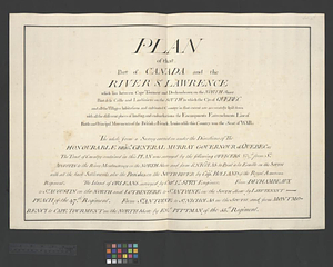
Plan of that part of Canada and the River St. Lawrence which lies between Cape Tourment and Dechambeaux on the north shore...
2837.
Insurance map of Chicago, 1868-9
2838.
Town of Belmont Assessors plans
2839.
Town of Belmont Massachusetts
2840.
Waltham, 1911
‹ Prev
Next ›
1
2
…
138
139
140
141
142
143