Toggle navigation
LMEC Home
Exhibitions
Georeferencing
Tools for Teachers
Collections
My Favorites
Sign Up / Log In
Search
Search the map portal
Map Collection
Map Collection
Map Sets
Search
Search
Search for
Search In
All Fields
Creator
Title
Subject
Place
Search All Digital Collections
Advanced Search
13385 Results
Filter your Search
Place
North and Central America
9,353
United States
7,286
Suffolk (county)
1,664
Boston
1,621
Europe
1,035
Canada
949
Massachusetts
806
New York
534
more
Place
»
Topic
Boston (Mass.)--Maps
741
City planning--Massachusetts--Boston--Maps
418
United States--History--Revolution, 1775-1783--Maps
329
United States--Maps
315
Urban renewal--Massachusetts--Boston--Maps
254
Real property--Massachusetts--Boston--Maps
252
Massachusetts--Maps
219
Insurance surveys
197
more
Topic
»
Date
Date range begin
–
Date range end
Current results range from
1482
to
2023
View distribution
Creator
United States. Hydrographic Office
595
Boston Redevelopment Authority
403
Des Barres, Joseph F. W. (Joseph Frederick Wallet), 1722-1824
247
Royal United Services Institute for Defence and Security Studies
160
Jefferys, Thomas, -1771
154
George, III, King of Great Britain, 1738-1820
152
George, IV, King of Great Britain, 1762-1830
151
O.H. Bailey & Co
148
more
Creator
»
Format
Maps/Atlases
13,205
Manuscripts
985
Prints
102
Books
49
Drawings/Illustrations
44
Photographs
15
Objects/Artifacts
13
Documents
7
more
Format
»
Georeferenced
Yes
979
No
12,406
Collection
Norman B. Leventhal Map Center Collection
8,891
American Revolutionary War-Era Maps
3,305
Boston and New England Maps
2,804
Urban Maps
2,397
Maritime Charts and Atlases
1,150
William L. Clements Library Collection
910
Library of Congress Collection
618
Boston Redevelopment Authority Collection
475
more
Collection
»
Available to use
No known restrictions
9,952
Creative Commons license
1,677
Search Constraints
Sort by relevance
relevance
title
date (asc)
date (desc)
Number of results to display per page
100 per page
10
per page
20
per page
50
per page
100
per page
View results as:
grid view
map view
Search Results
12801.
VIEW of a Cottage on the Island MASSACRE near the MOBILLE W. FLORIDA. Oct.r 1764
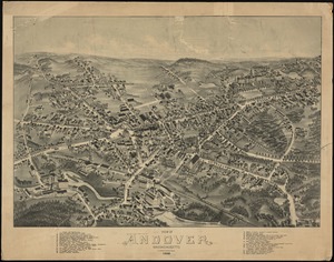
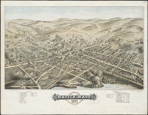
12802.
View of Amherst, Mass
12803.
View of Andover, Massachusetts : 1882
12804.
View of Andover, Massachusetts : 1882
12805.
View of Ansonia, Conn : 1875
12806.
View of Ashland, Mass : 1878
12807.
View of Athol, Mass : 1878
12808.
View of Attleborough, Mass : East Village, 1878
12809.
View of Bethel, Conn
12810.
View of Beverly, Mass
12811.
A view of Boston
12812.
View of Boston freight terminals, the New York, New Haven & Hartford Railroad
12813.
A view of Boston from Dorchester neck : Long Island open on the north side of Nicks Mate Island ; Boston from Willis Creek
12814.
View of Boston, July 4th 1870
12815.
View of Boston, July 4th 1870
12816.
A view of Boston taken on the road to Dorchester
12817.
VIEW of BOSTON the Capital of NEW ENGLAND from Col. HATCH's House on the Road to DORCHESTER = VIEW FROM DORCHESTER NECK = VIEW...
12818.
View of Bristol, Conn
12819.
View of Canton, Mass : 1878
12820.
View of Cape Egmont and winter Rock from the eastward : Entrance of Egmont Harbor ; The entrance of Keppel Harbor, 10 leagues...
12821.
View of Cape Egmont and Winter Rock from the eastward ; Entrance of Egmont Harbor ; The entrance of Keppel Harbor ... ; Falls...
12822.
View of Cape Egmont and Winter Rock from the eastward ; Entrance of Egmont Harbor ; The entrance of Keppel Harbor ... ; Falls...
12823.
View of Chatham : New Brunswick
12824.
View of Cheshire, Connecticut : 1882
12825.
View of Chester, Connecticut : 1881
12826.
View of Clinton, Connecticut : 1881
12827.
View of College Point, L.I : 1876
12828.
View of Collinsville, Conn : 1878
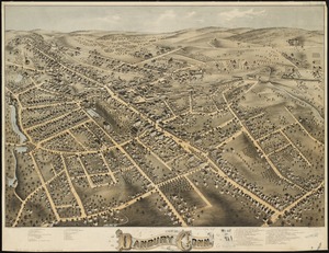
12829.
View of Danbury, Conn : 1875
12830.
View of Dedham, Mass. in 1876
12831.
View of Dorchester Neck from Enoch Brown's
12832.
View of Dorchester Neck, from the mess house on Fort Hill
12833.
View of Dorchester Neck, from the mess house on Fort Hill
12834.
View of East Boston, Mass : 1879
12835.
View of East Cambridge, Mass., 1879
12836.
View of Essex, Centerbrook & Ivoryton, Conn : 1881
12837.
View of Forestville, Conn : 1880
12838.
A view of Fort Harmer at 100 yards distance from projecting angle of a bastion
12839.
View of Franklin, Mass : 1879
12840.
View of Grafton, Massachusetts : 1887
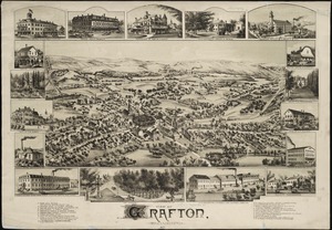
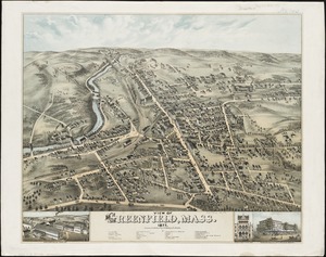
12841.
View of Greenfield, Mass
12842.
View of Guilford, Connecticut : 1881
12843.
VIEW of HARLAEM from MORISANIA in the PROVINCE of NEW YORK Septem.r 1765
12844.
View of Hazardville, Connecticut
12845.
View of Higganum, Connecticut : 1881
12846.
View of Holliston, Mass : 1878
12847.
View of Hopedale, Massachusetts : 1888
12848.
View of Hyde Park, Mass., 1879
12849.
View of Lambertville, New Jersey
12850.
View of Lowell, Mass : taken from the house of Elisha Fuller Esq. in Dracut
12851.
View of Lynn, Mass. in 1849 : from High Rock
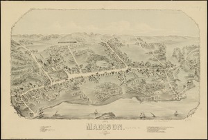
12852.
View of Madison, Conn : 1881
12853.
View of Mansfield, Mass : 1879
12854.
View of Marlborough, Mass : 1879
12855.
View of Medway, Massachusetts : 1887
12856.
View of Methuen, Massachusetts : 1882
12857.
View of Middletown, N.Y : 1874
12858.
View of Milford, Conn : 1882
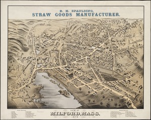
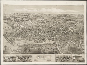
12859.
View of Milford, Mass : 1876
12860.
A view of Miramichi, a French settlement in the Gulf of St. Laurence, destroyed by Brigadier Murray detached by General Wolfe...
12861.
View of Mystic River & Mystic Bridge, Conn. 1879
12862.
View of Natick, Mass : 1877, population about 8000
12863.
View of Naugatuck, Conn : 1877
12864.
View of New Britain, Conn : 1875
12865.
View of New Canaan, Conn : 1878
12866.
A view of New Castle with the fort and light house on the entrance of Piscataqua River
12867.
View of New Milford, Conn : 1882
12868.
View of Newton, Mass : comprising Wards 1 & 7 & environs of the city of Newton
12869.
View of North Easton, Massachusetts, 1881
12870.
View of North Manchester, Connecticut : 1880
12871.
View of Northborough, Massachusetts : 1887
12872.
View of Oneida, N.Y : 1874
12873.
View of Palmer, Mass
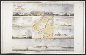
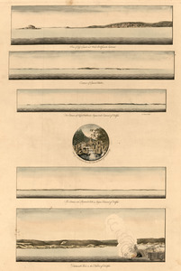
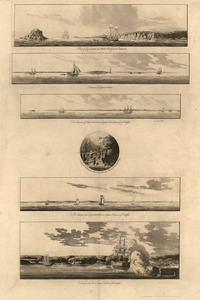
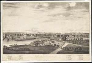
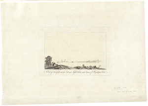
12874.
A view of part of the town of Boston in New-England and Brittish [sic] ships of war landing their troops! 1768
12875.
A view of Partridge Island, from the west
12876.
A view of Partridge Island, from the west
12877.
View of Peabody, Mass : 1877
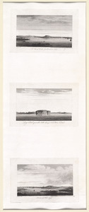
12878.
A view of Port Hood, sailing into the harbor : A view of the Plaister Cliffs, in George's Bay
12879.
A view of Portsmouth in Piscataqua River
12880.
[View of Portsmouth, N.H.]
12881.
View of Public Square, Atlanta, Ga.
12882.
View of Putnam, Conn : 1877
12883.
View of Randolph, Mass : 1882
12884.
View of Rockville, Conn : 1877
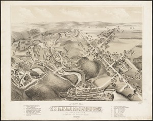
12885.
View of Saxonville, Mass
12886.
View of Sea Isle City : New Jersey
12887.
View of Seymour, Conn : 1879
12888.
View of Somerset, Massachusetts
12889.
View of South Braintree, Massachusetts : 1882
12890.
View of South Coventry, Conn : 1878
12891.
View of Southbridge, Mass : Center & Globe Village, 1878
12892.
View of SoWa food trucks
12893.
View of Springfield, Mass : 1875
12894.
View of Stafford Springs, Conn : 1878
12895.
View of Stamford, Conn : 1875
12896.
View of Stoneham, Mass : 1878
12897.
View of Stonington, Conn : 1879
12898.
A view of the castle of Belem and the city of Lisbon as it appears from thence ; A map of the mouth of the famous river Tagus...
12899.
[View of the Charles River]
12900.
View of the city of New Bedford, Mass : 1876
‹ Prev
Next ›
1
2
…
125
126
127
128
129
130
131
132
133
134