Toggle navigation
LMEC Home
Exhibitions
Georeferencing
Tools for Teachers
Collections
My Favorites
Sign Up / Log In
Search
Search the map portal
Map Collection
Map Collection
Map Sets
Search
Search
Search for
Search In
All Fields
Creator
Title
Subject
Place
Search All Digital Collections
Advanced Search
5289 Results
My Search
Start Over
Date Range
before 1800
Remove constraint Date Range: before 1800
Filter your Search
Place
North and Central America
3,721
United States
2,498
Canada
655
Europe
652
Massachusetts
471
New York
376
North America
307
Maine
205
more
Place
»
Topic
United States--History--Revolution, 1775-1783--Maps
323
North America--Maps--Early works to 1800
179
United States--History--French and Indian War, 1754-1763--Maps
161
Manuscript maps--Early works to 1800
137
New England--Maps--Early works to 1800
89
World maps--Early works to 1800
76
America--Maps--Early works to 1800
73
Saint Lawrence River--Maps
63
more
Topic
»
Date
Date range begin
–
Date range end
Current results range from
1482
to
1990
View distribution
Creator
Des Barres, Joseph F. W. (Joseph Frederick Wallet), 1722-1824
245
Royal United Services Institute for Defence and Security Studies
158
Jefferys, Thomas, -1771
153
George, III, King of Great Britain, 1738-1820
152
George, IV, King of Great Britain, 1762-1830
151
Amherst, Jeffery Amherst, Baron, 1717-1797
130
Sayer, Robert, 1725-1794
107
Faden, William, 1749-1836
106
more
Creator
»
Format
Maps/Atlases
5,176
Manuscripts
787
Prints
59
Drawings/Illustrations
36
Books
11
Documents
5
Objects/Artifacts
3
Ephemera
1
Georeferenced
Yes
156
No
5,133
Collection
American Revolutionary War-Era Maps
3,277
Norman B. Leventhal Map & Education Center Collection
2,099
William L. Clements Library Collection
905
Library of Congress Collection
618
Town plans, 1794
403
British Library Collection
375
Maritime Charts and Atlases
371
Richard H. Brown Revolutionary War Map Collection at Mount Vernon
294
more
Collection
»
Available to use
No known restrictions
2,477
Creative Commons license
1,559
Search Constraints
Sort by relevance
relevance
title
date (asc)
date (desc)
Number of results to display per page
20 per page
10
per page
20
per page
50
per page
100
per page
View results as:
grid view
map view
Search Results
5281.
Xingye dingxiang fang yangzhitu
5282.
Yeojido
5283.
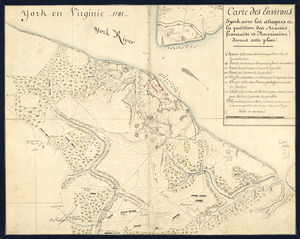
York en Virginie, 1781 : Carte des environs d'York avec les attaques à la position des Armées francaise et americaine devant...
5284.
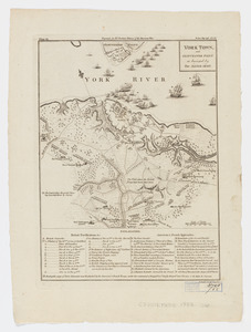
York Town, and Gloucester Point : as besieged by the Allied Army
5285.
Yorktown, Virginia, and the surrounding area, ca. 1781
5286.
Ypra
5287.
Ysla de Cuba
5288.
Zeilan Insula
5289.
Die zerstörung der königlichen bild säule zu Neu Yorck = : La destruction de la statue royale a Nouvelle Yorck
‹ Prev
Next ›
1
2
…
261
262
263
264
265