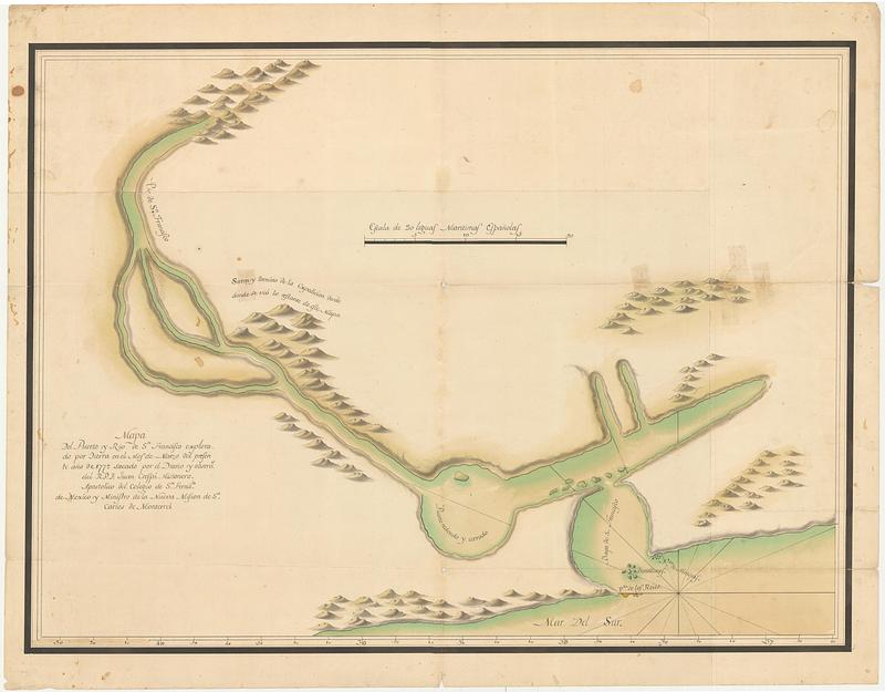
Mapa del puerto y rio de S.n Francisco explorado por tierra en el mes de Marzo del presen te ano de 1772
This map is also available in American Revolutionary Geographies Online (ARGO), a collections portal especially built for material relating to the American Revolutionary War Era. Visit ARGO to learn more about this item and explore the historical geography of North America in the late eighteenth century.
Item Information
- Title:
- Mapa del puerto y rio de S.n Francisco explorado por tierra en el mes de Marzo del presen te ano de 1772
- Publisher:
- Crespí, Juan, 1721-1782
- Name on Item:
-
sacado por el diario y observa[cione]s del R.P.F. Juan Crespi Misionero, Apostolico del Colegio de S[a]n Ferna[n].do de Mexico y ministro de la nueva mision de S[a]n Carlos de Monterrei
- Date:
-
1772
- Format:
-
Maps/Atlases
- Genre:
-
Manuscript maps
- Location:
- MacLean Collection Map Library
- Collection (local):
-
MacLean Collection Map Library
- Subjects:
-
San Francisco Bay Area (Calif.)--Maps--Early works to 1800
Sacramento River (Calif.)--Maps--Early works to 1800
- Places:
-
CaliforniaSan Francisco Bay
CaliforniaSacramento (river)
- Extent:
- 1 ms map ; 450 x 610 mm
- Terms of Use:
-
Public Domain/No known restrictions on use. Contact host institution to download image.
Contact host institution for more information.
- Publisher:
-
Monterey + Mexico City :
Crespi, Juan
- Language:
-
Spanish
- Identifier:
-
MC_534
- Call #:
-
534