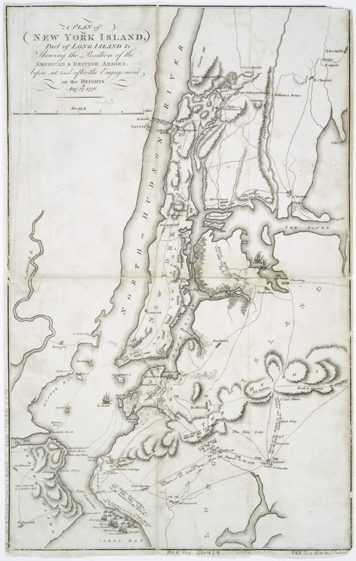
A plan of New York Island, part of Long Island &c : shewing the position of the American & British armies, before, at, and after the engagement on the Heights, Aug. 27th, 1776
This map is also available in American Revolutionary Geographies Online (ARGO), a collections portal especially built for material relating to the American Revolutionary War Era. Visit ARGO to learn more about this item and explore the historical geography of North America in the late eighteenth century.
Item Information
- Title:
- A plan of New York Island, part of Long Island &c : shewing the position of the American & British armies, before, at, and after the engagement on the Heights, Aug. 27th, 1776
- Creator:
- Neele, Samuel John, 1758-1824
- Name on Item:
-
Neele, s[culpt?]
- Date:
-
[1806?]
- Format:
-
Maps/Atlases
- Location:
- New York Public Library
- Collection (local):
-
Maps of New York City and State
- Subjects:
-
Long Island, Battle of, New York, N.Y., 1776--Maps
New York (N.Y.)--History--Revolution, 1775-1783--Maps
New York Metropolitan Area--Maps
- Places:
-
New York
- Extent:
- 1 map ; 41 x 26 cm.
- Terms of Use:
-
No known copyright restrictions.
This work is licensed for use under a Creative Commons Attribution Non-Commercial Share Alike License (CC BY-NC-SA).

- Publisher:
-
London? :
[s.n.]
- Scale:
-
Scale [ca. 1:100,000]
- Catalog Record:
-
https://digitalcollections.nypl.org/items/510d47da-ee3c-a3d9-e040-e00a18064a99
- Notes:
-
Imprint information from NYPL's Dictionary catalog of the Map Division.
Relief shown by hachures.