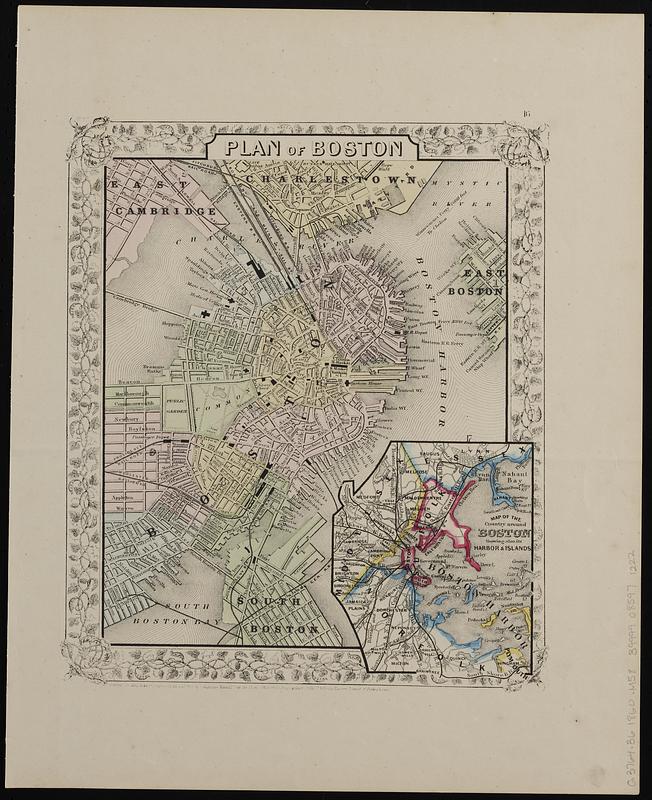
Plan of Boston
Item Information
- Title:
- Plan of Boston
- Publisher:
- Mitchell, S. Augustus, Jr. (Samuel Augustus)
- Date:
-
1860
- Format:
-
Maps/Atlases
- Location:
-
Boston Public Library
Norman B. Leventhal Map & Education Center - Collection (local):
-
Norman B. Leventhal Map & Education Center Collection
- Subjects:
-
Boston (Mass.)--Maps
Boston Harbor (Mass.)--Maps
East Cambridge (Mass.)--Maps
Charlestown (Boston, Mass.)--Maps
Counties--Massachusetts--Maps
Cities and towns--Massachusetts--Maps
Railroads--Massachusetts--Boston--Maps
Streets--Massachusetts--Boston--Maps
Buildings--Massachusetts--Boston--Maps
Ferries--Massachusetts--Boston--Maps
Parks--Massachusetts--Boston--Maps
Roads--Massachusetts--Maps
- Places:
-
MassachusettsSuffolk (county)Boston
MassachusettsBoston Harbor
MassachusettsMiddlesex (county)CambridgeEast Cambridge
- Extent:
- 1 map : color ; 24 x 21 cm
- Terms of Use:
-
No known copyright restrictions.
No known restrictions on use.
- Publisher:
-
[Philadelphia] :
S. Augustus Mitchell, Jr.
- Scale:
-
Scale approximately 1:17,500
- Language:
-
English
- Notes:
-
Shows railroads, street names, buildings, ferry routes and distances, and parks for Boston, and parts of East and South Boston, Charlestown, and East Cambridge; shows cities, railroads and major roads for Essex, Suffolk, Norfolk, and Middlesex counties, on inset.
Oriented with north to the upper right.
"Entered according to Act of Congress in the year 1860 by S. Augustus Mitchell, Jr. in the Clerks Office of the District Court of the U.S. for the Eastern District of Pennsylvania."
Inset: Map of the country around Boston showing also, its harbor & islands.
In right upper margin: 16.
Includes ornamental border.
- Identifier:
-
06_01_019148
- Call #:
-
G3764.B6 1860 .M58
- Barcode:
-
39999085971222


