British Isles
Item Information
- Title:
- British Isles
- Description:
-
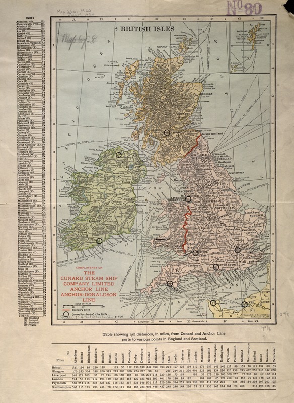
Published for the Cunard Steam Ship Company in the 1920s, this map locates the company's ports in the British Isles. It also displays the various routes connecting these ports with each other and other ports in Europe and America. Established in 1840 primarily as a mail line, by 1920 the Cunard Steam Ship Company was the premier trans-Atlantic cruise line, boasting among its fleet such famed vessels as the "Brittania", the "Mauritania", and the "Lusitania" (the latter of which was lost to a German U-boat in 1915). The Cunard line would later grow to include the "Queen Elizabeth II", which still serves the trans-Atlantic route.
- Creator:
- Cunard Steamship Company, ltd
- Name on Item:
-
Cunard Steamship Co.
- Date:
-
1920
- Format:
-
Maps/Atlases
- Location:
-
Boston Public Library
Norman B. Leventhal Map & Education Center - Collection (local):
-
Norman B. Leventhal Map & Education Center Collection
- Subjects:
-
British Isles--Maps
- Places:
-
British Isles (area)
- Extent:
- 1 map : col. ; 31.75 x 22.86 cm.
- Terms of Use:
-
No known copyright restrictions.
No known restrictions on use.
- Publisher:
-
New York :
C.S. Hammond & Co.
- Scale:
-
Scale [ca. 1:4,524,000]
- Language:
-
English
- Notes:
-
Relief shown by hachures.
Includes index and table showing rail distances.
Exhibited in “Faces and Places,” at the Boston Public Library, Boston, MA, October 2003 - September 2004. MB (BRL)
- Identifier:
-
05_04_000030
- Call #:
-
G5740 1920 .C8
- Barcode:
-
39999052509906