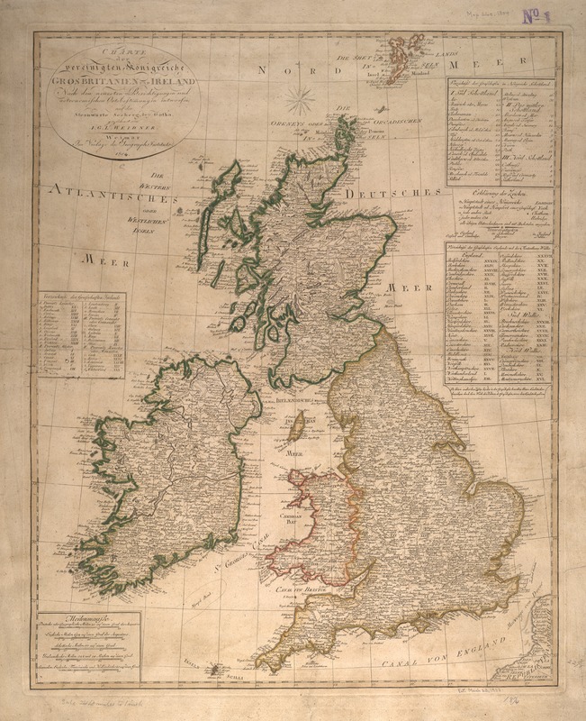
Charte der vereinigten Königreiche Grosbritanien und Ireland : nach den neuesten Berichtigungen und Astronomischen Ortsbesti[m]mungen entworfen auf den Sternwarte Seeberg, bey Gotha
Item Information
- Title:
- Charte der vereinigten Königreiche Grosbritanien und Ireland : nach den neuesten Berichtigungen und Astronomischen Ortsbesti[m]mungen entworfen auf den Sternwarte Seeberg, bey Gotha
- Description:
-
Published by the Geographische Institut in Weimar, Germany, this map of Great Britain and Ireland shows extraordinary detail for such an early date. The coastal features, rivers, and towns were placed with a high degree of accuracy, attributed in part, as the caption says, to the "latest reports and astronomical observations." The insets identify the location of counties and provinces within England, Ireland, and Scotland. Longitude is measured east from Ferro.
- Creator:
- Weidner, I. G. A.
- Name on Item:
-
gezeichnet von I.G.L. Weidner.
- Date:
-
1804
- Format:
-
Maps/Atlases
- Location:
-
Boston Public Library
Norman B. Leventhal Map & Education Center - Collection (local):
-
Norman B. Leventhal Map & Education Center Collection
- Subjects:
-
British Isles--Maps
British Isles--Administrative and political divisions--Maps
- Places:
-
British Isles (area)
- Extent:
- 1 map : col. ; 55 x 67 cm.
- Terms of Use:
-
No known copyright restrictions.
No known restrictions on use.
- Publisher:
-
Weimar :
Geographisches Institut
- Scale:
-
Scale [ca. 1:2,100,000]
- Language:
-
German
- Notes:
-
Shows the countries of England, Wales, Scotland and Ireland.
Relief shown by hachures.
Includes indexes to counties in England, Wales, Scotland and Ireland.
Exhibited in “Faces and Places,” at the Boston Public Library, Boston, MA, October 2003 - September 2004. MB (BRL)
- Identifier:
-
05_04_000029
- Call #:
-
G5740 1804 .W4
- Barcode:
-
39999052509849